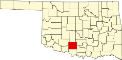
Meridian, Stephens County, Oklahoma

Last updated

Meridian is a former census-designated place (CDP) in Stephens County, Oklahoma, United States. The population was 1,485 at the 2000 census. As of the 2020 census, the area, plus land to the north, was part of the Sunray CDP. [1]

Contents

Geography

Meridian is located at 34°25′01″N97°58′11″W / 34.416951°N 97.969636°W / 34.416951; -97.969636 Coordinates: 34°25′01″N97°58′11″W / 34.416951°N 97.969636°W / 34.416951; -97.969636 (34.416951, -97.969636). [2] According to the United States Census Bureau, the CDP has a total area of 7.6 square miles (19.8 km2), of which 7.6 square miles (19.8 km2) is land and 0.13% is water.

Demographics

As of the census [3] of 2000, there were 1,485 people, 552 households, and 439 families residing in the CDP. The population density was 194.6 people per square mile (75.1/km2). There were 643 housing units at an average density of 84.3/sq mi (32.5/km2). The racial makeup of the CDP was 85.93% White, 0.20% African American, 9.02% Native American, 0.07% Asian, 0.40% from other races, and 4.38% from two or more races. Hispanic or Latino of any race were 1.75% of the population.

There were 552 households, out of which 32.4% had children under the age of 18 living with them, 67.8% were married couples living together, 8.3% had a female householder with no husband present, and 20.3% were non-families. 17.2% of all households were made up of individuals, and 7.8% had someone living alone who was 65 years of age or older. The average household size was 2.69 and the average family size was 3.02.

In the CDP, the population was spread out, with 26.8% under the age of 18, 7.5% from 18 to 24, 25.8% from 25 to 44, 24.6% from 45 to 64, and 15.2% who were 65 years of age or older. The median age was 39 years. For every 100 females, there were 100.7 males. For every 100 females age 18 and over, there were 95.9 males.

The median income for a household in the CDP was $34,196, and the median income for a family was $37,545. Males had a median income of $28,816 versus $18,958 for females. The per capita income for the CDP was $15,822. About 8.2% of families and 12.0% of the population were below the poverty line, including 17.1% of those under age 18 and 8.1% of those age 65 or over.

Related Research Articles

Gateway, Alaska CDP in Alaska, United States

Gateway is a census-designated place (CDP) in Matanuska-Susitna Borough, Alaska, United States. It is part of the Anchorage, Alaska Metropolitan Statistical Area. The population was 5,552 at the 2010 census, up from 2,952 in 2000.

Summit, Arizona CDP in Pima County, Arizona

Summit is a census-designated place (CDP) in Pima County, Arizona, United States. The population was 3,702 at the 2000 census.

Waldon, California former Census-designated place in California, United States

Waldon is a former census-designated place (CDP) in Contra Costa County, California, United States. The population was 5,133 at the 2000 census. It is served by Pleasant Hill/​Contra Costa Centre station on the Bay Area Rapid Transit (BART) Antioch–​SFO + Millbrae Line, and by Interstate 680. The area has been undergoing a series of transit-oriented development projects under the auspices of the Contra Costa Centre Transit Village public/private partnership.

Laurel, Florida Census-designated place in Florida, United States

Laurel is a census-designated place (CDP) in Sarasota County, Florida, United States. The population was 8,171 at the 2010 census. People who live in the CDP have a Nokomis mailing address and signs along U.S. 41 refer to the entire extent between Roberts Bay and South Creek as "Nokomis."

St. Augustine Shores, Florida CDP in Florida, United States

St. Augustine Shores is a census-designated place (CDP) in St. Johns County, Florida, United States. As of the 2000 census, the CDP population was 4,922.

Fort Pierce North, Florida CDP in Florida, United States

Fort Pierce North is a census-designated place (CDP) in St. Lucie County, Florida, United States. The population was 6,474 at the 2010 census. It is part of the Port St. Lucie Metropolitan Statistical Area.

Meridian Station, Mississippi Census-designated place in Mississippi, United States

Meridian Station is a census-designated place (CDP) in Lauderdale County, Mississippi, United States, corresponding to the residential portions of Naval Air Station Meridian. The population was 1,090 at the 2010 census.

Brass Castle, New Jersey Census-designated place in New Jersey, United States

Brass Castle is an unincorporated community and census-designated place (CDP) located within Washington Township, in Warren County, New Jersey, United States. As of the 2010 United States Census, the CDP's population was 1,555. It is located in the easternmost region of the Lehigh Valley.

Dry Run, Ohio Census-designated place in Ohio, United States

Dry Run is a census-designated place (CDP) in Hamilton County, Ohio, United States. The population was 7,281 at the 2010 census.

West Hills, Pennsylvania Census-designated place in Pennsylvania, United States

West Hills is a census-designated place (CDP) in Armstrong County, Pennsylvania, United States. The population was 1,263 at the 2010 census.

Meridian, Pennsylvania Census-designated place in Pennsylvania, United States

Meridian is a census-designated place (CDP) in Butler County, Pennsylvania, United States. The population was 3,881 at the 2010 census.

Indian Hills, Texas Census-designated place in Texas

Indian Hills is a census-designated place (CDP) in Hidalgo County, Texas, United States. At the 2010 United States Census, the population was 2,591. It is part of the McAllen–Edinburg–Mission Metropolitan Statistical Area.

North San Pedro, Texas CDP in Texas, United States

North San Pedro is a census-designated place (CDP) in Nueces County, Texas, United States. The population was 895 at the 2010 census, down from 920 at the 2000 census.

Rendon, Texas CDP in Texas, United States

Rendon is a census-designated place (CDP) in Tarrant County, Texas, United States. The population was 12,552 at the 2010 census.

Palmyra, Utah CDP in Utah, United States

Palmyra is a census-designated place (CDP) in Utah County, Utah, United States. It is part of the Provo–Orem Metropolitan Statistical Area. The population was 491 at the 2010 census. Palmyra is located directly west of Springville and northwest of Spanish Fork.

Timber Lakes, Utah CDP in Utah, United States

Timber Lakes is a census-designated place (CDP) in Wasatch County, Utah, United States. The population was 607 at the 2010 census, up from 289 in 2000.

Lewisville, Washington Census-designated place in Washington, United States

Lewisville is a census-designated place (CDP) in Clark County, Washington, United States. The population was 1,722 at the 2010 census.

East Hill-Meridian, Washington Former CDP in Washington, United States

East Hill-Meridian is a former census-designated place (CDP) in King County, Washington. The population was 29,878 at the time of the 2010 census. The majority of the census area is now within the limits of Kent and Renton.

Coal City, West Virginia Census-designated place in West Virginia, United States

Coal City is a census-designated place (CDP) in Raleigh County, West Virginia, United States. The population was 1,815 at the 2010 census. Coal City's population is composed of other surrounding unincorporated communities.

Bar Harbor (CDP), Maine Census-designated place in Maine, United States

Bar Harbor is a census-designated place (CDP) in the town of Bar Harbor in Hancock County, Maine, United States. The CDP population was 2,552 at the 2010 census, out of a population of 5,235 in the town of Bar Harbor as a whole.

References

  1. U.S. Geological Survey Geographic Names Information System: Sunray Census Designated Place
  2. "US Gazetteer files: 2010, 2000, and 1990". United States Census Bureau. 2011-02-12. Retrieved 2011-04-23.
  3. "U.S. Census website". United States Census Bureau . Retrieved 2008-01-31.