Loco, Oklahoma

Last updated

Loco, Oklahoma
OKMap-doton-Loco.PNG
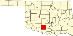
Location of Loco, Oklahoma
Coordinates: 34°19′46″N97°40′50″W / 34.32944°N 97.68056°W / 34.32944; -97.68056
Country United States
State Oklahoma
County Stephens
Area
[1]
  Total0.26 sq mi (0.68 km2)
  Land0.26 sq mi (0.68 km2)
  Water0.00 sq mi (0.00 km2)
Elevation
[2]
968 ft (295 m)
Population
 (2020)
  Total99
  Density377.86/sq mi (145.80/km2)
Time zone UTC-6 (Central (CST))
  Summer (DST) UTC-5 (CDT)
ZIP code
73442
Area code 580
FIPS code 40-43450 [3]
GNIS feature ID2412907 [2]

Loco is a town in Stephens County, Oklahoma, United States. The population was 150 at the 2000 census.

Contents

Etymology

Two theories exist as to how Loco acquired its name. One theory, popularized by the Oklahoma Department of Transportation, states that the community was named for locoweed found in the area. The second theory, proposed by the niece of founder Albert G. Cranfill, suggests the name came from the Latin locus. [4] It has frequently been noted on lists of unusual place names. [5]

Geography

According to the United States Census Bureau, the village has a total area of 0.3 square miles (0.78 km2), all land.

Demographics

Historical population
CensusPop.Note
1930 333
1940 268−19.5%
1950 236−11.9%
1960 26813.6%
1970 193−28.0%
1980 21511.4%
1990 160−25.6%
2000 150−6.2%
2010 122−18.7%
2020 99−18.9%
U.S. Decennial Census [6]

As of the census [3] of 2000, there were 150 people, 67 households, and 44 families residing in the town. The population density was 571.5 inhabitants per square mile (220.7/km2). There were 82 housing units at an average density of 312.4 per square mile (120.6/km2). The racial makeup of the town was 87.33% White, 8.00% Native American, and 4.67% from two or more races.

There were 67 households, out of which 22.4% had children under the age of 18 living with them, 50.7% were married couples living together, 9.0% had a female householder with no husband present, and 34.3% were non-families. 28.4% of all households were made up of individuals, and 17.9% had someone living alone who was 65 years of age or older. The average household size was 2.24 and the average family size was 2.68.

The village's population was spread out, with 19.3% under the age of 18, 6.0% from 18 to 24, 24.7% from 25 to 44, 32.0% from 45 to 64, and 18.0% who were 65 years of age or older. The median age was 45 years. For every 100 females, there were 100.0 males. For every 100 females age 18 and over, there were 98.4 males.

The median income for a household in Loco was $19,375, and the median income for a family was $30,000. Males had a median income of $30,000 versus $20,357 for females. The per capita income for the town was $11,440. There were 10.0% of families and 16.8% of the population living below the poverty line, including 19.4% of under eighteens and 41.7% of those over 64.

Notable residents

Related Research Articles

<span class="mw-page-title-main">Hendrix, Oklahoma</span> Town in Oklahoma, United States

Hendrix is a town in Bryan County, Oklahoma, United States. The population was 79 at both the 2010 and the 2000 censuses. According to the Bryan County Genealogy Society, Hendrix was originally known as Kemp City. This led to it often being confused with the neighboring town that is simply named Kemp. Hendrix was largely destroyed by a 1916 tornado.

<span class="mw-page-title-main">Mead, Oklahoma</span> Town in Oklahoma, United States

Mead is a town in Bryan County, Oklahoma, United States. The population was 122 at the 2010 census, compared to 123 in 2000. Mead was originally named for C.W. Meade, the first postmaster, but the town later dropped the final "e" of the name.

<span class="mw-page-title-main">Phillips, Oklahoma</span> Town in Oklahoma, United States

Phillips is a town in Coal County, Oklahoma, United States. The population was 135 at the 2010 census.

<span class="mw-page-title-main">Faxon, Oklahoma</span> Town in Oklahoma, United States

Faxon is a town in Comanche County, Oklahoma, United States. It is located on Oklahoma State Highway 36 about 18.3 driving miles southwest of Lawton. The population was 136 at the 2010 census. It is included in the Lawton, Oklahoma Metropolitan Statistical Area.

<span class="mw-page-title-main">Ninnekah, Oklahoma</span> Town in Oklahoma, United States

Ninnekah is a town in Grady County, Oklahoma, United States. The population was 775 at the 2020 census, a 22.7% decrease from 2010.

<span class="mw-page-title-main">Pocasset, Oklahoma</span> Town in Oklahoma, United States

Pocasset is a town in Grady County, Oklahoma, United States. The population was 183 at the 2020 census, a 17.3% increase from 2010.

<span class="mw-page-title-main">Jefferson, Oklahoma</span> Town in Oklahoma, United States

Jefferson is a town in Grant County, Oklahoma, United States. The population was 12 at the 2010 census, a 67.6 percent decline from the figure of 37 in 2000.

<span class="mw-page-title-main">Headrick, Oklahoma</span> Town in Oklahoma, United States

Headrick is a town in Jackson County, Oklahoma, United States. The population was 94 at the 2010 census, down from 130 in 2000.

<span class="mw-page-title-main">Milburn, Oklahoma</span> Town in Oklahoma, United States

Milburn is a town in Johnston County, Oklahoma, United States, along the Blue River. The population was 317 at the 2010 census, an increase of 1.6 percent from the figure of 312 in 2000. The town is notable as the location of the Chickasaw White House, the former home of Chickasaw Governor Douglas H. Johnston. This home is now a museum and is listed on the NRHP.

<span class="mw-page-title-main">Cameron, Oklahoma</span> Town in Oklahoma, United States

Cameron is a town in Le Flore County, Oklahoma, United States. It is part of the Fort Smith, Arkansas-Oklahoma Metropolitan Statistical Area. The population was 302 at the 2010 census, a decline of 3.2 percent from the figure of 312 recorded in 2000.

<span class="mw-page-title-main">LeFlore, Oklahoma</span> Town in Oklahoma, United States

LeFlore is a town in LeFlore County, Oklahoma, United States. It is part of the Fort Smith, Arkansas-Oklahoma Metropolitan Statistical Area. The population was 198 at the 2010 census, an increase of 13.1 percent over the figure of 168 in 2000. Although the legal town name is spelled in the two-word form, the official federal name for the place and the postal name used is Leflore.

<span class="mw-page-title-main">Wellston, Oklahoma</span> Town in Oklahoma, United States

Wellston is a town in Lincoln County, Oklahoma, United States. The population was 788 at the 2010 census.

<span class="mw-page-title-main">Byars, Oklahoma</span> Town in Oklahoma, United States

Byars is a town in McClain County, Oklahoma, United States. The population was 184 at the 2020 census, down from 255 at the 2010 census.

<span class="mw-page-title-main">Wainwright, Oklahoma</span> Town in Oklahoma, United States

Wainwright is a town in Muskogee County, Oklahoma, United States. The town was named for a local merchant, William Henry Wainwright. The population was 165 at the 2010 census, a decline of 16.2 percent from the figure of 197 recorded in 2000.

<span class="mw-page-title-main">Westport, Oklahoma</span> Town in Oklahoma, United States

Westport is a town in Pawnee County, Oklahoma, United States. The population was 298 at the 2010 census, a gain of 12.9 percent over the figure of 264 in 2000.

<span class="mw-page-title-main">Alderson, Oklahoma</span> Town in Oklahoma, United States

Alderson is a town in Pittsburg County, Oklahoma, United States. The population was 304 at the 2010 census.

<span class="mw-page-title-main">Valley Park, Oklahoma</span> Town in Oklahoma, United States

Valley Park is a town in Rogers County, Oklahoma, United States. The population was 77 at the 2010 census, up 221 percent from the figure of 24 recorded in 2000.

<span class="mw-page-title-main">Empire City, Oklahoma</span> Town in Oklahoma, United States

Empire City, or simply Empire, is a town in Stephens County, Oklahoma, United States. The population was 703 at the time of the 2020 Census.

<span class="mw-page-title-main">Onaka, South Dakota</span> Town in South Dakota, United States

Onaka is a town in Faulk County, South Dakota, United States. The population was 13 at the 2020 census.

<span class="mw-page-title-main">Sylvester, West Virginia</span> Town in West Virginia, United States

Sylvester is a town in Boone County, West Virginia, United States, along the Big Coal River. The population was 166 at the 2020 census. Sylvester was incorporated on April 11, 1952, by the Boone County Circuit Court. Sylvester bears the name of a family of settlers.

References

  1. "ArcGIS REST Services Directory". United States Census Bureau. Retrieved September 20, 2022.
  2. 1 2 U.S. Geological Survey Geographic Names Information System: Loco, Oklahoma
  3. 1 2 "U.S. Census website". United States Census Bureau . Retrieved January 31, 2008.
  4. Peterson, Dale (2001). Storyville, USA. University of Georgia Press. pp.  312. ISBN   9780820323039.
  5. Parker, Quentin (2010). Welcome to Horneytown, North Carolina, Population: 15: An insider's guide to 201 of the world's weirdest and wildest places. Adams Media. pp. xi. ISBN   9781440507397.
  6. "Census of Population and Housing". Census.gov. Retrieved June 4, 2015.