
Gypsum is a soft sulfate mineral composed of calcium sulfate dihydrate, with the chemical formula CaSO4·2H2O. It is widely mined and is used as a fertilizer and as the main constituent in many forms of plaster, drywall and blackboard or sidewalk chalk. Gypsum also crystallizes as translucent crystals of selenite. It forms as an evaporite mineral and as a hydration product of anhydrite. The Mohs scale of mineral hardness defines gypsum as hardness value 2 based on scratch hardness comparison.

Calcium sulfate (or calcium sulphate) is the inorganic compound with the formula CaSO4 and related hydrates. In the form of γ-anhydrite (the anhydrous form), it is used as a desiccant. One particular hydrate is better known as plaster of Paris, and another occurs naturally as the mineral gypsum. It has many uses in industry. All forms are white solids that are poorly soluble in water. Calcium sulfate causes permanent hardness in water.

The Eyre Peninsula is a triangular peninsula in South Australia. It is bounded by the Spencer Gulf on the east, the Great Australian Bight on the west, and the Gawler Ranges to the north.

Thevenard is a port town in the far west of Eyre Peninsula, South Australia. It is contiguous with the larger town of Ceduna. Its name derives from nearby Cape Thevenard, which in turn was named after Antoine-Jean-Marie Thévenard, a French admiral. In the 2021 census, Thevenard had a population of 563.
Port MacDonnell, originally known as Ngaranga is the southernmost town in South Australia. The small port located in the Limestone Coast region about 477 kilometres (296 mi) southeast of Adelaide and 28 kilometres (17 mi) south of Mount Gambier in the District Council of Grant local government area. Once a busy shipping port, the town now relies heavily on its fishing and summer tourism industries, particularly rock lobster harvest industry, proclaiming itself "Australia's Southern Rock Lobster Capital".
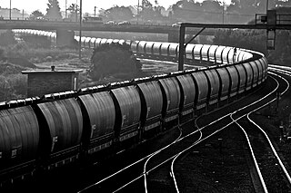
The Hunter Valley Coal Chain (HVCC) is the chain of coal delivery in New South Wales, Australia from coal mines in the Hunter Region to the Port of Newcastle and domestic coal-fired power stations in the Hunter Valley. The HVCC essentially follows the path of the Hunter River travelling south-east from the mining areas in the Hunter Valley to Newcastle.

Lake Bumbunga is a salt lake located in the Mid North of the state of South Australia, between the town of Lochiel and the farming locality of Bumbunga, approximately 1.5 hours' drive from Adelaide. It is a pink lake, with its colour due to certain algae.

The District Council of Grant is a local government area located in the Limestone Coast region of South Australia, and is the southernmost council in the state.

Fortescue is a global metal mining company headquartered in Australia. Fortescue focused on iron ore mining under the name of Fortescue Metals Group (FMG) until July 2023. As of 2017, Fortescue is the fourth-largest iron ore producer in the world. The company has holdings of more than 87,000 km2 in the Pilbara region of Western Australia, making it the largest tenement holder in the state, larger than both BHP and Rio Tinto.

Penong is a town and locality on the Nullarbor Plain, in the far west of the state of South Australia located about 616 kilometres (383 mi) north-west of the state capital of Adelaide. With no settlements between it and Border Village on the border with Western Australia, 400 km (250 mi) away on the Eyre Highway, it is a popular rest-stop for travellers.

One Rail Australia was an Australian rail freight operator company. Founded by a United States short line railroad holding company, Genesee & Wyoming Inc, in 1997 as Australian Southern Railroad, and successively renamed Australian Railroad Group and Genesee & Wyoming Australia, it was renamed One Rail Australia in February 2020 after the American company sold its remaining shareholding. In July 2022, assets from the South Australian, Northern Territory and interstate operations of the company were sold to rail operator company Aurizon Holdings Limited. The remaining assets, relating to coal haulage in New South Wales and Queensland, were sold in February 2023 to Magnetic Rail Group.

The Eyre Peninsula Railway is a 1,067 mm gauge railway on the Eyre Peninsula of South Australia. Radiating out from the ports at Port Lincoln and Thevenard, it is isolated from the rest of the South Australian railway network. It peaked at 777 kilometres in 1950; today only a 60 kilometre section remains open. It is currently operated by Aurizon.
This article describes the railway stations on the Eyre Peninsula of South Australia that were located on the lines of the Port Lincoln Division of the former South Australian Railways (SAR). Few of them were staffed. All stations were closed in 1968 when the SAR withdrew all passenger services.

Lisheen Mine is a former lead-zinc-silver mine located between the villages of Moyne and Templetuohy in County Tipperary, Ireland. In the Rathdowney Trend, Lisheen was an underground mine where the Lisheen deposit lies at an average depth of 170 metres below surface. The mine closed in 2015.

The Lüneburg Kalkberg is the cap rock of a salt dome in the western part of the German town of Lüneburg. The Kalkberg was a gypsum mine during the Middle Ages, but is today a Naturschutzgebiet and a common meeting place for city residents.
The Hope Downs mine is an iron ore mining complex located in the Pilbara region of Western Australia. It comprises four large open-pit mines. The mines are co-owned by the Hancock Group and Rio Tinto, and the complex was named after Hope Hancock.
The Roy Hill mine is an iron ore mine in the Chichester Range in the Pilbara region of Western Australia, located 115 kilometres (71 mi) north of Newman and 277 kilometres (172 mi) south of Port Hedland. With indicated and inferred reserves of more than 2.4 billion tonnes, it is expected to become one of the largest mining projects in Australia. Mining operations will produce 55 million tonnes of iron ore per annum with an operating life of more than 20 years.

Port Kembla is a man-made cargo port or artificial harbour, with an outer harbour protected by breakwaters and an inner harbour constructed by dredging, located in the Illawarra region of New South Wales, Australia. Activities within the port are managed by the Port Authority of New South Wales.

The 2300 class is a class of diesel locomotives rebuilt by Queensland Rail's Redbank Railway Workshops between 1997 and 2002.

The Mtwara Development Project is a major infrastructure development project involving southern Tanzania, northern Mozambique, eastern Malawi and Eastern Zambia. The goal of this project is to provide road, rail and waterway access from the surrounding region to the Port of Mtwara. The region and the corridor has been neglected by the respective governments for over 40 years and the recent discovery of oil, gas and various minerals has kick started the development of the project. A road and rail link is to be built from the port of Mtwara to Mbamba Bay on Lake Nyasa to link Malawi to the corridor and further road links into Mozambique will facilitate access to northern Mozambique.


