Lake Mackay

Last updated

Lake Mackay
(Wilkinkarra)
Wilkinkarra (Pintupi-Luritja)
Lake mackay.jpg
From space (November 1989)
Australia relief map.jpg
Red pog.svg
Lake Mackay
(Wilkinkarra)
Location on the Northern Territory and Western Australian border
Location Western Australia and Northern Territory
Coordinates 22°30′S128°35′E / 22.500°S 128.583°E / -22.500; 128.583
Type Salt lake
Basin  countriesAustralia
Max. length100 km (62 mi)
Max. width100 km (62 mi)
Surface area3,494 km2 (1,349 sq mi)
Lake Mackay

Lake Mackay, known as Wilkinkarra to the Indigenous Pintupi people, is the largest of hundreds of ephemeral salt lakes scattered throughout the Pilbara and northern parts of the Goldfields-Esperance region of Western Australia [1] and the Northern Territory. It is located on the edge of the Great Sandy Desert.

Contents

The lake is the largest in Western Australia and has a surface area of 3,494 square kilometres (1,349 sq mi). [2] Its elevation ranges between 355 m (1,165 ft) and 370 m (1,210 ft) above mean sea-level. [3]

Description

Lake Mackay is the fourth largest lake in Australia. [4] It measures approximately 100 kilometres (60 mi) east-west and north-south. The darker areas of the lakebed are indicative of some form of desert vegetation or algae, some moisture within the soils of the dry lake, and the lowest elevations where pooling of water occurs. In this arid environment, salts and other minerals are carried to the surface through capillary action caused by evaporation, thereby producing the white reflective surface. Visible are various brown hills scattered across the eastern half of the lake and east-west-oriented sand ridges south of the lake.

Encounters

Explorer David Carnegie in 1897 predicted the lake's existence when he passed by it to the west as quoted in his book Spinifex and Sand. [5]

May 9th we left the well on a Southerly course, and were soon amongst the ridges, which continued for the next two days. The night of the 11th, having skirted a line of rough cliffs, we camped about three miles North of a very prominent single hill, which I named Mount Webb, after W. F. Webb, Esq., of Newstead Abbey, Nottinghamshire. As the sun rose that morning the mirage of a lake of apparently great size was visible for 90° of the horizon — that is, from East round to South. Neither from the cliffs that we skirted, nor from Mount Webb, was any lake visible, but it is more than probable that a large salt lake exists in this locality, possibly connecting, in a broken line, Lake White and Lake Macdonald.[ citation needed ]

The lake was first charted by Christopher Walker. He and Andy Everett came upon the mid-eastern side on Tuesday 15 April 1913, while on a prospecting expedition west from Ryan's Well to Wiluna.

Looking westward all that I could see was mirage for miles which appeared like large sheets of water. … After leaving the hill & going west for two miles we struck on our right an arm of the lake. At this point the lake was dry & exposed a thin layer of very white salt. … We then followed the arm of the lake westward. In another two miles along the arm it wheeled around to the south. … From this position looking north at what first looked like land on the other side, was only an island in the lake. Going a little further south gave us a better view of the islands. These islands would be distant from near shore from one up to four miles. Looking westward between the islands the lake could plainly be seen for many miles westward. This part of the lake we could not see water only large salt plains, which had the appearance of a large plain after a snow storm. [6]

It was next reported by the 1930 Mackay Aerial Survey Expedition, after the survey aircraft flew over on 5 June 1930. Then Michael Terry and party reached the north-eastern corner of Lake Mackay by camel in August 1932. [7] Terry mentioned two reports which may have been of the same lake, prior to Mackay’s 1930 survey: Afghan cameleer Rawazan in 1904, and the prospector Jimmy Wyckham in 1925. [6]

Lake Mackay was approved as a name both in the Northern Territory and in Western Australia by the Minister for the Interior, Canberra, on 13 March 1934 [8] after Donald George Mackay.

Events

The lake was the birthplace of prominent Indigenous artist Linda Syddick Napaltjarri, [9] and the area in which artist Ronnie Tjampitjinpa grew up. [10]

Namesakes

The Northern Territory locality of Lake Mackay, whose boundaries include the lake, was named after it in 2007. [11]

Mackay Lacus, one of the lakes on Saturn's moon Titan, is named after Lake Mackay. [12]

See also

Related Research Articles

<span class="mw-page-title-main">Simpson Desert</span> Desert in Central Australia

The Simpson Desert is a large area of dry, red sandy plain and dunes in the Northern Territory, South Australia and Queensland in central Australia. It is the fourth-largest Australian desert, with an area of 176,500 km2 (68,100 sq mi).

<span class="mw-page-title-main">Great Salt Lake Desert</span> Large dry lake in northern Utah, United States

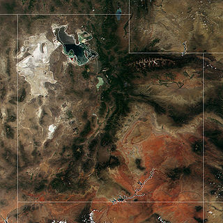
The Great Salt Lake Desert is a large dry lake in northern Utah, United States, between the Great Salt Lake and the Nevada border. It is a subregion of the larger Great Basin Desert, and noted for white evaporite Lake Bonneville salt deposits including the Bonneville Salt Flats.

<span class="mw-page-title-main">David Carnegie (explorer)</span> English explorer in Western Australia

The Hon. David Wynford Carnegie was an explorer and gold prospector in Western Australia. In 1896 he led an expedition from Coolgardie through the Gibson and Great Sandy Deserts to Halls Creek, and then back again.

<span class="mw-page-title-main">Lake Amadeus</span> Lake in Northern Territory in Australia

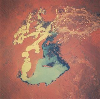
Lake Amadeus is a large salt lake in the southwest corner of Northern Territory of Australia, about 50 kilometres (31 mi) north of Uluru. The smaller Lake Neale is adjacent to the northwest. It is part of the Amadeus Basin that was filled with the erosion products of the Petermann Orogeny.

Kintore is a remote settlement in the Kintore Range of the Northern Territory of Australia about 530 km (330 mi) west of Alice Springs and 40 km (25 mi) from the border with Western Australia. It is also known as Walungurru, Walangkura, and Walangura.

<span class="mw-page-title-main">Lake Gregory (Western Australia)</span> Lake in Western Australia

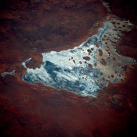
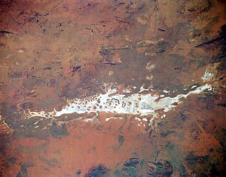
Lake Gregory, or Paraku in the Walmajarri language, is a permanent brackish lake located in the Kimberley region of Western Australia, situated between the Great Sandy Desert and the Tanami Desert. Following monsoonal rains it may hold fresh water, but becomes more saline after a number of dry years.

<span class="mw-page-title-main">Lake Gairdner</span> Salt lake in South Australia

Lake Gairdner is a large endorheic salt lake in the Australian state of South Australia, to the north of the Eyre Peninsula. When in flood, the lake is considered the third largest salt lake in Australia.

<span class="mw-page-title-main">Deserts of Australia</span> Deserts in Australia

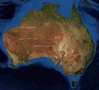
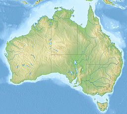
The deserts of Australia or the Australian deserts cover about 2,700,000 km2 (1,000,000 sq mi), or 18% of the Australian mainland, but about 35% of the Australian continent receives so little rain, it is practically desert. Collectively known as the Great Australian desert, they are primarily distributed throughout the Western Plateau and interior lowlands of the country, covering areas from South West Queensland, Far West region of New South Wales, Sunraysia in Victoria and Spencer Gulf in South Australia to the Barkly Tableland in Northern Territory and the Kimberley region in Western Australia.

The Lake Mackay hare-wallaby, also known as the central hare-wallaby or kuluwarri, is an extinct species of macropod formerly found in central Australia. Very little is known about it.

<span class="mw-page-title-main">Geography of South Australia</span>

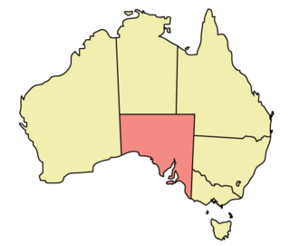
The geography of South Australia incorporates the south central part of the continent of Australia. It is one of the six states of Australia. South Australia is bordered on the west by Western Australia, to the north by the Northern Territory, Queensland to the northeast, and both New South Wales and Victoria to the east. South Australia's south coast is flanked by the Great Australian Bight and the Southern Ocean.

Donald George Mackay CBE was an Australian outdoorsman, long-distance cyclist, and explorer who conducted several expeditions to the remotest areas of the Australian continent.

<span class="mw-page-title-main">Lake Breaden</span> Salt lake in Gibson Desert, Western Australia

Lake Breaden is a salt lake in the Gibson Desert of Western Australia, to the northeast of Boyd Lagoon. It covers an area of roughly 2,600 hectares and has a surface elevation of 395 metres (1,296 ft) above sea level.

The Kelly Hills are a mountain range at the southern end of the Northern Territory of Australia. It is located in the locality of Petermann directly north of the Musgrave Ranges and about 50 kilometres (31 mi) northeast of Amaṯa in South Australia. Its highest point is about 870 metres (2,850 ft) above sea level. Mount Robert, at the eastern end of the range, is about 796 metres (2,612 ft) above sea level. The area is known as Aputjilpinya in the native Yankunytjatjara language. It forms part of an important Mala Dreaming track that runs between Uluṟu and Ulkiya.

<span class="mw-page-title-main">Serpentine Lakes</span> Chain of salt lakes in South Australia

The Serpentine Lakes is a chain of salt lakes in the Great Victoria Desert of Australia. It runs for almost 100 km (62 mi) along the border between South Australia and Western Australia. When full, the lakes cover an area of 9,700 hectares (97 km2). Most of it is located in the Mamungari Conservation Park. The Anne Beadell Highway crosses the northernmost arm of the lake.

<span class="mw-page-title-main">Lake Dey Dey</span> Salt lake in South Australia

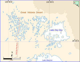
Lake Dey Dey is one of many ephemeral salt lakes located in the eastern end of the Great Victoria Desert, in the Far North region of South Australia.

<span class="mw-page-title-main">Carle Thulka</span> Salt lake in South Australia

Carle Thulka, officially Carle Thulka / Lake Maurice is a salt lake in South Australia. It is the largest of many salt lakes in the eastern end of the Great Victoria Desert. It is normally dry, except during and after periods of heavy rainfall. When it is full, the lake covers an area of around 2,900 hectares (29 km2). It is part of the geological basin known as the Officer Basin. The smaller Lake Dey Dey is to the north. Since 1985, Carle Thulka is part of the lands belonging to the Maralinga Tjarutja, a southern branch of the Pitjantjatjara. The community of Oak Valley is near the western shore of the lake.

<span class="mw-page-title-main">Percival Lakes</span> Lakes in Western Australia

The Percival Lakes form a string of S-shaped ephemeral salt lakes in the north of Western Australia. They lie at the southern region of the Great Sandy Desert and east of Karlamilyi National Park. They stretch in an east-west direction for 350 km (220 mi) and north-south for 160 km (99 mi). The surface elevation is 256 m (840 ft). The Canning Stock Route runs in close proximity to some of the lakes, and crosses the salt pan of Tobin Lake near the eastern end. The lakes were named during the aerial expedition of Donald George Mackay in 1933, after the designer of the Percival Gull aircraft being used.

<span class="mw-page-title-main">Lake Wells</span> Lake in Western Australia

Lake Wells is an ephemeral salt lake in the centre of Western Australia, lying in close proximity to Lake Carnegie. It lies east of Wiluna and is at the southern edge of the Little Sandy Desert and south western border of the Gibson Desert. It also lies to the north west of the Great Central Road and the Great Victoria Desert. Its surface elevation is 436 metres above mean sea-level. Lake Wells has an area of 1895 square kilometres.

<span class="mw-page-title-main">Carnegie expedition of 1896</span> Western Australian exploration in 1896

The Carnegie expedition of 1896 was led by David Carnegie. It covered territory in the centre of Western Australia, including the Gibson and Great Sandy Deserts.

References

  1. "Largest Waterbodies". Geoscience Australia. 15 May 2014. Retrieved 15 March 2015.
  2. "Australian Geoscience - Largest Waterbodies". 2009. Archived from the original on 26 February 2009. Retrieved 7 March 2009.
  3. Geoscience Australia elevation data portal
  4. Northern Territory Department of Land Resource Management, Information Page - Lake Mackay Archived 21 March 2015 at the Wayback Machine
  5. "Spinifex and Sand".
  6. 1 2 Long, Jeremy; Nash, David, eds. (2022). "Appendix 4: Lake Mackay". Diary -- Walker Bros Prospecting Expedition 1913. Carlisle, WA: Hesperian Press. pp. 123–132. ISBN   978-0-85905-727-1.
  7. 21 August 1932 entry, camp 35. Log of Michael Terry leader of the Emu Mining Company expedition 1932. Transcribed by Brian A. Rutherford, 5 November 1994. SA Museum Archives AA 333/6/4 A-C. http://archives.samuseum.sa.gov.au/aa333/AA%20333-06.htm
  8. Department of Lands Planning and the Environment, Northern Territory Government. "Lake Mackay". NT Place Names Register. Retrieved 2 May 2023.
  9. Birnberg, Margo; Janusz Kreczmanski (2004). Aboriginal Artist Dictionary of Biographies: Australian Western, Central Desert and Kimberley Region. Marleston, South Australia: J.B. Publishing. p. 216. ISBN   1-876622-47-4.
  10. McCulloch, Alan; Susan McCulloch; Emily McCulloch Childs (2006). The new McCulloch's Encyclopedia of Australian Art. Fitzroy, Victoria: Aus Art Editions in association with The Miegunyah Press. p. 159. ISBN   0-522-85317-X.
  11. "Place Names Register Extract for Lake Mackay (locality)". NT Place Names Register. Northern Territory Government. Retrieved 13 January 2020.
  12. "Mackay Lacus". USGS planetary nomenclature page]. USGS . Retrieved 28 December 2013.