
Taupō, sometimes spelled Taupo, is a town on the north-eastern shore of Lake Taupo in the central North Island of New Zealand. The town is the largest urban area and the seat of the Taupo District, and the second-largest urban area in the Waikato region behind Hamilton.

The Waikato River is the longest river in New Zealand, running for 425 kilometres (264 mi) through the North Island. It rises in the eastern slopes of Mount Ruapehu, joining the Tongariro River system and flowing through Lake Taupo, New Zealand's largest lake. It then drains Taupo at the lake's northeastern edge, creates the Huka Falls, and flows northwest through the Waikato Plains. It empties into the Tasman Sea south of Auckland, at Port Waikato. It gives its name to the Waikato region that surrounds the Waikato Plains. The present course of the river was largely formed about 17,000 years ago. Contributing factors were climate warming, forest being reestablished in the river headwaters and the deepening, rather than widening, of the existing river channel. The channel was gradually eroded as far up river as Piarere, leaving the old Hinuera channel through the Hinuera Gap high and dry. The remains of the old river path can be clearly seen at Hinuera where the cliffs mark the ancient river edges. The river's main tributary is the Waipa River, which has its confluence with the Waikato at Ngāruawāhia.

The Taupō Volcanic Zone (TVZ) is a volcanic area in the North Island of New Zealand that has been active for the past two million years and is still highly active. Mount Ruapehu marks its south-western end and the zone runs north-eastward through the Taupo and Rotorua areas and offshore into the Bay of Plenty. It is part of the larger Central Volcanic Region that extends further westward through the western Bay of Plenty to the eastern side of the Coromandel Peninsula and has been active for four million years. The Taupo Volcanic Zone is widening east–west at the rate of about 8 mm per year. It is named after Lake Taupo, the flooded caldera of the largest volcano in the zone, the Taupo Volcano.

The Auckland Region is one of the sixteen regions of New Zealand, named for the city of Auckland, the country's largest urban area. The region encompasses the Auckland metropolitan area, smaller towns, rural areas, and the islands of the Hauraki Gulf. Containing 34 percent of the nation's residents, it has by far the largest population and economy of any region of New Zealand, but the second-smallest land area.

Lake Karapiro is an artificial reservoir lake on the Waikato River, 30 kilometres (19 mi) south-east of the city of Hamilton at Karapiro in New Zealand's North Island. The lake was formed in 1947 by damming the Waikato River to store water for the 96-megawatt Karapiro hydroelectric power station.

Mangakino is a small town on the banks of the Waikato River in the North Island of New Zealand. It is located close to the hydroelectric power station at Lake Maraetai, 85 kilometres (53 mi) southeast of Hamilton. Its population in 2001 was 1257. The town and its infrastructure are administered as the Mangakino Pouakani ward by the Taupo District Council

Ohakuri is a dam and hydroelectric power station on the Waikato River, central North Island, New Zealand, midway between Taupo, Rotorua and Hamilton. Its dam is about 5 kilometres (3.1 mi) upstream of the Atiamuri Dam.

State Highway 30 (SH 30) is a New Zealand state highway, linking the Waikato and Bay of Plenty towns of Te Kuiti, Mangakino, Rotorua, and Whakatane.
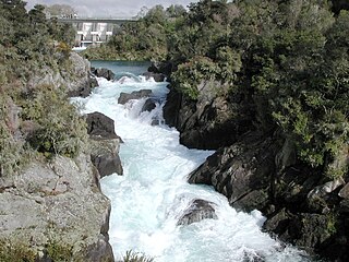
Aratiatia Power Station is a hydroelectric power station on the Waikato River, in the North Island of New Zealand. It is the first hydroelectric power station on the Waikato River, and is located 13 kilometres (8.1 mi) downstream of Lake Taupo. Aratiatia is owned and operated by Mercury Energy.

The Karapiro Power Station is a hydroelectric power station at Karapiro on the Waikato River, in the North Island of New Zealand. The power station lies on Lake Karapiro, a major rowing regatta venue. Karapiro is 30 kilometres (19 mi) south-east and upstream from the city of Hamilton and several kilometres from Cambridge. It is the last of the eight hydroelectric power stations on the Waikato River.
The Tongariro Power Scheme is a 360 MW hydroelectricity scheme in the central North Island of New Zealand. The scheme is currently operated by electricity generation company Genesis Energy.

Maraetai Power Station is a hydroelectric power station on the Waikato River, in the North Island of New Zealand. It is the fifth of the eight hydroelectric power stations on the Waikato River, and at 360 MW, is the largest hydroelectric station on the Waikato.

Arapuni Power Station is a hydroelectric power station on the Waikato River, in the North Island of New Zealand. It is owned and operated by Mercury Energy, and is the seventh and penultimate hydroelectric power station on the Waikato River. It is also the oldest currently generating, the first government-built, and the largest capacity single hydroelectric power station on the Waikato River. The two power houses that make up the Maraetai Power Station have a larger combined capacity however.
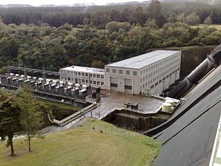
Whakamaru Power Station is a hydroelectric power station on the Waikato River, in the North Island of New Zealand. It is the fourth hydroelectric power station on the Waikato River.

The Arapuni Suspension Bridge is located just downstream from the Arapuni Power Station on the Waikato River in the South Waikato District of New Zealand. The 152-metre (499 ft) suspension bridge in the bush-lined gorge was built in the mid-1920s to allow workers from the village of Arapuni to access the power station construction site.

The Waikato River Trails is a combined walk- and cycleway along the Waikato River. Originally conceived and started by local politicians and trustees, in 2009 the trails became one of the seven Quick Start Projects that form the beginning of the New Zealand Cycle Trail. The trail is proposed to be 100 km long, out of which 50 km existed before the NZCT scheme was created. In mid-2011, work on the last sections of the cycle trail project sections was begun, while the official grand opening occurred early November 2011.
Maraetai is a small satellite town east of Auckland, New Zealand. It may also refer to:
State Highway 32 (SH 32) is a New Zealand state highway in the Central North Island. It forms part of a western traverse of Lake Taupo and a less busy alternative to SH 1, avoiding Taupo.
The Mangakino Stream is a tributary of the Waikato River. It flows into Lake Maraetai just upstream of the Mangakino township.


