
The Great Victoria Desert is a sparsely populated desert ecoregion and interim Australian bioregion in Western Australia and South Australia.

The Simpson Desert is a large area of dry, red sandy plain and dunes in the Northern Territory, South Australia and Queensland in central Australia. It is the fourth-largest Australian desert, with an area of 176,500 km2 (68,100 sq mi).

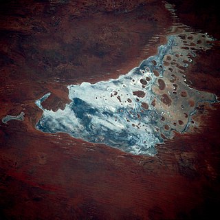
Kumpupintil Lake, formerly known as Lake Disappointment, is an endorheic salt lake located in the Little Sandy Desert, east of the Pilbara region of Western Australia.
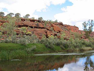
The Finke River, or Larapinta in the Indigenous Arrernte language, is a river in central Australia, whose bed courses through the Northern Territory and the state of South Australia. It is one of four main rivers of the Lake Eyre Basin and thought to be the oldest riverbed in the world. It flows for only a few days a year. When this happens, its water usually disappears into the sands of the Simpson Desert, rarely if ever reaching Lake Eyre.

The Vulkathunha-Gammon Ranges National Park is a protected area in the Flinders Ranges of South Australia, immediately south-west of and adjacent to the Arkaroola Protection Area. They encompass some of the most rugged and spectacular country in South Australia.
Lake Amadeus is a large salt lake in the southwest corner of Northern Territory of Australia, about 50 kilometres (31 mi) north of Uluru. The smaller Lake Neale is adjacent to the northwest. It is part of the Amadeus Basin that was filled with the erosion products of the Petermann Orogeny.
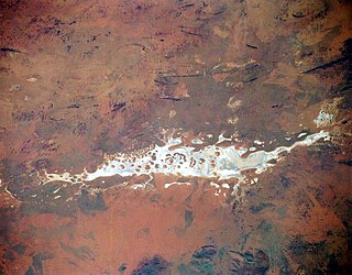
Lake Mackay, known as Wilkinkarra to the Indigenous Pintupi people, is the largest of hundreds of ephemeral salt lakes scattered throughout the Pilbara and northern parts of the Goldfields-Esperance region of Western Australia and the Northern Territory. It is located on the edge of the Great Sandy Desert.
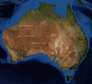
The deserts of Australia or the Australian deserts cover about 2,700,000 km2 (1,000,000 sq mi), or 18% of the Australian mainland, but about 35% of the Australian continent receives so little rain, it is practically desert. Collectively known as the Great Australian desert, they are primarily distributed throughout the Western Plateau and interior lowlands of the country, covering areas from South West Queensland, Far West region of New South Wales, Sunraysia in Victoria and Spencer Gulf in South Australia to the Barkly Tableland in Northern Territory and the Kimberley region in Western Australia.
Newhaven Wildlife Sanctuary, once a cattle station known as Newhaven Station is an Australian nature reserve. It lies around 300–400 kilometres (186–249 mi) north-west of Alice Springs in the Northern Territory of Australia. It is jointly operated by Birds Australia and the Australian Wildlife Conservancy.
The Amadeus Basin is a large (~170,000 km2) intracratonic sedimentary basin in central Australia, lying mostly within the southern Northern Territory, but extending into the state of Western Australia.
The Nambung River is a river in the Wheatbelt region of Western Australia, 170 kilometres (106 mi) north of Perth. The river drains an area between the towns of Cervantes and Badgingarra. In its lower reaches the Nambung River forms a chain of waterholes in the Nambung Wetlands where it disappears underground into a limestone karst system 5.5 kilometres (3 mi) from the Indian Ocean.

Neale Junction is an isolated location in the Great Victoria Desert of Western Australia, where the Anne Beadell and Connie Sue Highways intersect. It is 172 km (107 mi) west of Ilkurlka. Neale Junction was named after Commander Frank Neale, who flew a Percival Gull through the area during the Mackay Aerial Reconnaissance Survey Expedition to Western and South Australia in 1935.
Donald George Mackay CBE was an Australian outdoorsman, long-distance cyclist, and explorer who conducted several expeditions to the remotest areas of the Australian continent.
Lake Newland Conservation Park is a protected area in the Australian state of South Australia located on the west coast of the Eyre Peninsula about 10 kilometres (6.2 mi) north of the town of Elliston. It was proclaimed in 1991 in order to protect Lake Newland, a hypersaline lake, and an associated wetland complex. It lies in the traditional lands of the Wirangu people.
The Kelly Hills are a mountain range at the southern end of the Northern Territory of Australia. It is located in the locality of Petermann directly north of the Musgrave Ranges and about 50 kilometres (31 mi) northeast of Amaṯa in South Australia. Its highest point is about 870 metres (2,850 ft) above sea level. Mount Robert, at the eastern end of the range, is about 796 metres (2,612 ft) above sea level. The area is known as Aputjilpinya in the native Yankunytjatjara language. It forms part of an important Mala Dreaming track that runs between Uluṟu and Ulkiya.
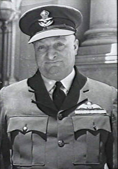
Frank Neale, AFC was a British-born Australian aviator. Born in England, he served in the Royal Flying Corps and the Royal Air Force during the First World War, then moved to Australia in the mid-1920s to continue a notable career as a pioneer aviator. From 1925 until 1939 he flew thousands of hours covering most of Australia, and ventured overseas a number of times. At the outbreak of the Second World War he joined the Royal Australian Air Force Reserve, rising to wing commander and being awarded the Air Force Cross prior to his discharge in 1946.
Mount Unapproachable is an isolated mountain in the Northern Territory of Australia located in the locality of Petermann on the northern side of Lake Neale in the territory's southwest. It is about 505 metres (1,657 ft) above sea level. The area is remote: the nearest towns are Kaltukatjara some 116 kilometres (72 mi) away, Kintore some 135 kilometres (84 mi) away and Yulara 138 kilometres (86 mi) away. The mountain is mostly made of sandstone.

Lake Hopkins is a salt lake in the east of Western Australia very close to the Northern Territory border. It is located to the west of Lake Neale, which together with Lake Amadeus forms part of a chain of salt lakes that stretches about 500 km (310 mi), from Lake Hopkins in the west to the Finke River in the east. This drainage basin is known as the Amadeus Basin. The lake is usually a dry salt pan, and only holds water for short periods after heavy rainfall. Lake Hopkins has an elevation of 441 metres above mean sea level. The lake proved to be quite an obstacle to progress for Len Beadell during construction of the Sandy Blight Junction Road in 1960.
The Katiti Aboriginal Land Trust is a land trust for a block of land in the southwest of the Northern Territory of Australia located in the locality of Petermann. It was created through the Katiti Land Claim in 1980. The trust's owners include Pitjantjatjara, Yankunytjatjara and Luritja people. The block of land is officially referred to as Northern Territory Portion 1818. It borders the larger Petermann Land Trust area and Uluṟu–Kata Tjuṯa National Park to the north and west, and two pastoral stations to the east and south: Curtin Springs and Mulga Park. The town of Yulara is excluded from the Land Trusts, and sits between the Katiti block and Uluṟu–Kata Tjuṯa National Park.

