The lake was created in 1925 by the Palisades Interstate Park Commission under William A. Welch by building a dam across Stony Brook. The lake filled the former site of Johnsontown—a logging settlement founded in the mid-1700s in the Stony Brook valley.[2] By the early 1900s, Johnsontown was the largest mountain settlement in the western part of the Ramapos.[citation needed]
In 1916–1917, the PIPC condemned the land on the grounds that the settlement was built on swampland ("the great Emmetfield Swamp"). Many homeowners resettled in nearby Sloatsburg. The PIPC took possession of the land and the homes, stores, school and church were torn down before the Stony Brook valley was flooded to create the new lake. Remnants of the Johnsontown sawmill are still visible to scuba divers.
Activities
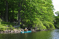
The Lake, which is operated by the Palisades Interstate Park Commission, is surrounded by picnic lawns and play fields, and is popular with anglers fishing for bass, perch and sunfish. The lake has a hand boat launch and cabin camping.
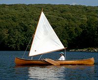
The American Canoe Association and the New York chapter of the Adirondack Mountain Club have camps on the lake. The latter is named "Nawakwa",[3] and dates to 1926, while the former, originally built for the Rogers Peet Company, was built in 1928 and was taken over by the ACA in 1933.
In 1927, a camp was built for the employees of four New York City banks. In 1986, the camp was turned over to a concessionaire to offer cabin camping to the public. Also in 1927, New York University opened a camp which they used until 1961; its facilities, too, are presently available to the public.[citation needed]
In 2021, Tentrr opened camping sights at the lake.[4]
Beach closing
On August 27, 2011, Hurricane Irene passed over southern New York leaving the New Sebago Beach ruined and forcing its indefinite closure. The following year, on October 29, 2012, Hurricane Sandy devastated the picnic area around the beach forcing the rest of the park to close. Although two other swimming areas remain open, efforts continued in 2021 to reopen New Sebago Beach.[5]
Rockland County is the southernmost county on the west side of the Hudson River in the U.S. state of New York. It is part of the New York metropolitan area. As of the 2020 U.S. census, the county's population is 338,329, making it the state's third-most densely populated county outside New York City after Nassau and neighboring Westchester Counties. The county seat and largest hamlet is New City. Rockland County is accessible via both the New York State Thruway, which crosses the Hudson River to Westchester via the Tappan Zee Bridge over the Tappan Zee, ten exits up from the NYC border; and the Palisades Parkway, four exits up, via the George Washington Bridge. The county's name derives from "rocky land", as the area has been aptly described, largely due to the Hudson River Palisades. The county is part of the Hudson Valley region of the state.
Tuxedo is a town located in Orange County, New York, United States, along the Ramapo River. As of the 2020 census, the town had a total population of 3,811. The town is in the southeastern part of the county in the Ramapo Mountains. New York State Route 17 and the New York State Thruway pass through the town. The name is derived from a Lenape word tucseto, which has several known meanings.
The Palisades Interstate Parkway (PIP) is a 38.25-mile (61.56 km) controlled-access parkway in the U.S. states of New Jersey and New York. The parkway is a major commuter route into New York City from Rockland and Orange counties in New York and Bergen County in New Jersey. The southern terminus of the route is at the George Washington Bridge in Fort Lee, New Jersey, where it connects to Interstate 95 (I-95), US 1-9, and US 46. Its northern terminus is at a traffic circle in Fort Montgomery, New York, where the PIP meets US 9W and US 202 at the Bear Mountain Bridge. At exit 18, the PIP forms a concurrency with US 6 for the remaining duration of its run.
Bear Mountain State Park is a 5,205-acre (21.06 km2) state park located on the west bank of the Hudson River in Rockland and Orange counties, New York. The park offers biking, hiking, boating, picnicking, swimming, cross-country skiing, cross-country running, sledding and ice skating. It also includes several facilities such as the Perkins Memorial Tower, the Trailside Museum and Zoo, the Bear Mountain Inn, a merry-go-round, a pool, and a skating rink. It also hosts the Bear Mountain Circle, where the historic Palisades Interstate Parkway and Bear Mountain Bridge meet. It is managed by the Palisades Interstate Park Commission, which is overseen by the State of New York.
At 47,527 acres (192.33 km2), Harriman State Park is the second largest state park in the U.S. state of New York. Located in Rockland and Orange counties 30 miles (48 km) north of New York City, it is a haven for hikers with over 200 miles (320 km) of hiking trails. The park is also known for its 31 lakes, multiple streams, public camping area, and great vistas. The park's hiking trails are currently maintained by volunteers from the New York - New Jersey Trail Conference.
The Palisades Interstate Park Commission (PIPC) was formed in 1900 by Governors Theodore Roosevelt of New York and Foster Voorhees of New Jersey in response to the quarrying operations along the Palisades Cliffs of New Jersey. The Palisades, a National Natural Landmark that are also called the New Jersey Palisades or the Hudson River Palisades, are a line of steep cliffs along the west side of the lower Hudson River in Northeastern New Jersey and Southeastern New York in the United States. After its formation, the PIPC quickly moved to acquire the lands at the base of the Palisades to stop quarrying operations in both New York and New Jersey. The commission consists of ten commissioners, five appointed by each governor, and was ratified by an Act of Congress in 1937 when its interstate compact was approved. Today, the Commission owns and operates more than 125,000 acres of public parkland in New York and New Jersey including 21 state parks, 8 historic sites, and the Palisades Interstate Parkway. These parks are visited by more than 7 million people annually.
Doodletown was an isolated hamlet in the Town of Stony Point, Rockland County, New York, United States. Purchased by the Palisades Interstate Park Commission during the 1960s, it is now part of Bear Mountain State Park and a popular destination for hikers, birdwatchers, botanists, and local historians. It is located north of Jones Point, west of Iona Island, and southeast of Orange County. The former settlement is now a ghost town.
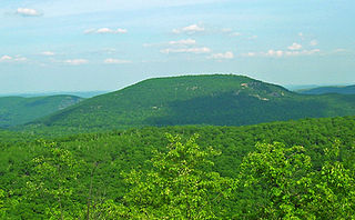
Bear Mountain is one of the best-known peaks of New York's Hudson Highlands. Located partially in Orange County in the town of Highlands and partially in Rockland County in the town of Stony Point, it lends its name to the nearby Bear Mountain Bridge and Bear Mountain State Park that contains it.
County Route 106 (CR 106) is a 7.8-mile (12.6 km) east–west county route in Rockland County, New York, in the United States. It serves as an eastward continuation of Kanawauke Road, extending from the Orange County line to U.S. Route 9W (US 9W) and US 202 in Stony Point via Harriman State Park. CR 106 intersects with several county highways in Rockland County along the way. The route was only one of two in Rockland County to keep its numbering from Orange County, with the other being CR 72. CR 106 had one spur route, CR 106A, which was recently decommissioned.
Seven Lakes Drive is a north–south parkway located in the Hudson Valley region of New York in the United States. It extends for just under 18 miles (29 km) on a northeast–southwest alignment from an intersection with New York State Route 17 (NY 17) in the village of Sloatsburg to a junction with U.S. Route 9W (US 9W) and US 202 south of the Bear Mountain Bridge in the town of Stony Point. Most of the parkway is located in either Harriman or Bear Mountain state parks, except for a small stretch near its southern end. Ownership of Seven Lakes Drive is split between three entities, two of which are also responsible for maintenance of the road.
Lake Kanawauke is a primarily human-made lake in Harriman State Park. The name is Onondaga in origin, and means "place of much water". There are three parts to the lake, lower, middle and upper; the total area is 186 acres (0.75 km2). It is located in the Town of Tuxedo in Orange County and the Town of Haverstraw in Rockland County, both residing within the state of New York.
Pine Meadow Lake is a 72-acre (0.29 km2) lake in Rockland County, New York. It is found at an elevation of 974 feet (297 m). It is located at the end of the 5.5-mile (8.9 km) Pine Meadow Trail in Harriman State Park.
Arden Valley Road is an east-west parkway located in Southfields, New York, in the United States, that travels through Harriman State Park and is owned by the Palisades Interstate Park Commission. At 5.2 miles (8.4 km) long, it begins at New York State Route 17 (NY 17) in Southfields and ends at Seven Lakes Drive in Harriman State Park. Arden Valley Road also serves a trout stocking area for the Ramapo River. The road is located entirely in Orange County and is home to the Elk's Pen Trailhead in Harriman State Park. In 1921, plans arose by the commission to construct the road, which was completed the same year and stretched along the borderline with the Harriman estate. Major William A. Welch ordered 75 elk from Yellowstone National Park to be placed in a wired cage between Arden and Southfields in 1919. The elk eventually disappeared from the pen by 1942, and the area became the current Elk's Pen trailhead for trails within Harriman State Park.
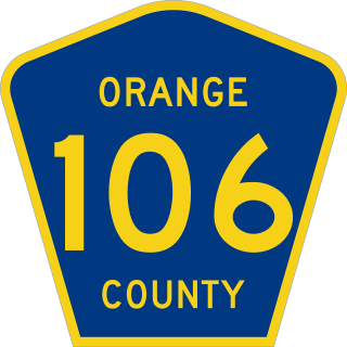
County Route 106 (CR 106) in the county of Orange County, New York, was a continuation of two routes, New York State Route 17A (NY 17A) at its western terminus and Rockland CR 106 at the eastern terminus. Route 106 began at an intersection with NY 17A and its parent route, NY 17 in Southfields, where CR 106 signs are still posted according to the August 2018 Google Street View images. The route went eastward through Harriman State Park, crossing Seven Lakes Drive before entering nearby Rockland County, New York. There it became Rockland County Route 106 and heads all the way to Stony Point.
Sandyfield was a settlement of about 30 houses in the Town of Ramapo in Rockland County, New York, United States, that was submerged in 1928 when swampy Beaver Pond was dammed to create Lake Welch in Harriman State Park.
Johnsontown is a former hamlet in the town of Stony Point in Rockland County, New York, United States.
The recorded history of Rockland County, New York begins on February 23, 1798, when the county was split off from Orange County, New York and formed as its own administrative division of the state of New York. It is located 6 miles (9.7 km) north-northwest of New York City, and is part of the New York Metropolitan Area. The county seat is the hamlet of New City. The name comes from rocky land, an early description of the area given by settlers. Rockland is New York's southernmost county west of the Hudson River. It is suburban in nature, with a considerable amount of scenic designated parkland. Rockland County does not border any of the New York City boroughs, but is only 9.5 miles (15.3 km) north of Manhattan at the counties' two respective closest points
The Lake Welch Parkway, sometimes labeled Lake Welch Drive, is a limited-access parkway located within Harriman State Park in southern New York in the United States. It extends for 5.60 miles (9.01 km) on a southwest–northeast alignment from an intersection with Seven Lakes Drive to a partial interchange with the Palisades Interstate Parkway. The highway is located entirely in Rockland County, although it runs close to the border with Orange County. It is inventoried by the New York State Department of Transportation as New York State Route 987A, an unsigned reference route; however, it is owned by the Palisades Interstate Park Commission. The portion of the Lake Welch Parkway that lies south of Tiorati Brook Road is closed during the winter. The parkway is the main route to access all beaches in Harriman State Park: Lake Welch, Lake Tiorati, and Lake Sebago.
Tiorati Brook Road is an east-west parkway located within Harriman State Park in southern New York in the United States. The highway extends for 3.6 miles (5.8 km) between Tiorati Circle, a traffic circle connecting Tiorati Brook Road to Seven Lakes Drive in Orange County, and an interchange with the Lake Welch Parkway just west of where that parkway ends at the Palisades Interstate Parkway in Rockland County. The road crosses over the county line roughly midway between the two locations. Tiorati Brook Road is owned and maintained by the Palisades Interstate Park Commission.
Lake Tiorati is one of the seven main lakes in Harriman State Park, located in Orange County, New York. It is a man-made lake, created by dredging swampland and constructing a concrete dam. The name Tiorati means "Blue like Sky". Its name is the Algonquin word for "sky-like".
This page is based on this Wikipedia article Text is available under the CC BY-SA 4.0 license; additional terms may apply. Images, videos and audio are available under their respective licenses.