
Minnehaha County is a county on the eastern border of the state of South Dakota. As of the 2020 census, the population was 197,214, making it the state's most populous county. It contains over 20% of the state's population. Its county seat is Sioux Falls, South Dakota's most populous city. The county was created in 1862 and organized in 1868. Its name was derived from the Sioux word Mnihaha, meaning "rapid water," or "waterfall".

Vernon Township is a township in Sussex County, in the U.S. state of New Jersey. It is located about a one hour drive from New York City and is part of the New York Metropolitan Area. As of the 2020 United States census, the township's population was 22,358, a decrease of 1,585 (−6.6%) from the 2010 census count of 23,943, which in turn reflected a decline of 743 (−3.0%) from the 24,686 counted in the 2000 census. It is both the most populous municipality and the largest in area in the county.

Northeast Ohio is a geographic and cultural region that comprises the northeastern counties of the U.S. state of Ohio. Definitions of the region consist of 16 to 23 counties between the southern shore of Lake Erie and the foothills of the Appalachian Mountains, home to over 4.5 million people. It is anchored by the metropolitan area of Cleveland, the most populous city in the region with over 372,000 residents in 2020. Other metropolitan centers include Akron, Canton, Sandusky, Warren and Youngstown. Northeast Ohio includes most of the area known historically as the Connecticut Western Reserve.

The Okanagan, also called the Okanagan Valley and sometimes the Okanagan Country, is a region in the Canadian province of British Columbia defined by the basin of Okanagan Lake and the Canadian portion of the Okanagan River. It is part of the Okanagan Country, extending into the United States as Okanogan County in north-central Washington. According to the 2016 Canadian census, the region's population is 362,258. The largest populated cities are Kelowna, Penticton, Vernon, and West Kelowna.

Texoma is an interstate region in the United States, split between Oklahoma and Texas. The name is a portmanteau of Texas and Oklahoma. Businesses use the term in their names to describe their intended service area. This includes 8 counties with a population estimate of 319,455.
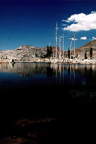
Lake Aloha is a large shallow backcountry reservoir located at an elevation of 8,116 feet in the Sierra Nevada Range, west of Lake Tahoe in El Dorado County, in eastern California.
Wisconsin's 3rd congressional district covers most of the Driftless Area in southwestern and western Wisconsin. The district includes the cities of Eau Claire, La Crosse, and Stevens Point, as well as many Wisconsin-based exurbs of the Minneapolis-St. Paul metropolitan area. It borders the states of Minnesota, Iowa, and Illinois. Republican Derrick Van Orden has represented the district since 2023.

The United States Census Bureau defines the Rochester, Minnesota Metropolitan Statistical Area (MSA) as an area consisting of five counties in southeast Minnesota, anchored by the city of Rochester. As of 2018, the US Census Bureau estimates that the Rochester metropolitan statistical area has a population of 221,587. The Rochester–Austin combined statistical area has a population of 259,813 as of 2018.

The Salt Lake City metropolitan area is the metropolitan area centered on the city of Salt Lake City, Utah. The Office of Management and Budget and the United States Census Bureau currently define the Salt Lake City, Utah Metropolitan Statistical Area as comprising two counties: Salt Lake and Tooele. As of the 2020 census, the MSA had a population of 1,257,936. The Salt Lake City Metropolitan Area and the Ogden-Clearfield Metropolitan Area were a single metropolitan area known as the Salt Lake City-Ogden Metropolitan Area until being separated in 2005.

Deep Creek Township is a township in Clinton County, Iowa, United States. As of the 2000 census, its population was 713.
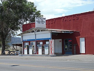
Valley Falls is a small unincorporated community in Lake County, Oregon, United States. The settled area is located at the junction of U.S. Route 395 and Oregon Route 31. The community is named for a small falls on the Chewaucan River just north of the occupied site. East of Valley Falls, the cliff face of Abert Rim overlooks the community.
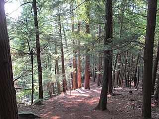
Jacobs Hill is a 173-acre (70 ha) open space preserve in Royalston, Massachusetts acquired in 1975 by the land conservation non-profit organization The Trustees of Reservations. The preserve includes scenic vistas, ledges, woodlands, a northern bog, and Spirit Falls, a 30 foot (9.1 m) waterfall. The 22-mile (35 km) Tully Trail passes through the property. Views from the ledges include the Berkshires as well as nearby Long Pond and the Tully River Valley, Tully Mountain, and Mount Grace.
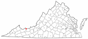
Falls Mills is an unincorporated community and census-designated place along Virginia State Route 102 in Tazewell County, Virginia, United States and is located at the mouth of the valley of Mud Fork creek. It is part of the Bluefield, WV-VA micropolitan area, which has a population of 107,578.

Wanakah is a hamlet in the town of Hamburg in Erie County, New York, United States. As of the 2010 census, it had a population of 3,199.

Falls Creek, also known as the Falls River, is a tributary of the Tuolumne River in Yosemite National Park, California, United States. The creek begins at the northern boundary of the national park and flows 24 miles (39 km) to empty into the Tuolumne at Hetch Hetchy Reservoir, dropping over two well-known waterfalls. The Pacific Crest Trail and other national park trails follow the creek for much of its course.

Edna Lake is an alpine lake in Boise County, Idaho, United States, located high in the Sawtooth Mountains in the Sawtooth National Recreation Area. The lake is approximately 17 miles (27 km) southwest of Stanley and 14.5 miles (23.3 km) southeast of Grandjean. Located in the remote central Sawtooth Wilderness, Edna Lake can be reached by trails from many directions, including the Sawtooth Valley (east), Grandjean (northwest), Redfish Lake (north), and Atlanta (south).
Vernon Lake is an alpine lake in Boise County, Idaho, United States, located high in the Sawtooth Mountains in the Sawtooth National Recreation Area. The lake is approximately 17 miles (27 km) southwest of Stanley and 14.5 miles (23.3 km) southeast of Grandjean. Located in the remote central Sawtooth Wilderness, Vernon Lake can be reached by trails from many directions, including the Sawtooth Valley (east), Grandjean (northwest), Redfish Lake (north), and Atlanta (south).

Virginia Lake is an alpine lake in Boise County, Idaho, United States, located high in the Sawtooth Mountains in the Sawtooth National Recreation Area. The lake is approximately 17 miles (27 km) southwest of Stanley and 14.5 miles (23.3 km) southeast of Grandjean. Located in the remote central Sawtooth Wilderness, Edna Lake can be reached by trails from many directions, including the Sawtooth Valley (east), Grandjean (northwest), Redfish Lake (north), and Atlanta (south).

The Spokane–Spokane Valley Metropolitan Statistical Area, as defined by the United States Census Bureau, is an area consisting of Spokane and Stevens counties in Washington state, anchored by the city of Spokane and its largest suburb, Spokane Valley. As of July 1, 2021, the MSA had an estimated population of 593,466. The Spokane Metropolitan Area and the neighboring Coeur d'Alene metropolitan area, make up the larger Spokane–Coeur d'Alene combined statistical area. The urban areas of the two MSAs largely follow the path of Interstate 90 between Spokane and Coeur d'Alene. In 2010, the Spokane–Spokane Valley MSA had a gross metropolitan product of $20.413 billion.

Lake Circle was a glacial lake that formed during the late Pleistocene epoch along the Redwater River in eastern Montana. After the Laurentide Ice Sheet retreated, glacial ice melt accumulated in the basin surrounded by the ridges of the preglacial valley and the retreating glacier. Southwest of Nickwall are the remnants of a broad abandoned valley with long side slopes. The valley runs north from Redwater Creek to the Missouri River. The bottom is poorly drained and about 1 mile (1.6 km) in width. It lies 2,015 to 2,020 feet above the sea level and 40 to 50 feet above the Missouri River bottomland. The upland slopes are extensive, clear and flat. The valleys surrounding it are dissected with V-shaped coulees. The difference between the Redwater valley and those around it reflect stream erosion vs. lake sedimentation. The drift in the valleys, appears to be as left by the glacier in the previously created valleys. Using the dating of lake deposits near Great Falls, Montana, the Havre lobe of the Laurentide Ice Sheet dammed the ancestral Missouri River during the late Wisconsin Glacial Period.


