Lake Waitamoumou

Last updated

Lake Waitamoumou
Lake Waitamoumou from south Oct 2012.JPG
Lake Waitamoumou (October 2012)
New Zealand relief map.jpg
Disc Plain red.svg
Lake Waitamoumou
Lake Waitamoumou is in the Waikato region of the North Island.
Location Waikato District, Waikato region, North Island
Coordinates 37°47′21″S174°50′34″E / 37.78917°S 174.84278°E / -37.78917; 174.84278 Coordinates: 37°47′21″S174°50′34″E / 37.78917°S 174.84278°E / -37.78917; 174.84278
Type Endorheic lake
Primary inflows stream from Horea
Primary outflows seepage
Catchment area 1 km2 (0.39 sq mi)
Basin  countries New Zealand
Surface area2.38 ha (5.9 acres)
Surface elevation24 m (79 ft)

Lake Waitamoumou is a small dune-dammed lake a kilometre north of Raglan in the Waikato region of New Zealand.

Contents

Geology

That the dunes have formed in just 800 years is credible when comparing these photos of a newly dune-dammed lake about 600m north of Waitamoumou. Left June 2007. Centre May 2012. Right Dec. 2017. The pampas on the right bank is in the same place in all photos, but the lake has grown as the sand has further blocked its valley and extra sand has covered some of the cabbage trees. Sand dune lake Te Horea 2007-2017.jpg
That the dunes have formed in just 800 years is credible when comparing these photos of a newly dune-dammed lake about 600m north of Waitamoumou. Left June 2007. Centre May 2012. Right Dec. 2017. The pampas on the right bank is in the same place in all photos, but the lake has grown as the sand has further blocked its valley and extra sand has covered some of the cabbage trees.

Brown clay underlies the dunes, [1] which limits the rate of seepage through the dunes, thus forming lakes where dune advance has blocked valleys. The lake bed and stream are on Awhitu sands. They are about a million years old and made up of pumiceous cross bedded brown and yellow clayey sands. The lake is dammed by dunes of Nukumiti Sands which have formed in the last 800 years. [2]

Biota

It seems no detailed survey has been done of the lake. As cattle often walk in the lake, it is likely to be polluted. In the 1970s the dunes between the lake and the harbour were sown with tree lupin (Lupinus arboreus) and Marram Grass, which has reduced sand movement and provided a low quality pasture. Frogs can be heard croaking in the lake. The pompilid wasp (Cryptocheilus australis) and its prey, the nursery web spider (Dolomedes minor), have been seen near the lake.

History

A flake of tuhua (obsidian), used for sharp tools, near the lake Obsidian near Te Kaha Point.jpg
A flake of tūhua (obsidian), used for sharp tools, near the lake

Remains of stone tools and other artefacts show that this area was heavily populated in pre-Colonial times. Raglan Museum has a collection of these Ngāti Taahinga artefacts, [3] with an exhibition of some 2,000 items opened in 2015. Some of the stones are thought to have come from D'Urville Island, Mayor Island / Tuhua and Whakaari/White Island, [4] confirming significant trading in pre-colonial times. [5] The archaeology map [6] records some 30 sites nearby.

The county history [7] says, "On the 25th of May 1850, the chief of the Ngāti Mahuta hapu concerned, ceded to the Crown, the land known as Te Horea. . . In 1874 the whole of Te Akau, with the exception of certain native reserves, was leased to John Studholme, of Canterbury, for a term of 30 years. Soon the smoke from extensive fires marked further Pakeha inroads into the native forests of the island." His 90,000 acre lease lasted until the early 1890s, when the New Zealand Loan and Mercantile Agency Company took it on. It was known as Darrow's Station when he was manager, but the Liberal land reforms [8] resulted in the break up of Te Akau Station in 1911, after which much more of the native forest was felled and burnt. [9]

See also

Related Research Articles

Raglan, New Zealand Minor urban area in Waikato, New Zealand

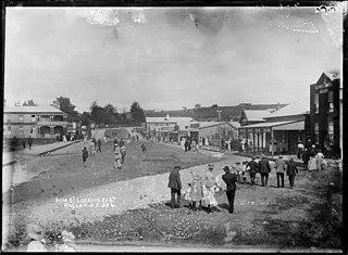
Raglan is a small beachside town located 48 km west of Hamilton, New Zealand on State Highway 23. It is known for its surfing, and volcanic black sand beaches.

Tuakau Place in Waikato region, New Zealand

Tuakau is a town in the Waikato region, formerly part of the Auckland Region until 2010, when it became part of Waikato District in the North Island of New Zealand. The town serves to support local farming, and is the residence of many employees of New Zealand Steel at Glenbrook.

Waikato District Territorial authority in Waikato, New Zealand

Waikato District is a territorial authority of New Zealand, in the northern part of Waikato region, North Island. Waikato District is administered by the Waikato District Council, with headquarters in Ngāruawāhia.

Aotea Harbour Place in New Zealand

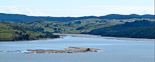
Aotea Harbour is a settlement and smallest of three large natural inlets in the Tasman Sea coast of the Waikato region of New Zealand's North Island. It is located between Raglan Harbour to the north and Kawhia Harbour to the south, 30 kilometres southwest of Hamilton.

Kawhia Harbour Place in Waikato region, New Zealand

Kawhia Harbour is one of three large natural inlets in the Tasman Sea coast of the Waikato region of New Zealand's North Island. It is located to the south of Raglan Harbour, Ruapuke and Aotea Harbour, 40 kilometres southwest of Hamilton. Kawhia is part of the Ōtorohanga District Council and is in the King Country. It has a high-tide area of 68 km2 (26 sq mi) and a low-tide area of 18 km2 (6.9 sq mi).

Ruapuke Place in Waikato, New Zealand

Ruapuke is a small farming community in the Waikato region on the slopes of Karioi, between Raglan and Kawhia in New Zealand.

Ngāti Koata Māori iwi (tribe) in Aotearoa New Zealand

Ngāti Koata or Ngāti Kōata is a Māori iwi of New Zealand, originating on the west coast of Waikato, but now mainly at the northern tip of South Island.

Oparau River

The Ōpārau River is a river of the Waikato Region of New Zealand's North Island in the area occupied by Ngāti Hikairo. It flows southwest from its sources in the Pirongia Forest Park, the highest being The Cone, and flows into the Kāwhia Harbour, 5 kilometres (3 mi) east of Kāwhia. The river has about 171 km (106 mi) of tributaries.

Tawatahi River

The Tawatahi River is a short river of the Waikato Region of New Zealand's North Island. It flows into the northern shore of Raglan Harbour.

Whatawhata Township in Waikato region, New Zealand

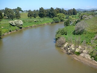
Whatawhata, previously also spelt Whata Whata, is a small town in the Waikato region on the east bank of the Waipa River, at the junction of State Highways 23 and 39, 12 km (7.5 mi) from Hamilton. Te Araroa tramping route passes through Whatawhata.

Rangiriri Place in Waikato, New Zealand

Rangiriri is a rural community in the Waikato District and Waikato region of New Zealand's North Island. It is located on the Waikato River near Lake Waikare in the Waikato District. State Highway 1 now bypasses Rangiriri.

Te Mata, Waikato District Village in Waikato region, New Zealand

Te Mata is a small settlement 47 km (29 mi) from Hamilton and 15 km (9.3 mi) from Raglan.

Te Uku Village in Waikato region, New Zealand

Te Uku is a small, mainly farming, settlement on SH23 in the North Island of New Zealand, located 34 km (21 mi) from Hamilton and 11 km (6.8 mi) from Raglan. It has a 4-Square shop, church, coffee stall and art gallery, filling station, hall, school and Xtreme Zero Waste recycle bins.

Lake Whangape

Lake Whangape is shallow, supertrophic, lateral and the second largest lake in the lower Waikato River basin in New Zealand. One source said the name translated to 'a large sheet of water', another that it was a chief's name.

Te Ākau Hamlet in Waikato region, New Zealand

Te Ākau is a small farming settlement in the North Island of New Zealand, located 62 km (39 mi) north west of Hamilton, 39 km (24 mi) south west of Huntly, 45 km (28 mi) south of Port Waikato and 47 km (29 mi), or 19 km (12 mi) by ferry and road, north of Raglan. It has a hall and a school.

Glen Massey Village in Waikato region, New Zealand

Glen Massey is a former mining village, 9.5 km (5.9 mi) west of Ngāruawāhia, which was, until 1958, terminus of the Glen Massey Line. It then went into decline, but is now becoming a home for Hamilton commuters.

Lake Opuatia

Lake Opuatia is a small lake in the much larger Opuatia wetland, which drains from the west into the Waikato River. It lies near the foot of a long valley drained by the Opuatia Stream.

Whitikahu Hamlet in Waikato, New Zealand

Whitikahu is a settlement scattered along Whitikahu Rd in the Waikato District and Waikato region of New Zealand's North Island.

Hauturu is a village near the eastern shores of the Kawhia Harbour, in the Otorohanga District and Waikato region of New Zealand's North Island.

Waitetuna Village in Waikato Region, New Zealand

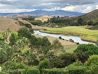
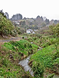
Waitetuna is a rural community in the Waikato District and Waikato region of New Zealand's North Island. It is located on the valley of the Waitetuna River, upstream from the Raglan Harbour.

References

  1. NZ Dept of Scientific & Industrial Research – Geology of Ironsand Resources of NZ, David Kear, 1979
  2. Geology of the Raglan-Kawhia Area: Institute of Geological & Nuclear Sciences (N.Z.), Barry Clayton Waterhouse, P. J. White 1994 ISBN   0-478-08837-X
  3. "Exhibitions – Raglan & District Museum". Raglanmuseum.co.nz. 18 April 2014. Retrieved 27 March 2016.
  4. Stuff.co opening of Raglan Museum exhibition
  5. Te Ara encyclopedia - Early Māori trade
  6. "NZAA Site Viewer". Nzaa.eaglegis.co.nz. Archived from the original on 26 June 2009. Retrieved 27 March 2016.
  7. Vennell, C. W.; Williams, Susan (1976). Raglan County Hills and Sea: A Centennial History 1876-1976 - C. W. Vennell, Susan Williams - Google Books. ISBN   9780868640020 . Retrieved 18 December 2012.
  8. "Liberal Land Policy for Closer Settlement, 1891–1911 – Te Ara: The Encyclopedia of New Zealand". Teara.govt.nz. 23 April 2009. Retrieved 27 March 2016.
  9. Off the Sheep's Back: Bill Richards Lindon Pub., 1986 ISBN   0864700148, 9780864700148