Lake Yuriria

Last updated
Lake Yuriria
Lago Yuriria, Guanajuato- Yuriria Lake, Guanajuato (24321532035).jpg
Mexico Guanajuato location map.svg
Red pog.svg
Lake Yuriria
Location of Lake Yuriria in Guanajuato
Mexico relief location map.jpg
Red pog.svg
Lake Yuriria
Location of Lake Yuriria in Mexico
Location Guanajuato, Mexico
Coordinates 20°14′51″N101°8′58″W / 20.24750°N 101.14944°W / 20.24750; -101.14944
Type Reservoir
Native nameLaguna de Yuriria (Spanish)
Primary inflows canal to the Lerma River
Primary outflows canal to the Lerma River
Catchment area Lerma River
Basin  countriesMexico
Surface area7,200 ha (18,000 acres)
Max. depth2.6 m (8 ft 6 in)
Surface elevation1,730 m (5,680 ft)
Settlements Yuriria
Official nameLaguna de Yuriria
Designated2 February 2004
Reference no.1934 [1]

Lake Yuriria (Spanish Laguna de Yuriria) is a reservoir in Guanajuato state of central Mexico. The reservoir has existed since the 16th century, and is used for irrigation of the surrounding farms. The lake is an important habitat for waterbirds, and was declared a wetland of international importance. [1]

Contents

Geography

Lake Yuriria is located in the basin of the Lerma River, in the southern portion of Guanajuato state. It lies west of the Lerma River, to which it is connected by a canal. The town of Yuriria is on the south shore of the lake, and the lake is within Yuriria Municipality.

The lake covers an area of 7200 ha, and is generally shallow, with a maximum depth of 2.6 m. [2]

The lake is linked by a canal to the Lerma River, which refills the lake during wet periods. Lake water is distributed to adjacent farms by irrigation channels during dry months. Flow to and from the Lerma is regulated by gates. [3]

Lake Cuitzeo lies to the north. Lake Cuitzeo is mostly a closed, or endorheic basin, but historically it overflowed into Lake Yuriria via an old channel. Lake Cuitzeo's water is brackish and unfit for irrigation, and by the 19th century a levee was built south of Lake Cuitzeo to prevent overflows into Lake Yuriria. [3]

History

The name is a shortened version Yuririapundaro, which means "lake of blood" in the Purépecha language. Prior to the Spanish conquest, the lake was part of the Purépecha Empire. [4]

The canal was constructed in 1548 at the direction of Friar Diego de Chávez, an Augustinian friar, and is among the first hydraulic engineering works in colonial America. Friar Diego de Chávez also commenced construction of the Augustinan monastery in the town of Yuriria, on the southern shore of the lake. [4] [1]

Flora and fauna

The lake is eutrophic, with low visibility (.2 meters), and abundant aquatic vegetation. [2]

The lake is an important habitat for migratory birds. 142 bird species were recorded between 1981 and 1997, of which 44 are aquatic. [5] Species include the red-tailed hawk (Buteo jamaicensis), peregrine falcon (Falco peregrinus), blue-winged teal (Spatula discors), American wigeon (Mareca americana), Mexican duck (Anas diazi), American white pelican (Pelecanus erythrorhynchos), Townsend's solitaire (Myadestes townsendi), black-vented oriole (Icterus wagleri), hooded oriole (Icterus cucullatus), and black-polled yellowthroat (Geothlypis speciosa). [1] It is designated an Important Bird Area. [5]

The land surrounding the lake is in the Bajío dry forests ecoregion. [6]

Conservation

In 2004 it was designated a wetland of international importance under the Ramsar convention. The Ramsar site covers 15,020 ha, and includes the entire lake and the lands around the shore. [1]

Related Research Articles

<span class="mw-page-title-main">Guanajuato</span> State of Mexico

Guanajuato, officially the Free and Sovereign State of Guanajuato, is one of the 32 states that make up the Federal Entities of Mexico. It is divided into 46 municipalities and its capital city is Guanajuato.

<span class="mw-page-title-main">Silao</span> City in Guanajuato, Mexico

Silao, officially Silao de la Victoria, is a city in the west-central part of the state of Guanajuato in Mexico. It is the seat of the municipality with the same name. As of the 2005 census, the city had a population of 66,485, making it the seventh-largest city in the state. Silao is a center of agricultural and industrial activity.

<span class="mw-page-title-main">Lake Pátzcuaro</span> Lake in Mexico

Lake Pátzcuaro is a lake in the municipality of Pátzcuaro, Michoacán, Mexico.

<span class="mw-page-title-main">Yuriria</span> Place in Guanajuato, Mexico

Yuriria, Guanajuato, Mexico,(Spanish: [ɟʝuˈɾiɾja]), is one of 46 municipalities in the Mexican state of Guanajuato.

<span class="mw-page-title-main">Lerma River</span> River in Mexico

The Lerma River is Mexico's second longest river. It is a 750 km-long (470 mi) river in west-central Mexico that begins in Mexican Plateau at an altitude over 3,000 metres (9,843 ft) above sea level, and ends where it empties into Lake Chapala, Mexico's largest lake, near Guadalajara, Jalisco. Lake Chapala is the starting point of Río Grande de Santiago, which some treat as a continuation of the Lerma River. In combination, the two are often called the Lerma Santiago River. The Lerma River is notorious for its pollution, but the water quality has demonstrated considerable improvement in recent years due mostly to government environmental programs and through massive upgrading projects of sanitation works.

<span class="mw-page-title-main">Lake Cuitzeo</span>

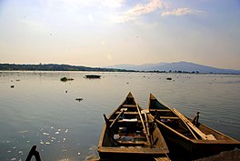
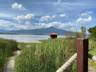
Lake Cuitzeo is a lake in the central part of Mexico, in the state of Michoacán. It has an area of 300–400 km2 (120–150 sq mi). The lake is astatic, meaning the volume and level of water in the lake fluctuates frequently. It is the second-largest freshwater lake in Mexico.

<span class="mw-page-title-main">Salvatierra, Guanajuato</span> City and municipality in Mexico

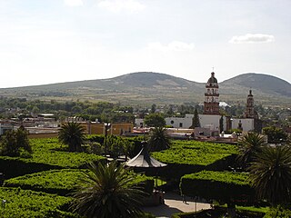
Salvatierra is a Mexican city located in the valley of Huatzindeo in the lowlands of the state of Guanajuato. It is rich in civil and religious architecture; haciendas, bridges, convents and large houses surrounded in tradition and history. With an area of 507.70 square kilometres, Salvatierra accounts for 1.66% the total area of the state. It is bordered to the north by Tarimoro and Cortazar, to the south by Acámbaro and the state of Michoacán, to the west by Yuriria and Santiago Maravatío, and to the northeast by Jaral del Progreso. The municipality had a total of 94,558 inhabitants of which 34,066 lived in the city of Salvatierra, according to the 2005 census. As of 2020 the municipality had a total of 94,126 inhabitants, compared to 2010, the population in Salvatierra decreased by -3.02%

<span class="mw-page-title-main">Uriangato</span> City in Guanajuato, Mexico

Uriangato is a city and one of 46 municipalities of Guanajuato, located just north of the border between the states of Guanajuato and Michoacán in west central Mexico. Uriangato city is geographically united with Moroleon city and Yuriria city, these three cities form a metropolitan area. Since October 2010, this metropolitan area is the 75th biggest city of Mexico and the 5th biggest in Guanajuato. It is smallest of the 56 metropolitan areas in Mexico.

<span class="mw-page-title-main">Central Mexican matorral</span> Xeric shrubland ecoregion in Mexico

The Central Mexican matorral is an ecoregion of the deserts and xeric shrublands biome of central Mexico. It is the southernmost ecoregion of the Nearctic realm.

<span class="mw-page-title-main">Bajío dry forests</span> Tropical dry broadleaf forest ecoregion in Mexico

The Bajío dry forests is a tropical dry broadleaf forest ecoregion in western−central Mexico.

<span class="mw-page-title-main">Huandacareo</span> Archaeological zone in Michoacán, Mexico

Huandacareo is an archaeological zone located about 60 kilometers north of the city of Morelia, in the state of Michoacán.

<span class="mw-page-title-main">Cuitzeo</span> Municipality in Michoacán, Mexico

Cuitzeo is a municipality located in the north of the Mexican state of Michoacán. The municipal seat is the town of Cuitzeo del Porvenir It is located in a relatively flat depression around Lake Cuitzeo, a large, very shallow lake, which is in danger of disappearing. The town was officially founded in 1550, with the founding of a large Augustinian monastery, which still stands. Today, the town is the seat of a rural municipality, providing local government to surrounding communities.

<span class="mw-page-title-main">Jose Corona Nuñez</span>

José Corona Núñez was a Mexican author, anthropologist, and history professor who discovered several important archeological sites throughout México. His main body of work revolved around his native state of Michoacán, and in particular the Tarascan or Purépecha culture.

Federal Highway 43D is a toll highway connecting the cities of Morelia, Michoacán and Salamanca, Guanajuato. It is operated by Autopista Morelia-Salamanca, S.A. de C.V. (CAMSSA), and the toll is 93 pesos to travel its 107.95-kilometre (67.08 mi) length.

<span class="mw-page-title-main">Sinaloan dry forests</span> Tropical dry broadleaf forest ecoregion in Mexico

The Sinaloan dry forests is a tropical dry broadleaf forest ecoregion in western Mexico. It is the northernmost ecoregion of the Neotropical realm.

<span class="mw-page-title-main">Central Mexican wetlands</span> Flooded grasslands ecoregion of central Mexico

The Central Mexican wetlands is a flooded grasslands and savannas ecoregion in central Mexico.

<span class="mw-page-title-main">Siete Luminarias</span>

Siete Luminarias is a group of seven extinct volcanoes in central Mexico, located in and around the town of Valle de Santiago in the state of Guanajuato.

<span class="mw-page-title-main">Sierra de Lobos</span> Mountain range in Mexico

Sierra de Lobos is a mountain range in Guanajuato state of central Mexico, The mountains rise north of León. The range is a protected natural area, and provides surface water, groundwater recharge, wildlife habitat, and recreation for the surrounding region.

<span class="mw-page-title-main">Ría Celestun Biosphere Reserve</span>

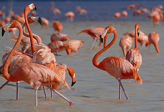
Ría Celestun Biosphere Reserve is a biosphere reserve in Mexico. It is located on the northwestern Yucatán Peninsula in the states of Yucatán and Campeche. The reserve is home to extensive mangrove wetlands, and rich in birds and other wildlife.

Los Petenes Biosphere Reserve is a biosphere reserve in Mexico. It is located on the western Yucatán Peninsula in the state of Campeche. The reserve is home to extensive mangrove wetlands, and rich in birds and other wildlife.

References

  1. 1 2 3 4 5 "Ciénegas de Lerma". Ramsar Sites Information Service. Retrieved 26 July 2022.
  2. 1 2 Sigala, Itzel, et al. “Basic Limnology of 30 Continental Waterbodies of the Transmexican Volcanic Belt across Climatic and Environmental Gradients.” Boletín de La Sociedad Geológica Mexicana, vol. 69, no. 2, 2017, pp. 313–70. JSTOR, http://www.jstor.org/stable/26461901. Accessed 26 Jul. 2022.
  3. 1 2 Murphy, Michael E. (2020) Irrigation In The Bajio Region Of Colonial Mexico. Routledge, 2020. ISBN 9780367161149
  4. 1 2 “The Yuriria and Cuitzeo Monasteries.” Artes de México, no. 86/87, 1966, pp. 18–19. JSTOR, http://www.jstor.org/stable/24312711. Accessed 25 Jul. 2022.
  5. 1 2 Important Bird Areas factsheet: Laguna de Yuriria. BirdLife International (2022). Accessed 27 July 2022.
  6. "Bajio dry forests". DOPA Explorer. Accessed 26 July 2022.