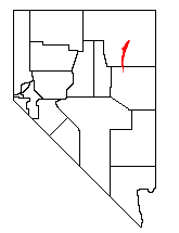
The Ruby Mountains are a mountain range, primarily located within Elko County with a small extension into White Pine County, in Nevada, United States. Most of the range is included within the Humboldt-Toiyabe National Forest. The range reaches a maximum elevation of 11,387 feet (3,471 m) on the summit of Ruby Dome. To the north is Secret Pass and the East Humboldt Range, and from there the Rubies run south-southwest for about 80 miles (130 km). To the east lies Ruby Valley, and to the west lie Huntington and Lamoille Valleys. The Ruby Mountains are the only range of an introduced bird, the Himalayan snowcock, in North America.

The Desolation Wilderness is a 63,960-acre (258.8 km2) federally protected wilderness area in the Eldorado National Forest and Lake Tahoe Basin Management Unit, in El Dorado County, California. The crest of the Sierra Nevada runs through it, just west of Lake Tahoe.

Curecanti National Recreation Area(Pronounced or .) is a National Park Service unit located on the Gunnison River in western Colorado. Established in 1965, Curecanti National Recreation Area is responsible for developing and managing recreational facilities on three reservoirs, Blue Mesa Reservoir, Morrow Point Reservoir and Crystal Reservoir, constructed on the upper Gunnison River in the 1960s by the U.S. Bureau of Reclamation to better utilize the vital waters of the Colorado River and its major tributaries. A popular destination for boating and fishing, Curecanti offers visitors two marinas, traditional and group campgrounds, hiking trails, boat launches, and boat-in campsites. The state's premiere lake trout and Kokanee salmon fisheries, Curecanti is a popular destination for boating and fishing, and is also a popular area for ice-fishing in the winter months.

The Granite Chief Wilderness is a 19,048 acre (77 km2) federally designated wilderness area of the Tahoe National Forest. Created by the California Wilderness Act of 1984, it is located in the Sierra Nevada mountains west of Lake Tahoe in the U.S. state of California. It is managed by the U.S. Forest Service Tahoe National Forest. Elevations range from 4,800 feet (1,500 m) to 9,019 feet (2,749 m) at the summit of Granite Chief.

Ostrander Lake is located in Yosemite National Park, approximately 10 miles (16 km) south of Yosemite Valley and 10 miles (16 km) east of the Badger Pass Ski Area, at an elevation of 8,500 feet (2,600 m). The lake is a popular destination for cross-country skiers during the winter. It is the primary source of Bridalveil Creek, which feeds Bridalveil Falls.

Camp Lake is a small tarn located in the Emigrant Wilderness in Tuolumne County, California, approximately 10 km (6.2 mi) north of Yosemite National Park. It is accessible only to hikers and equestrians via the popular Deer Lake Trail.

Gilmore Lake in California is a backcountry lake in the Sierra Nevada mountain range, to the west of Lake Tahoe in the Desolation Wilderness. It can be reached by hiking west out of the Glen Alpine Springs trailhead near the town of South Lake Tahoe. This lake offers great fishing for Lake trout.

The Thousand Lakes Wilderness is located within the southern portion of the Cascade Range in northeastern California. The 16,335-acre (66 km2) wilderness was established in 1964 with the passage of the Wilderness Act and is administered by Lassen National Forest. The area lies within Shasta County, midway between the town of Burney and Lassen Volcanic National Park.

The South Warner Wilderness is a federally designated wilderness area 12 miles (19 km) east of Alturas, California, United States. It encompasses more than 70,000 acres (283 km2) of the Warner Mountains. It is within the Modoc National Forest and managed by the US Forest Service. Elevations range from 5,000 feet (1,500 m) to 9,895 feet at Eagle Peak.

The Snow Mountain Wilderness is a 60,076-acre (243.12 km2) federally designated wilderness area located 65 miles (105 km) north of Santa Rosa, California, USA in the Mendocino National Forest. The U.S. Congress passed the California Wilderness Act of 1984 which created 23 new wilderness areas including Snow Mountain. It lies within the North Coast Range of mountains.

Mountain Lake Wilderness is a U.S. Wilderness Area in the George Washington and Jefferson National Forests. The wilderness area is located next to privately owned Mountain Lake, and consists of 8,314 acres (3,365 ha) in Virginia and 2,721 acres (1,101 ha) in West Virginia.

The Golden Trout Wilderness is a federally designated wilderness area in the Sierra Nevada, in Tulare County and Inyo County, California. It is located 40 miles (64 km) east of Porterville, California within Inyo National Forest and Sequoia National Forest.
The Dinkey Lakes Wilderness is a federally designated wilderness area located 45 miles (72 km) northeast of Fresno, in the state of California, United States. It comprises 30,000 acres (12,141 ha) within the Sierra National Forest and was added to the National Wilderness Preservation System by the California Wilderness Act of 1984.

The Caribou Wilderness is a federally designated wilderness area created by the Wilderness Act of 1964 and is part of the National Wilderness Preservation System. It is located 60 miles (97 km) east of Redding in the state of California, United States. The Caribou Wilderness comprises 20,546 acres (83.15 km2) and is adjacent to the east side of Lassen Volcanic National Park. Although the park is surrounded by Lassen National Forest, it is managed separately by the National Park Service, whereas the U.S. Forest Service manages the wilderness.

Bluewater Lake State Park is a state park in Prewitt, New Mexico, United States, located in the Zuni Mountains 30 miles (48 km) west of Grants. The park itself encompasses approximately 3,000 acres (12 km2), and the lake has a surface area of approximately 1,200 acres (4.9 km2).

Trout Lake, formerly known as Fish Lake and Soda Butte Lake, is a 12 acres (0.049 km2) popular backcountry lake for hikers and anglers in Yellowstone National Park. The lake is located approximately .33 miles (0.53 km) north of the Northeast Entrance Road near the confluence of Pebble Creek and Soda Butte Creek. The lake sits in a depression on a high bench above the Soda Butte Creek Canyon. A steep trail through a Douglas fir forest leads to the lake. The trailhead is located at: 44°53′57″N110°7′21″W.
The Silver Knapsack Trail is a 36.2-mile (58.3 km) trail located in the Sierra Nevada Mountains, near Johnsondale, Springville, and Three Rivers, California. It is located in Sequoia National Forest and the southernmost part of Sequoia National Park. Much of the trail lies within the Golden Trout Wilderness.
Lake Cuyamaca, also called Cuyamaca Lake, or Cuyamaca Reservoir, is a 110 acres (45 ha) reservoir and a recreation area in the eastern Cuyamaca Mountains, located in eastern San Diego County, California.
Caples lake is a reservoir that is located near Kirkwood, California along highway 88. The lake was used as a halting place for wagon travelers who were trekking the historic Mormon Emigrant trail during the Gold Rush. The lake has been used by many different groups of people including Native Americans, 49ers, and resort owners so it is known by a few different names. The variant names are clear lake, summit lake, and twin lakes. Currently, Caples lake is a reservoir being used for water and recreation. Woods creek and Emigrant creek both flow into Caples lake which drains into Caples creek. Caples creek meets up with the South Fork of the American River. Caples lake is owned by the El Dorado Irrigation District (EID) who is using it as part of the hydroelectric project 184 system.

Silver Lake is a reservoir in the Sierra Nevada mountains of California.


