
Karst is a topography formed from the dissolution of soluble rocks such as limestone, dolomite, and gypsum. It is characterized by underground drainage systems with sinkholes and caves. It has also been documented for more weathering-resistant rocks, such as quartzite, given the right conditions. Subterranean drainage may limit surface water, with few to no rivers or lakes. However, in regions where the dissolved bedrock is covered or confined by one or more superimposed non-soluble rock strata, distinctive karst features may occur only at subsurface levels and can be totally missing above ground.

A trullo is a traditional Apulian dry stone hut with a conical roof. Their style of construction is specific to the Itria Valley, in the Murge area of the Italian region of Apulia. Trulli were generally constructed as temporary field shelters and storehouses or as permanent dwellings by small proprietors or agricultural labourers. In the town of Alberobello, in the province of Bari, whole districts contain dense concentrations of trulli. The golden age of trulli was the nineteenth century, especially its final decades, which were marked by the development of wine growing.
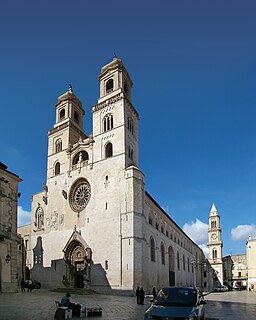
Altamura is a town and comune of Apulia, in southern Italy. It is located on one of the hills of the Murge plateau in the Metropolitan City of Bari, 45 kilometres southwest of Bari, close to the border with Basilicata. As of 2017, its population amounts to 70,595 inhabitants.

Groundwater recharge or deep drainage or deep percolation is a hydrologic process, where water moves downward from surface water to groundwater. Recharge is the primary method through which water enters an aquifer. This process usually occurs in the vadose zone below plant roots and, is often expressed as a flux to the water table surface. Groundwater recharge also encompasses water moving away from the water table farther into the saturated zone. Recharge occurs both naturally and through anthropogenic processes, where rainwater and or reclaimed water is routed to the subsurface.

Ruvo di Puglia is a city and comune (municipality) in the Metropolitan City of Bari in Apulia, southern Italy. It is a very historic city and considered a City of Art in the Apulia region. It is part of the Murge karst landscape and It is devoted to agriculture, wine and olive growing.
Santeramo in Colle is a town in the Metropolitan City of Bari and region of Apulia, southern Italy.
The Parco Nazionale dell'Alta Murgia is a national park in Apulia, southern Italy, established in 2004. It lies in the Murgia geographical area, with its headquarters in the town of Gravina in Puglia, and has an area of 677.39 square kilometres. It is part of a larger Special Protection Area established to protect the grass steppe, lesser kestrel's habitat.

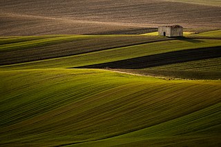
The Altopiano delle Murge is a karst topographic plateau of rectangular shape in southern Italy. Most of it lies within Apulia and corresponds with the sub-region known as Murgia or Le Murge. The plateau lies mainly in the Metropolitan City of Bari and the province of Barletta-Andria-Trani, but extends into the provinces of Brindisi and Taranto to the south; and into Matera in Basilicata to the west. The name is believed to originate from the Latin murex, meaning "sharp stone".

The Eramosa Karst is a provincially significant Earth Science Area of Natural and Scientific Interest in Ontario, Canada, located in Stoney Creek, a constituent community of the City of Hamilton, and immediately south of the Niagara Escarpment.
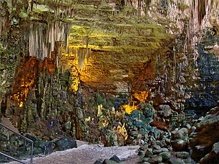
The Castellana Caves are a karst cave system located in the municipality of Castellana Grotte, in the Metropolitan City of Bari, Apulia, southern Italy.

Škocjan Caves is a cave system in Slovenia. Due to its exceptional significance, Škocjan Caves was entered on UNESCO’s list of natural and cultural World Heritage Sites in 1986. International scientific circles have thus acknowledged the importance of the caves as one of the natural treasures of planet Earth. Ranking among the most important caves in the world, Škocjan Caves represents the most significant underground phenomena both on the Karst Plateau and in Slovenia. Following independence from Yugoslavia in 1991, Slovenia committed itself to actively protecting the Škocjan Caves area and established Škocjan Caves Regional Park and its managing authority, the Škocjan Caves Park Public Service Agency.

The Metropolitan City of Bari is a metropolitan city in the Apulia region of Italy. Its capital is the city of Bari. It replaced the Province of Bari and includes the city of Bari and some forty other municipalities (comuni). It was first created by the reform of local authorities and then established by the Law 56/2014. It has been operative since January 1, 2015.
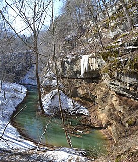
Cedar Sink is a vertical-walled large depression, or sinkhole, in the ground, that is located in Edmonson County, Kentucky and contained within and managed by Mammoth Cave National Park. The sinkhole measures 300 feet (91.4 m) from the top sandstone plateau to the bottom of the sink and was caused by collapse of the surface soil. The landscape is karst topography, which means the region is influenced by the dissolution of soluble rocks. Sinkholes, caves, and dolines typically characterize these underground drainage systems. Cedar Sink has a bottom area of about 7 acres (2.8 ha) and has more fertile soil compared to the ridgetops.

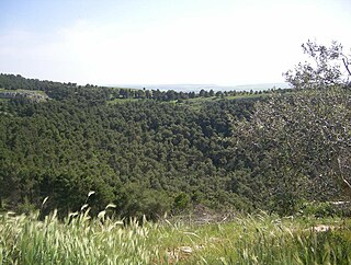
Pulo di Altamura is a doline located on the Murge plateau. It is the largest doline in that region and it is located about 6 kilometers (3.7 mi) north-west of the city of Altamura. It shares the local toponym pulo with other large dolines of the region, i.e. Pulicchio di Gravina, Pulo di Molfetta and Pulicchio di Toritto.
Pulicchio di Gravina is the second-largest doline in the Murge plateau after Pulo di Altamura. It falls into the territory of Gravina in Puglia, being located about 10 kilometers (6.2 mi) north of the latter, close to the border with Altamura's territory. It shares the local toponym pulo with other large dolines of the region, i.e. Pulo di Altamura, Pulo di Molfetta and Pulicchio di Toritto.

Gurio Lamanna is a doline shaped like a coat of arms located in the Murge plateau and falling into Gravina in Puglia's territory, on the border with Altamura, Apulia, southern Italy. It is "one of the largest karst landforms of the Murge plateau" and it is located very close to other two dolines, namely Pulicchio di Gravina and Tre Paduli. Depending on the type of geomorphologic classification employed and the author who suggested it, the karst landform can be defined either a doline or a "karst basin". It is traditionally called "karst basin", following the suggestion of Carmelo Colamonico, who first studied the doline and saw in its large size and shallow depth a good reason to distinguish it from a normal doline. The definition of "karst basin", used by Carmelo Colamonico, has been introduced by Renato Biasutti. Carmelo Colamonico stated that Gurio Lamanna is "one of the best examples of karst basin in the Murge plateau".
Vito Carmelo Colamonico was an Italian geographer, geologist and scholar. His works include studies on some karst dolines and landforms of Italy, such as Pulo di Altamura, Pulicchio di Gravina and Gurio Lamanna.
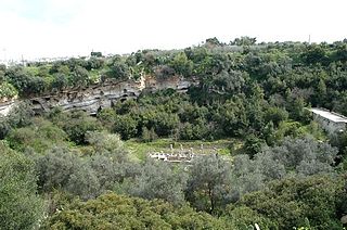
Pulo di Molfetta is a doline located on the Murge plateau, in Apulia, southern Italy, around 1.5 kilometers (0.93 mi) south-west of the city of Molfetta. It originated due to the collapse of the ceiling of one or more caves. It shares the local toponym pulo with other large dolines of the region, i.e. Pulicchio di Gravina, Pulo di Molfetta and Pulicchio di Toritto.

A fissure is a long, narrow crack opening along the surface of the Earth. It is derived from the Latin word fissura, which means 'cleft' or 'crack'. Fissures emerge in the Earth's crust, on ice sheets and glaciers, and on volcanoes.
