Lampton Avenue | |
|---|---|
| General information | |
| Type | Road |
| Length | 2 km (1.2 mi) |
| Major junctions | |
| East end | Goodwood, Tasmania |
| Brooker Highway, Main Road | |
| West end | Derwent Park, Tasmania |
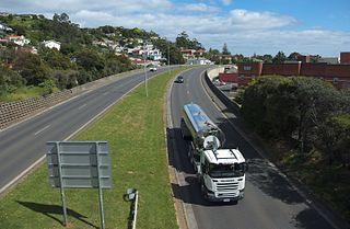
Lampton Avenue is a major link road that connects Main Road to Brooker Highway, in the northern suburbs of Hobart, Tasmania. The road starts at Main Road and continues through the traffic lights intersection on the Brooker Highway to Gepp Parade, Goodwood, Tasmania. Between Main and Brooker the road is generally a lot more busy as it picks up traffic weaving between the two major roads in a mainly industrial area. The road serves approximately 15,000 vehicles per day. [1]

Highways in Australia are generally high capacity roads managed by state and territory government agencies, though Australia's federal government contributes funding for important links between capital cities and major regional centres. Prior to European settlement, the earliest needs for trade and travel were met by narrow bush tracks, used by tribes of Indigenous Australians. The formal construction of roads began in 1788, after the founding of the colony of New South Wales, and a network of three major roads across the colony emerged by the 1820s. Similar road networks were established in the other colonies of Australia. Road construction programs in the early 19th century were generally underfunded, as they were dependent on government budgets, loans, and tolls; while there was a huge increase in road usage, due to the Australian gold rushes. Local government authorities, often known as Road Boards, were therefore established to be primarily responsible for funding and undertaking road construction and maintenance. The early 1900s saw both the increasingly widespread use of motorised transportation, and the creation of state road authorities in each state, between 1913 and 1926. These authorities managed each state's road network, with the main arterial roads controlled and maintained by the state, and other roads remaining the responsibility of local governments. The federal government became involved in road funding in the 1920s, distributing funding to the states. The depression of the 1930s slowed the funding and development of the major road network until the onset on World War II. Supply roads leading to the north of the country were considered vital, resulting in the construction of Barkly, Stuart, and Eyre Highways.

Australia's Highway 1 is a network of highways that circumnavigate the country, joining all mainland state capitals and Darwin. At a total length of approximately 14,500 km (9,000 mi) it is the longest national highway in the world, surpassing the Trans-Siberian Highway and the Trans-Canada Highway. Over a million people traverse some part of the highway network every day.

Glenorchy is a suburb of Hobart, in the state of Tasmania, Australia. Glenorchy is bound by the River Derwent to the east, Mount Wellington to the west, Hobart City to the south and Brighton to the north. The city officially begins at Creek Road New Town, in Hobart's northern suburbs, and includes, Moonah, Derwent Park, Lutana, Goodwood, Montrose, Rosetta, Berriedale, Chigwell, Claremont and Austins Ferry. It is the seat of the local government area of the same name, the City of Glenorchy.

The Midland Highway is one of Tasmania's major inter-city highways, running for 176 kilometres (109 mi) between Hobart and Launceston. It is part of the AusLink National Network and is a vital link for road freight to transport goods to and from the two cities. It represents a major north–south transportation corridor in Tasmania and has the route 1 designation as part of the National Highway. The highway consists of various traffic lane arrangements, the most common being two lanes – one in each direction, with overtaking options and at-grade intersections. At both the Launceston and Hobart sections of the highway there are small portions of grade-separated dual carriageway.
The Bass Highway is a highway in Tasmania, Australia. It connects the three cities across the north of the state – Burnie, Devonport and Launceston. The road was named due to its proximity to the Bass Strait. It is a part of the National Highway, designated as National Highway 1, together with the Midland and Brooker highways in Tasmania.

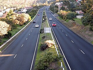
The Brooker Highway is a highway in the State of Tasmania, Australia. As one of Hobart's 3 major radials, the highway connects traffic from the Hobart city centre with the northern suburbs and is the major road connection to the cities and towns of Northern Tasmania. With an AADT of 48,000, the highway is one of the busiest in Tasmania. The Brooker Highway has recently been declared part of the National Highway.

The Tasman Highway is a highway in Tasmania, Australia. Like the Midland Highway, it connects the major cities of Hobart and Launceston – however it takes a different route, via the north-eastern and eastern coasts of the state. The Highway also acts as a major commuter road to Hobart residents living on the eastern side of the Derwent River. The designation "Tasman Highway" arises from its location facing the Tasman Sea – named, like the state itself, after Abel Tasman. The highway is one of the longest in Tasmania - 410 km (250 mi), with an average traveling time of 41⁄2 hours.

Davey Street a major one way street passing through the outskirts of the Hobart Central business district in Tasmania, Australia. Davey street is named after Thomas Davey, the first Governor of Van Diemen's Land. The street forms a one-way couplet with nearby Macquarie Street connecting traffic from the Southern Outlet in the south with traffic from the Tasman Highway to the east and the Brooker Highway to the north of the city. With annual average daily traffic of 37,200, the road is one of the busier streets in Hobart.

The Bridgewater Bridge is a road and rail bridge that carries the Midland Highway and South Railway Line across the Derwent River in Hobart, Tasmania, Australia. The steel truss vertical lift bridge and specially-built causeway connect the Hobart suburbs of Bridgewater and Granton. The bridge was completed in 1946 and accommodates a two-lane highway, a single track railway and a grade-separated footpath.
Macquarie Street a major one way street passing through the outskirts of the Hobart Central business district in Tasmania, Australia. Macquarie street is named after Lachlan Macquarie, who oversaw the planning of Hobart’s inner city grid layout. The street forms a One-way couplet with nearby Davey Street connecting traffic from the Southern Outlet in the south with traffic from the Tasman Highway to the east and the Brooker Highway to the north of the city. With annual average daily traffic of 28,500, the road is one of the busier streets in Hobart.
Main Road is a major arterial road that runs through the northern suburbs of Hobart, Tasmania. The road continues on from New Town Road at Lenah Valley and runs in close proximity with the Southern Railway Line and travels on a near parallel trajectory with the Derwent River until it reaches Granton where it merges with the Brooker Highway. Prior to the construction of the Brooker Highway the only way traffic could travel to the northern cities of the state was to drive via Main Road.
The South Arm Highway is a highway serving the southern suburbs of Hobart, on the eastern shore of the River Derwent in Tasmania, Australia. The highway is a major trunk road that carries heavy commuter traffic south from the Eastern Outlet to Howrah and Rokeby. As one of the Tasman Highway's principle Feeders and one of the eastern shore's major transport corridors, The South Arm Highway facilitates the movement of traffic between the suburbs and satellite communities to the south with the city centre and ultimately, other major cross city highways. With annual average daily traffic (AADT) of 17,000, the highway is considered a major traffic corridor within Hobart. The designation "South Arm Highway" arises from its journey south to South Arm.
The Domain Highway is a highway in Tasmania, Australia. The highway acts as a link road connecting traffic between Hobart's two busiest highways; The Tasman Highway and the Brooker Highway while also bypassing the Hobart city centre. With recorded annual average daily traffic of 25,000, the single carriageway road is busier than some of Hobart's dual carriageway highways. Commencing at the Brooker Highway at Cornelian Bay and heading southeast between the banks of the Derwent River and the Domain and Botanical Gardens. The highway ends at the Tasman Highway, on the western approach of the Tasman Bridge.

Goodwood Road is a 4-lane link road that connects the City of Glenorchy to the City of Clarence in the greater area of Hobart, Tasmania. Using the Bowen Bridge the road travels over the River Derwent in semi-highway road layout. The Road starts 10 km north of the Hobart CBD near the Hobart Showground on the Brooker Highway at Glenorchy, from there it travels east past the Elwick Racecourse, over the Bowen Bridge and connects to the East Derwent Highway at Otago. While the route the road takes is used far less than other major arterial roads in Hobart, commuters often depend on the road when major incidents occur on other major roads throughout Hobart.
Derwent Park Road is a major link road that connects the Brooker Highway to the Main Road, in the northern suburbs of Hobart, Tasmania. The Road starts at Main Road, Derwent Park and continues East across the Brooker Highway, ending at the Hobart Zinc Works. The road serves in excess of 14,000 vehicles per day.
Elwick Road is a major arterial road that runs through the northern suburbs of Hobart, Tasmania. The Road is the major link road between the Main Road and the Brooker Highway that connects to Glenorchy. The Road Passes through residential areas.
The city of Hobart, Tasmania is served by a wide variety of transport. While the city's main form of transport is private transport on the road network, transport is also available by bus, ferry and aircraft. A suburban train service operated between Hobart and Brighton from the 1870s until 31 December 1974. There has been, however, talk in recent years of reinstating a train service in the northern suburbs.

The Hobart Area Transportation Study was a comprehensive transport plan released in 1965 for the purpose of examining the transport needs of the Australian Hobart metropolitan area over the proceeding 20 years. The study predicted the majority of the proposed traffic corridors would need to be operational by the 1985 target year.
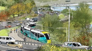
Riverline, also known as the Northern Suburbs Railway, is a proposed AU$100 million light rail system that would traverse the southernmost section of the South Railway Line, through the northern suburbs of Hobart, Tasmania.
| Hobart CBD |
| |||||||
|---|---|---|---|---|---|---|---|---|
| Greater Hobart | ||||||||