The history of Tasmania begins at the end of the Last Glacial Period when it is believed that the island was joined to the Australian mainland. Little is known of the human history of the island until the British colonisation of Tasmania in the 19th century.

Bourke Street is one of the main streets in the Melbourne central business district and a core feature of the Hoddle Grid. It was traditionally the entertainment hub of inner-city Melbourne, and is now also a popular tourist destination and tram thoroughfare.

The Brooker Highway is a highway in the Australian state of Tasmania. As one of Hobart's three major radials, the highway connects traffic from the city centre with the northern suburbs and is the major road connection to the cities and towns of northern Tasmania. With an annual average daily traffic of 48,000, the highway is one of the busiest in Tasmania. The Brooker Highway has recently been declared part of the National Highway.

Sullivans Cove is on the River Derwent adjacent to the Hobart City Centre in Tasmania. It was the site of initial European settlement in the area, and the location of the earlier components of the Port of Hobart.

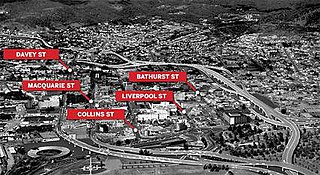
Davey Street is a major one way street passing through the outskirts of the Hobart central business district in Tasmania, Australia. Davey street is named after Thomas Davey, the first Governor of Van Diemen's Land. The street forms a one-way couplet with nearby Macquarie Street connecting traffic from the Southern Outlet in the south with traffic from the Tasman Highway to the east and the Brooker Highway to the north of the city. With annual average daily traffic of 37,200 in 2007, it is one of the busier streets in Hobart.
The following lists events that happened during 1811 in Australia.

Elizabeth Street is the major street which runs southeast to northwest through the city and suburbs of Hobart, Tasmania, Australia.

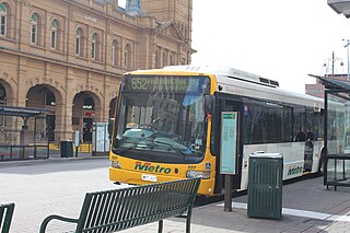
The Hobart Bus Mall is the main urban bus interchange for Metro Tasmania in the Hobart central business district. Situated on Elizabeth Street, it serves daily commuters from suburbs, nearby cities, and towns including Clarence, Glenorchy, Richmond, Cambridge and Kingborough. The interchange spans Elizabeth Street between Macquarie and Collins streets, with additional bus stops at Franklin Square and one on Liverpool Street near the Elizabeth Street Mall's north end. The interchange is within 500 metres (1,600 ft) of connecting coach services on Murray Street, ferry services and airport bus services at Brooke Street Pier.

The Hobart Rivulet, part of the River Derwent catchment, is an urban stream located in the Hobart hinterland and flows through and underneath the city, in Tasmania, Australia.

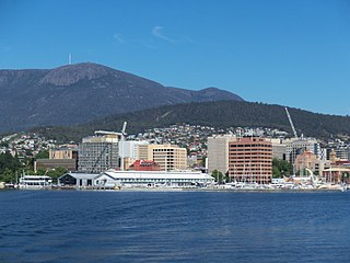
The Hobart City Centre is a suburb surrounded by metropolitan Hobart, which comprises the original settlement, the central business district, and other built-up areas. It is the oldest part of Hobart and includes many of the city's important institutions and landmarks, such as Parliament, the Supreme Court, Franklin Square, the Elizabeth Street Mall, the Royal Hobart Hospital, the Theatre Royal, Odeon Theatre, State Library, the NAB Building, the Museum, and the Cenotaph. The city centre is located in the local government areas of the City of Hobart.

Trams operated in Hobart, the capital of the Australian state of Tasmania, between 1893 and 1960. The city had an extensive and popular system that reached most of its suburbs. It was the first complete electric tram system in the Southern Hemisphere, and the only one in Australia to operate double-decker trams.

The Hotel Grand Chancellor Hobart is a twelve-storey hotel located on the waterfront of Hobart, Tasmania, Australia.

The Hobart Bypass is a proposed concept to bypass the Central Business District of Hobart, Tasmania. Currently, through traffic travels from the Tasman/Brooker Highways down the one-way Davey/Macquarie couplet to the Southern Outlet. As well as traffic concerns, there is also a call to build the bypass on the grounds that the current traffic arrangement cuts the central business district off from Hobart's waterfront.

The Hobart trolleybus system operated in Hobart, Tasmania, Australia from 1935 until 1968.

Elizabeth Street Mall is a pedestrian street mall in Hobart, Tasmania. It is located on Elizabeth Street, running for one block between Collins Street and Liverpool Street. It is the largest shopping area in the Hobart city centre. It is also a busy meeting place and busking area.

Argyle Street is a street in Hobart, Tasmania. The street was named by Lachlan Macquarie either in reference to Argyll, Scotland, where he grew up, or for the Duke of Argyll, head of Clan Campbell. Lachlan's wife had been born Elizabeth Campbell.

Murray Street is one of the four key north-west thoroughfares within the Hobart City Centre (CBD). The street runs approximately 1.7 kilometres (1.1 mi), from the junction of Arthur and Burnett Streets in North Hobart to Morrison Street near Sullivans Cove. It is named after Captain John Murray, who served as commandant of Hobart Town under the administration of Governor Lachlan Macquarie in the early 19th century.
Brisbane Street is a street in Hobart, Tasmania. The street was named for Sir Thomas Makdougall Brisbane, the sixth Governor of New South Wales.


