
Glenorchy is a suburb of Hobart, in the state of Tasmania, Australia. Glenorchy is bound by the River Derwent to the east, Mount Wellington to the west, Hobart City to the south and Brighton to the north. The city officially begins at Creek Road New Town, in Hobart's northern suburbs, and includes, Moonah, Derwent Park, Lutana, Goodwood, Montrose, Rosetta, Berriedale, Chigwell, Claremont and Austins Ferry. It is the seat of the local government area of the same name, the City of Glenorchy.

The Brooker Highway is a highway in the State of Tasmania, Australia. As one of Hobart's 3 major radials, the highway connects traffic from the Hobart city centre with the northern suburbs and is the major road connection to the cities and towns of Northern Tasmania. With an AADT of 48,000, the highway is one of the busiest in Tasmania. The Brooker Highway has recently been declared part of the National Highway.

The Tasman Highway is a highway in Tasmania, Australia. Like the Midland Highway, it connects the major cities of Hobart and Launceston – however it takes a different route, via the north-eastern and eastern coasts of the state. The Highway also acts as a major commuter road to Hobart residents living on the eastern side of the Derwent River. The designation "Tasman Highway" arises from its location facing the Tasman Sea – named, like the state itself, after Abel Tasman. The highway is one of the longest in Tasmania - 410 km (250 mi), with an average traveling time of 41⁄2 hours.

Sandy Bay is a suburb of the city of Hobart, Tasmania, Australia, located immediately south of the central business district, and adjoining the suburb of Battery Point. Sandy Bay is bounded on the east by the Derwent River, and has several beaches along the shore, the main beaches with public access are Nutgrove Beach and Long Beach.

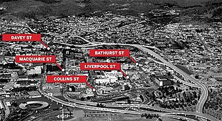
Davey Street a major one way street passing through the outskirts of the Hobart Central business district in Tasmania, Australia. Davey street is named after Thomas Davey, the first Governor of Van Diemen's Land. The street forms a one-way couplet with nearby Macquarie Street connecting traffic from the Southern Outlet in the south with traffic from the Tasman Highway to the east and the Brooker Highway to the north of the city. With annual average daily traffic of 37,200, the road is one of the busier streets in Hobart.
Macquarie Street a major one way street passing through the outskirts of the Hobart Central business district in Tasmania, Australia. Macquarie street is named after Lachlan Macquarie, who oversaw the planning of Hobart’s inner city grid layout. The street forms a One-way couplet with nearby Davey Street connecting traffic from the Southern Outlet in the south with traffic from the Tasman Highway to the east and the Brooker Highway to the north of the city. With annual average daily traffic of 28,500, the road is one of the busier streets in Hobart.
Rosetta is a residential locality in the local government area (LGA) of Glenorchy in the Hobart LGA region of Tasmania. The locality is about 3 kilometres (1.9 mi) north-west of the town of Glenorchy. The 2016 census provides a population of 2731 for the state suburb of Rosetta. It is a suburb of Hobart. The suburb is situated between the suburbs of Berriedale and Montrose and is approximately 15 minutes drive from Hobart. There is a primary school and a High school in Rosetta. The Brooker Highway runs along the eastern border of the suburb, next to the Derwent River.
Main Road is a major arterial road that runs through the northern suburbs of Hobart, Tasmania. The road continues on from New Town Road at Lenah Valley and runs in close proximity with the Southern Railway Line and travels on a near parallel trajectory with the Derwent River until it reaches Granton where it merges with the Brooker Highway. Prior to the construction of the Brooker Highway the only way traffic could travel to the northern cities of the state was to drive via Main Road.

Derwent Park is a residential locality in the local government area (LGA) of Glenorchy in the Hobart LGA region of Tasmania. The locality is about 2 kilometres (1.2 mi) east of the town of Glenorchy. The 2016 census provides a population of 657 for the state suburb of Derwent Park. It is a suburb of Hobart.

Lutana is a residential locality in the local government area (LGA) of Glenorchy in the Hobart LGA region of Tasmania. The locality is about 3 kilometres (1.9 mi) south-east of the town of Glenorchy. The 2016 census provides a population of 2353 for the state suburb of Lutana. It is a suburb of Hobart.
Dowsing Point is a residential locality in the local government area (LGA) of Glenorchy in the Hobart LGA region of Tasmania. The locality is about 2 kilometres (1.2 mi) north-east of the town of Glenorchy. The 2016 census provides a population of 85 for the state suburb of Dowsing Point.
Austins Ferry is a residential locality in the local government area (LGA) of Glenorchy in the Hobart LGA region of Tasmania. The locality is about 9 kilometres (5.6 mi) north of the town of Glenorchy. The 2016 census provides a population of 2251 for the state suburb of Austins Ferry. It is a suburb of Hobart. It is predominantly a new homes area.
The Domain Highway is a highway in Tasmania, Australia. The highway acts as a link road connecting traffic between Hobart's two busiest highways; The Tasman Highway and the Brooker Highway while also bypassing the Hobart city centre. With recorded annual average daily traffic of 25,000, the single carriageway road is busier than some of Hobart's dual carriageway highways. Commencing at the Brooker Highway at Cornelian Bay and heading southeast between the banks of the Derwent River and the Domain and Botanical Gardens. The highway ends at the Tasman Highway, on the western approach of the Tasman Bridge.

Goodwood Road is a 4-lane link road that connects the City of Glenorchy to the City of Clarence in the greater area of Hobart, Tasmania. Using the Bowen Bridge the road travels over the River Derwent in semi-highway road layout. The Road starts 10 km north of the Hobart CBD near the Hobart Showground on the Brooker Highway at Glenorchy, from there it travels east past the Elwick Racecourse, over the Bowen Bridge and connects to the East Derwent Highway at Otago. While the route the road takes is used far less than other major arterial roads in Hobart, commuters often depend on the road when major incidents occur on other major roads throughout Hobart.
Elwick Road is a major arterial road that runs through the northern suburbs of Hobart, Tasmania. The Road is the major link road between the Main Road and the Brooker Highway that connects to Glenorchy. The Road Passes through residential areas.
The Lindisfarne Interchange is a Directional T interchange which connects the Tasman Bridge to the Tasman Highway and the East Derwent Highway, on the eastern shore of the River Derwent within Hobart, Tasmania. The Interchange was constructed in 1960 in conjunction with the Tasman Bridge and opened to Traffic on 23 December 1964.
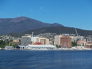
Hobart City Centre is a suburb surrounded by metropolitan Hobart, which comprises the original settlement, the central business district, and other built-up areas. It is the oldest part of Hobart and includes many of the city's important institutions and landmarks, such as Parliament, the Supreme Court, Franklin Square, the Elizabeth Street Mall, the Royal Hobart Hospital, the Theatre Royal, State Library, the NAB Building, the Museum, and the Cenotaph. The city centre is located in the local government areas of the City of Hobart.

Boyer Oval is the home headquarters of the New Norfolk District Football Club and the Molesworth Cricket Club. The ground is a former Tasmanian Football League venue, being the host venue of 825 official TFL matches for New Norfolk in TFL football from 1947 to 1999 and from 2000 it became a venue for SFL football when New Norfolk were demoted from the Statewide League. It is located on First Avenue and has a back entrance on Back River Road at New Norfolk, 38 kilometres north-west of the Hobart CBD.
The Hobart Bypass is a proposed concept to bypass the Central Business District of Hobart, Tasmania. Currently, through traffic travels from the Tasman/Brooker Highways down the one-way Davey/Macquarie couplet to the Southern Outlet. As well as traffic concerns, there is also a call to build the bypass on the grounds that the current traffic arrangement cuts the central business district off from Hobart's waterfront.
