Lancaster Mill, South Carolina

Last updated
Lancaster Mill, South Carolina
Former CDP
Nickname: 
The Red Rose City
USA South Carolina location map.svg
Red pog.svg
Lancaster Mill
Location in South Carolina
Usa edcp location map.svg
Red pog.svg
Lancaster Mill
Location in the United States
Coordinates: 34°42′36″N80°47′2″W / 34.71000°N 80.78389°W / 34.71000; -80.78389
Country United States
State South Carolina
County Lancaster
Area
  Total1.3 sq mi (3.3 km2)
  Land1.3 sq mi (3.3 km2)
  Water0.0 sq mi (0.0 km2)
Elevation
[1]
509 ft (155 m)
Population
 (2000)
  Total2,109
  Density1,660.0/sq mi (640.9/km2)
Time zone UTC-5 (Eastern (EST))
  Summer (DST) UTC-4 (EDT)
FIPS code 45-39930 [2]
GNIS feature ID1867525 [1]

Lancaster Mill is an unincorporated area and former census-designated place (CDP) in Lancaster County, South Carolina, United States. The population was 2,109 at the 2000 census. With the growth of the neighboring city of Lancaster via annexation into the Lancaster Mill area, the remaining unincorporated area was not listed as a CDP in 2010.

Contents

Geography

Lancaster Mill is located at 34°42′36″N80°47′2″W / 34.71000°N 80.78389°W / 34.71000; -80.78389 (34.709949, -80.783759). [3]

According to the United States Census Bureau, the CDP had a total area of 1.3 square miles (3.4 km2), all land.

Demographics

As of the census [2] of 2000, there were 2,109 people, 854 households, and 528 families residing in the CDP. The population density was 1,660.0 inhabitants per square mile (640.9/km2). There were 963 housing units at an average density of 758.0 per square mile (292.7/km2). The racial makeup of the CDP was 44.29% White, 53.30% African American, 0.14% Native American, 1.47% from other races, and 0.81% from two or more races. Hispanic or Latino of any race were 2.66% of the population.

There were 854 households, out of which 34.7% had children under the age of 18 living with them, 25.9% were married couples living together, 30.3% had a female householder with no husband present, and 38.1% were non-families. 32.7% of all households were made up of individuals, and 9.5% had someone living alone who was 65 years of age or older. The average household size was 2.47 and the average family size was 3.16.

In the CDP, the population was spread out, with 31.9% under the age of 18, 12.1% from 18 to 24, 26.8% from 25 to 44, 19.7% from 45 to 64, and 9.5% who were 65 years of age or older. The median age was 29 years. For every 100 females, there were 89.7 males. For every 100 females age 18 and over, there were 84.2 males.

The median income for a household in the CDP was $19,555, and the median income for a family was $20,656. Males had a median income of $22,674 versus $18,160 for females. The per capita income for the CDP was $10,896. About 31.0% of families and 32.1% of the population were below the poverty line, including 43.6% of those under age 18 and 33.3% of those age 65 or over.

Related Research Articles

<span class="mw-page-title-main">Willow Street, Pennsylvania</span> Census-designated place in Pennsylvania, United States

Willow Street is an unincorporated community and census-designated place (CDP) in Lancaster County, Pennsylvania, United States. The population was 7,578 at the 2010 census. In the early part of the 20th century, the main thoroughfare in town was lined with willow trees on both sides for the length of the town, hence the community's name. As time passed and the town grew, the road was widened and sidewalks were installed, which required the trees be removed. Only a few of the original trees remain to this day.

<span class="mw-page-title-main">Moores Mill, Alabama</span> Census-designated place in Alabama, United States

Moores Mill is an unincorporated community and census-designated place (CDP) in Madison County, Alabama, United States, and is included in the Huntsville-Decatur Combined Statistical Area. The population was 6,729 at the 2020 census, up from 5,682 at the 2010 census.

<span class="mw-page-title-main">Camp Pendleton South, California</span> Census-designated place in California, United States

Camp Pendleton South is a census-designated place (CDP) in San Diego County, California, located at the southwest corner of the Marine Corps Base Camp Pendleton. The population was 10,616 at the 2010 census, up from 8,854 at the 2000 census. Much of the population are residents of Camp Pendleton barracks situated in the area, as well as housing communities for married Marine and Navy personnel and their families. It, along with Camp Pendleton Mainside CDP, is one of two CDPs on the base.

<span class="mw-page-title-main">Ives Estates, Florida</span> Census-designated place in Florida, United States

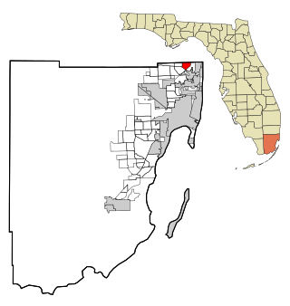
Ives Estates is a census-designated place (CDP) in Miami-Dade County, Florida. The population was 25,005 at the 2020 census, up from 19,525 in 2010.

<span class="mw-page-title-main">Princeton, Florida</span> Census-designated place in Florida, United States

Princeton is a census-designated place (CDP) and unincorporated community in Miami-Dade County, Florida, United States. The population was 39,208 at the 2020 census, up from 22,038 at the 2010 census.

<span class="mw-page-title-main">Salem, New Mexico</span> CDP in New Mexico, United States

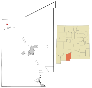
Salem is a census-designated place (CDP) in Doña Ana County, New Mexico, United States. The population was 942 at the 2010 census. It is part of the Las Cruces Metropolitan Statistical Area.

<span class="mw-page-title-main">Northbrook, Ohio</span> Census-designated place in Ohio, United States

Northbrook is a census-designated place (CDP) in Hamilton County, Ohio, United States. The population was 10,912 at the 2020 census.

<span class="mw-page-title-main">Pymatuning Central, Pennsylvania</span> Census-designated place in Pennsylvania, United States

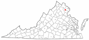
Pymatuning Central is a census-designated place (CDP) in Crawford County, Pennsylvania, United States. The population was 2,269 at the 2010 census.

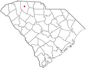
Elgin is an unincorporated community and census-designated place (CDP) in Lancaster County, South Carolina, United States. The population was 2,607 at the 2010 census.

<span class="mw-page-title-main">Irwin, South Carolina</span> Census-designated place in South Carolina, United States

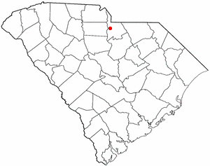
Irwin is an unincorporated community and census-designated place (CDP) in Lancaster County, South Carolina, United States. The population was 1,405 at the 2010 census.

Springdale is an unincorporated community and census-designated place (CDP) in Lancaster County, South Carolina, United States. The population was 2,574 at the 2010 census, down from 2,864 at the 2000 census.

<span class="mw-page-title-main">Woodfield, South Carolina</span> Census-designated place in South Carolina, United States

Woodfield is a census-designated place (CDP) in Richland County, South Carolina, United States. The population was 9,303 at the 2010 census. It is part of the Columbia, South Carolina Metropolitan Statistical Area.

<span class="mw-page-title-main">Saxon, South Carolina</span> CDP in South Carolina, United States

Saxon is a census-designated place (CDP) in Spartanburg County, South Carolina, United States. The population was 3,424 at the 2010 census.

Oswego is a census-designated place (CDP) in Sumter County, South Carolina, United States. The population was 95 at the 2000 census. It is included in the Sumter, South Carolina Metropolitan Statistical Area.

<span class="mw-page-title-main">Lopeño, Texas</span> CDP in Texas, United States

Lopeño is a census-designated place (CDP) in Zapata County, Texas, United States. The population was 174 at the 2010 census.

<span class="mw-page-title-main">West Gate, Prince William County, Virginia</span> Unincorporated community & Former Census-designated place in Virginia, United States

West Gate is an unincorporated community and former census-designated place (CDP) in Prince William County, Virginia, United States. The population was 7,493 at the 2000 census. It contained the now-defunct Sunnybrook Golf Club.

<span class="mw-page-title-main">Ames Lake, Washington</span> Census-designated place in Washington, United States

Ames Lake is an unincorporated community and census-designated place (CDP) in King County, Washington, United States. The population was 1,486 at the 2010 census.

<span class="mw-page-title-main">Martha Lake, Washington</span> CDP in Washington, United States

Martha Lake is a census-designated place (CDP) in Snohomish County, Washington, United States. The population was 21,129 at the 2020 census. It lies west of Mill Creek and northeast of Lynnwood, near the lake of the same name.

<span class="mw-page-title-main">Middlebury (CDP), Vermont</span> Census-designated place in Vermont, United States

Middlebury is the main settlement in the town of Middlebury in Addison County, Vermont, United States, and a census-designated place (CDP). The population was 7,304 at the 2020 census, out of a total population of 9,152 in the town of Middlebury. Most of the village is listed on the National Register of Historic Places as the Middlebury Village Historic District.

<span class="mw-page-title-main">Freeport (CDP), Maine</span> Census-designated place in Maine, United States

Freeport is a census-designated place (CDP) in the town of Freeport in Cumberland County, Maine, United States. The population was 1,485 at the 2010 census. It is part of the Portland–South Portland–Biddeford, Maine Metropolitan Statistical Area.

References

  1. 1 2 U.S. Geological Survey Geographic Names Information System: Lancaster Mill, South Carolina
  2. 1 2 "U.S. Census website". United States Census Bureau . Retrieved 2008-01-31.
  3. "US Gazetteer files: 2010, 2000, and 1990". United States Census Bureau. 2011-02-12. Retrieved 2011-04-23.