Land's End, Bandra

Last updated

Land's End
Neighbourhood
MumbaiClimate.jpg
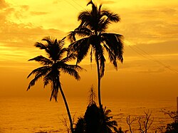
Sunset at Land's End
Country India
State Maharashtra
District Mumbai Suburban
City Mumbai
Government
  Type Municipal Corporation
  Body Brihanmumbai Municipal Corporation (MCGM)
Languages
  Official Marathi
Time zone UTC+5:30 (IST)
PIN
400050
Area code 022
Civic agency BMC
Shahrukh Khan's residence "Mannat" at Land's end Mumbai Land Ends.jpg
Shahrukh Khan's residence "Mannat" at Land's end

Lands End is the southernmost tip of Bandra in Mumbai. The area is notable for being the residence of several Bollywood actors. It is an upmarket area in Mumbai and the properties in this area is one of the most expensive properties in the world. Notable residents include Shahrukh Khan. [1] [2]

Contents

Location

Lands End is a peninsular strip of land that juts into the Arabian Sea, with a fort at its tip and a hill that comes below the fort's vista. [3]

History

In 1640, the Portuguese built a fort known as Castella de Aguada (Portuguese: Fort of the Waterpoint, also known as the Bandra Fort). It was built to serve as a watchtower overlooking Mahim Bay, the Arabian Sea and the southern island of Mahim, and as a stopping point for loading water, supplies and provisions for small ships that travelled on the Goa-Daman route.

In 1850, a Parsi businessman and philanthropist, Sir Byramjee Jeejeebhoy bought the entire area of Lands End. Byramjee spent his personal fortune to develop the area. [4] He built a road connecting Lands End with the rest of Bandra. This road is known as Byramjee Jeejeebhoy Road. He also built a promenade and sea-facing wall on the western side of Lands End. In 1865 Byramjee built his residence on top of the hill at Lands End. He lived in this house along with his son, Nanabhoy Jeejeebhoy (who founded Nana Chowk [ citation needed ]). [5]

Related Research Articles

<span class="mw-page-title-main">Bandra</span> Suburb of Mumbai, India

Bandra ([bæːɳɖɾa]) is a coastal suburb located in Mumbai, the largest city of the Konkan division in Maharashtra, India. The area is located to the immediate north of the River Mithi, which separates Bandra from the Mumbai City district. It is the third-largest commercial hub in Maharashtra, after the Bombay city district and Pune, primarily aided by the Bandra-Kurla Complex.

<span class="mw-page-title-main">Mahim</span> Neighbourhood in Mumbai City, Maharashtra, India

Mahim (Marathi: माहिम) is a neighbourhood in Mumbai, Maharashtra, India. The Mahim Junction railway station on the Western Railway and Harbour Railway of the Mumbai Suburban Railway network is the last station of the city, as neighboring Bandra comes in Mumbai Suburb. Mahim is an ethnically and religiously diverse town and has a Hindu temple, church, mosque and Parsi fire-temple existing within a few meters of each other. The town has a large Rich and Upper Middle class Marathi population.

<span class="mw-page-title-main">Juhu</span> Place in Maharashtra, India

Juhu is a suburb of Mumbai. It is known for the sprawling Juhu Beach. It is surrounded by the Arabian Sea to the west, Versova to the north, Vile Parle to the east and Santacruz to the south. Juhu is among the most expensive and affluent areas of the metropolitan area and home to many Bollywood celebrities. The nearest railway stations are Santacruz, Andheri and Vile Parle on the Western Line and Harbour Line of the Mumbai Suburban Railway. The nearest metro stations are D. N. Nagar and Andheri West. There are two minor B.E.S.T bus depots in Juhu.

<span class="mw-page-title-main">Colaba</span> Neighbourhood in Mumbai City, Maharashtra, India

Colaba is a part of the city of Mumbai, India. It is one of the four peninsulas of Mumbai while the other three are Worli, Bandra and Malabar Hill. During Portuguese rule in the 16th century, the island was known as Kolbhat. After the British took over the island in the late 17th century, it was known as Kolio.

<span class="mw-page-title-main">Salsette Island</span> Island off the coast of Maharashtra, India

Salsette Island is an island in Konkan division of the state of Maharashtra, on India's west coast. Administratively known as Greater Mumbai, the city district of Mumbai, Mumbai Suburban district, Mira Bhayander, and a portion of Thane lie within it, making it very populous and one of the most densely populated islands in the world. It has a population of more than 20 million inhabitants living on an area of about 619 square kilometres (239 sq mi).

<span class="mw-page-title-main">South Mumbai</span> Precinct of Mumbai

South Mumbai, colloquially SoBo from South Bombay in Indian English, administratively the Mumbai City District, is the city centre and the southernmost precinct of Greater Bombay. It extends from Colaba to Mahim and Sion neighbourhoods, and comprises the city's main business localities, making it the wealthiest urban precinct in India. Property prices in South Mumbai are by far the highest in India and among the highest in the world.

The Western Freeway was a proposed controlled-access highway in Mumbai, India that would stretch from Marine Drive in South Mumbai to Kandivli in the north, a distance of 29 km. The project envisioned the construction of four major sea links over the Arabian Sea along Mumbai's western coastline to reduce traffic-congestion between the Western Suburbs and South Mumbai.

<span class="mw-page-title-main">Bandra Kurla Complex</span> Business district in Mumbai, India

The Bandra Kurla Complex is a business and residential district in the city of Mumbai, India. It is a prominent upscale commercial hub which commands some of the highest property rates in the country. According to MMRDA, the complex is the first of a series of "growth centres" created to "arrest further concentration" of offices and commercial activities in eastern parts of Mumbai. It has aided to decongest the CBD in South Mumbai while seeding new areas of planned commercial real estate in the metropolitan region.

<span class="mw-page-title-main">Fort Vasai</span> Fort in Vasai, Maharashtra, India

Fort Vasai is a ruined fort of the town of Vasai (Bassein), Palghar, Maharashtra, India. The structure was formally christened as the Fort of St. Sebastian in the Indo-Portuguese era. The fort is a monument of national importance and is protected by the Archaeological Survey of India.

<span class="mw-page-title-main">Sewri Fort</span> Fort in Sewree, Mumbai

The Sewri Fort is a fort in Mumbai built by the British at Sewri. Built in 1680, fort served as a watch tower, atop a quarried hill overlooking the Mumbai harbour.

<span class="mw-page-title-main">Bandstand Promenade</span> Walkway in Maharashtra, India

The Bandstand Promenade, also known as Bandra Bandstand is a 1.2 kilometer long walkway along the sea on the western coast of Mumbai, India in the neighborhood of Bandra. It is simultaneously a popular hangout spot, a jogging track and a park.

<span class="mw-page-title-main">Castella de Aguada</span> Historic fort in India

Castella de Aguada, also known as the Bandra Fort, is a fort located in Bandra, Mumbai. "Castella" is a misspelling for Portuguese "Castelo" (castle), although it seems its Portuguese builders actually called it Forte de Bandorá. It is located at Land's End in Bandra. It was built by the Portuguese in 1640 as a watchtower overlooking Mahim Bay, the Arabian Sea and the southern island of Mahim. The strategic value of the fort was enhanced in 1661 after the Portuguese ceded the seven islands of Bombay that lay to the immediate south of Bandra to the English. The name indicates its origin as a place where fresh water was available in the form of a fountain ("Aguada") for Portuguese ships cruising the coasts in the initial period of Portuguese presence. The fort lies over several levels, from sea level to an altitude of 24 metres (79 ft). Castella de Aguada has been featured in several Hindi films, such as Dil Chahta Hai and Buddha Mil Gaya.

<span class="mw-page-title-main">Bandra–Worli Sea Link</span> Bridge connecting Bandra Basitt and Worli, Mumbai, India

The Bandra-Worli Sea Link is a 5.6 km long, 8-lane wide cable-stayed bridge that links Bandra in the Western Suburbs of Mumbai with Worli in South Mumbai. It is the longest sea bridge, as well as the 4th longest bridge in India after Bhupen Hazarika Setu, Dibang River Bridge and Mahatma Gandhi Setu. It contains pre-stressed concrete-steel viaducts on either side. It was planned as a part of the proposed Western Freeway that would link the Western Suburbs to Nariman Point in Mumbai's main business district, but is now planned to become part of the Coastal Road to Kandivali.

<span class="mw-page-title-main">Mahim Bay</span> Inlet of the Arabian Sea in Mumbai

Mahim Bay is a bay, part of the Arabian Sea in Mumbai, Maharashtra, India. The southern end is Worli, northern end is Bandra Reclamation and Mahim is in the centre. The bay was named after the islands of Mahim and Salsette were merged in the early 19th century. The Mithi River drains into Mahim Creek which drains into the Bay, and forms the border between the Mumbai city and its Suburbs.

<span class="mw-page-title-main">Mahim Causeway</span>

The Mahim Causeway is a vital link road connecting Mumbai City district/South Mumbai with its Northern and Western Suburbs. The causeway links the neighbourhoods of Mahim to the south with Bandra to the north.

Avabai, Lady Jeejeebhoy was the wife of Sir Jamsetjee Jeejeebhoy, 1st baronet. She is best known for having funded the construction of the Mahim causeway in Mumbai (Bombay), which serves today as an important link between the island city of Mumbai with its north-western suburbs.

<span class="mw-page-title-main">Byramjee Jeejeebhoy</span>

Byramjee Jeejeebhoy CSI (1822–1890) was an Indian businessman and philanthropist who founded several education institutions in Bombay. The Byramjee Jeejeebhoy College and the Byramjee Jeejeebhoy Parsee Charitable Institution in Charni Road, South Mumbai, Byramjee Jeejeebhoy Medical College in Pune and the B. J. Medical College Ahmedabad are four of the notable schools and colleges founded by him. In October 1830, the British East India Company leased Byramjee seven villages between Jogeshwari and Borivali, that totalled over 12,000 acres (49 km2). Also given to Byramjee was Land's End, Bandra, a cape with the Bandra Fort that became known as the Byramjee Jeejeebhoy Point for an annual rent of Rs. 2800. Byramjee built a beautiful, large mansion as his personal home on the hill overlooking the fort.

<span class="mw-page-title-main">History of Bombay under Portuguese rule (1534–1661)</span> Aspect of history

Bombay, also called Bom Bahia or Bom Baim in Indo-Portuguese creole, Mumbai in the local language; is the financial and commercial capital of India and one of the most populous cities in the world. It's also the cosmopolitan city centre of the Greater Bombay Metropolitan Area, and the cultural base of the Bollywood film industry. At the time of arrival of the Portuguese Armadas, Bombay was an archipelago of seven islands. Between the third century BCE and 1348, the islands came under the control of successive Hindu dynasties. The Delhi Sultanate had been ruling the area along with Chaul, New Bombay (Thana) & Damaon, with the administrative centre in Bassein (Vasai) since the raids of Malik Kafur in the Konkan region and across the Indian subcontinent. This territory in North Konkan along with the Bombay islands were later taken over by the Sultan of Guzerat from 1391 to 1534, when he had declared the end of the suzerainty of Delhi after the Timurid invasion of it. Growing apprehensive of the power of the Moghal emperor Humayun, Sultan Bahadur Shah of Gujarat was obliged to sign the Treaty of Bassein on 23 December 1534; according to which, the seven islands of Bombay, Fort San Sebastian of Bassein in strategic town of Bassein (Vasai), and its dependencies were offered to the Portuguese East Indies. The places were only later officially surrendered on 25 October 1535, by the Sultan of Guzerat.

Chemould Prescott Road, founded, is the first contemporary art gallery in Mumbai, India.

<span class="mw-page-title-main">Tandulwadi Fort</span>

Tandulwadi Fort is located near Saphale, 104 km north of Mumbai. Tandulwadi is not a fully built up fort, but a series of structures spread over the top of the mountain. The fort dates back 800 years and was primarily used as a watch tower over the surrounding plains. At a height of 1524 feet, it has views of the surrounding towns of Saphale, the Zanzorli lake, and the confluence of the Surya and Vaitarna rivers.

References

  1. "Sneak Peek: We take you inside Gauri and Shah Rukh Khan's gorgeous home 'Mannat'". www.theindusparent.com. Retrieved 12 December 2018.
  2. "Mannat Lands End, Siraj Dokadia Road". Mannat Lands End. Retrieved 8 February 2021.
  3. "Land's End - P K DAS- Mumbai Architect, Architect Activist, Urban Design and Planning,Social Architecture". P K Das. Archived from the original on 31 January 2013. Retrieved 9 September 2012.
  4. Nauzer Bharucha (7 September 2002). "Big landowners benefited from colonial largesse". The Times of India . Archived from the original on 17 June 2012. Retrieved 9 September 2012.
  5. "Full text of "Gazetteer of the Bombay Presidency"". Archive.org. Retrieved 9 September 2012.