Cadastral divisions in Victoria are called counties, which are further subdivided into parishes and townships, for cadastral or land administration purposes. Cadastral divisions of county, parish and township form the basis for formal identification of the location of any piece of land in the state. There are 37 counties and 2004 parishes and 909 townships. Parishes were subdivided into sections of various sizes for sale as farming allotments, or designated as a town and then divided into sections and these subdivided into crown allotments. However, many parishes do not follow county borders, some being located in more than one county.

The lands administrative divisions of New South Wales refers to the 141 counties within the Colony of New South Wales, that later became the Australian state of New South Wales.

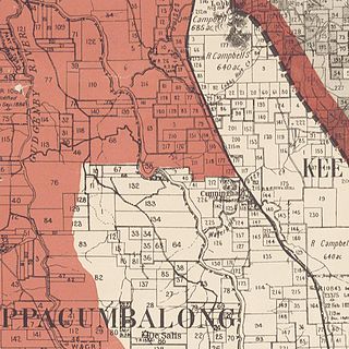
Lands administrative divisions of Australia are the cadastral divisions of Australia for the purposes of identification of land to ensure security of land ownership. Most states term these divisions as counties, parishes, hundreds, and other terms. The eastern states of Queensland, New South Wales, Victoria and Tasmania were divided into counties and parishes in the 19th century, although the Tasmanian counties were renamed land districts in the 20th century. Parts of South Australia (south-east) and Western Australia (south-west) were similarly divided into counties, and there were also five counties in a small part of the Northern Territory. However South Australia has subdivisions of hundreds instead of parishes, along with the Northern Territory, which was part of South Australia when the hundreds were proclaimed. There were also formerly hundreds in Tasmania. There have been at least 600 counties, 544 hundreds and at least 15,692 parishes in Australia, but there are none of these units for most of the sparsely inhabited central and western parts of the country.
The lands administrative divisions of Western Australia refer to subdivisions of the state of Western Australia for cadastral purposes, most of which have been in place since the 19th century. The state is divided up for this purpose into five land divisions, which in turn are subdivided into land districts, which correspond to counties in other Australian states. These districts are then subdivided further into numbered locations, as well as gazetted townsites. Together, they form part of the lands administrative divisions of Australia.
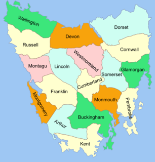
The Lands administrative divisions of Tasmania are the divisions of Tasmania into land districts and parishes for cadastral purposes, which are part of the lands administrative divisions of Australia. There are 20 land districts in Tasmania, although in the early nineteenth century there were several other systems, with 18 or 36 counties and 9 other divisions used, as well as hundreds. The land districts include the 18 former counties of the island of Tasmania which were renamed but retain the same boundaries, plus King Island and Flinders Island. The counties are referenced in the 1911 Encyclopædia Britannica, with Hobart described as being in Buckingham County, Launceston in Cornwall County and Beaconsfield in Devon County. The land districts are used for land titles today, while the Local Government Areas of Tasmania with cities and municipalities are used for political and administrative purposes.

Narrabundah Parish is a former parish of Murray County, New South Wales, a cadastral unit for use on land titles. It was formed in the nineteenth century, and existed until 1 January 1911, when the Seat of Government (Administration) Act 1910 came into force, after the land was transferred to the Commonwealth government in 1909 to be used to form the Australian Capital Territory.

Tuggeranong Parish is a parish of Murray County, New South Wales, a cadastral unit for use on land titles. It is now about a third of the size it was in the nineteenth century, after most of the land in the parish was transferred to the Australian Capital Territory in 1911. It currently includes a small section of land in New South Wales between the ACT border and Jerrabomberra Creek, but once included most of what is now the Canberra town centre of Tuggeranong.

Queanbeyan Parish is a parish of Murray County, New South Wales, a cadastral unit for use on land titles. It covers the city of Queanbeyan. It was originally bounded by the Molonglo River to the north, but is now bounded by the NSW-ACT border in the north and west. Parts of the western area of the parish were transferred to the Australian Capital Territory in 1909, including what are now the Canberra suburbs of Fyshwick, Narrabundah, Kingston, Oaks Estate, Harman and part of Hume.

The Central Division of New South Wales is one of the three divisions of New South Wales along with the Eastern and Western divisions, established under the Crown Lands Act of 1884 for the purposes of land management. In 1907, it included the Hay, Forbes and Moree land boards, as well as the western parts of the Wagga Wagga, Dubbo and Tamworth land boards. Part of its western boundary is the Lachlan River, and it includes a large part of the Riverina. Shires it included were parts of the Narrabri Shire, Goulburn Mulwaree Council, Walgett Shire, Cobar Shire and almost the entire Lachlan Shire, Bland Shire and the Bogan Shire. The Bogan Shire and the Bland Shire are the most west parts of the division.
The County of Gunbower is one of the 37 counties of Victoria which are part of the cadastral divisions of Australia, used for land titles. It is located to the south of the Murray River, from Swan Hill to Echuca.

Amungula Parish is a parish of Murray County, New South Wales, a cadastral unit for use on land titles. It is located in two non-contiguous sections, divided by the Australian Capital Territory, as most of the parish was transferred to the ACT in 1909 and now makes up much of the Kowen district. The northern section, the larger of the two, is located just to the south of Wamboin around 35°15′50″S149°17′29″E; the southern, a section of land between the Goulburn-Queanbeyan railway and the Molonglo River around 35°20′48″S149°19′49″E. Before 1909, the Molonglo River was the southern boundary of the parish. The Kings Highway passes through a small part of the southern remaining portion. It was formerly located in Yarrowlumla Shire, but is now located in Queanbeyan-Palerang Regional Council.

Majura Parish is a parish of Murray County, New South Wales, a cadastral unit for use on land titles. It is located to the east of the extreme eastern tip of the ACT. The Queanbeyan-Bungendore railway line and the Kings Highway pass through the parish. About a quarter of the original nineteenth-century parish was transferred to the ACT in 1909. The land transferred was the area between the railway line in the south and the watershed of the Molonglo River in the north. This cut off part of portion 210 of Majura Parish from the rest, giving the parish a small exclave.

Carwoola Parish is a parish of Murray County, a cadastral unit for use on land titles. It is located to the south of the Australian Capital Territory and to the south-east of Queanbeyan. The original northern and eastern boundary was the Molonglo River; this is still the boundary for most of the parish, except in the north, where the relatively small area north of the Queanbeyan-Goulburn railway line was transferred to the ACT in 1909. The south-western boundary is the Queanbeyan River. Captain's Flat Road is the major road running through the parish. The area also roughly aligns with the locality of Carwoola.
Gigerline Parish was a former parish of Murray County, New South Wales, a cadastral unit for use on land titles. It was formed in the nineteenth century and existed until 1 January 1911, when the Seat of Government (Administration) Act 1910 came into force, after the land was transferred to the Commonwealth government in 1909 to be used to form the Australian Capital Territory.
Keewong Parish is a parish of Murray County, New South Wales, a cadastral unit for use on land titles. A small part of the north-western end of the parish around 35°34′40″S149°07′28″E between the Murrumbidgee River and the Queanbeyan-Cooma railway line was transferred to the Australian Capital Territory in 1909. The southern ends of portions 177, 218, 211, 36, and 38 in the Parish of Keewong form part of the border of the ACT with New South Wales, which is mentioned in the Seat of Government Acceptance Act of 1909.
Wallaroo Parish is one of the 54 parishes of Murray County, New South Wales, a cadastral unit for use on land titles. It is bounded by the Murrumbidgee River in the west, Ginninderra Creek in the south and Gooromon Ponds in the east. The Australian Capital Territory has also formed a small part of the boundary since 1909, after a small part of land in the parish at 35°11′54″S149°00′00″E was transferred to the Commonwealth. This area is just to the west of Dunlop. The Wallaroo road is the main road in the area, which comes off the Barton Highway. The parish is similar to the locality of Wallaroo.
The Parish of Wamboin is a parish of the County of Murray, a cadastral unit for use on land titles. It is located just to the north-east of the Australian Capital Territory and includes part of the town of Bungendore on the eastern edge and the rural community of Wamboin near the south-western edge.