
Israeli settlements, or Israeli colonies, are civilian communities inhabited by Israeli citizens, overwhelmingly of Jewish ethnicity, built on lands occupied by Israel in the 1967 Six-Day War. The international community considers Israeli settlements to be illegal under international law, though Israel disputes this.

The Arab citizens of Israel are the largest ethnic minority in the country. They comprise a hybrid community of Israeli citizens with a heritage of Palestinian citizenship, mixed religions, bilingual in Arabic and Hebrew, and with varying social identities. Self-identification as Palestinian citizens of Israel has sharpened in recent years, alongside distinct identities including Negev Bedouin, the Druze people, and Arab Christians and Arab Muslims who do not identify as Palestinians. In Arabic, commonly used terms to refer to Israel's Arab population include 48-Arab and 48-Palestinian. Since the Nakba, the Palestinians that have remained within Israel's 1948 borders have been colloquially known as "48-Arabs". In Israel itself, Arab citizens are commonly referred to as Israeli-Arabs or simply as Arabs; international media often uses the term Arab-Israeli to distinguish Arab citizens of Israel from the Palestinian Arabs residing in the Palestinian territories.

Israeli-occupied territories are the lands that were captured and occupied by Israel during the Six-Day War of 1967. While the term is currently applied to the Palestinian territories and the Golan Heights, it has also been used to refer to areas that were formerly occupied by Israel, namely the Sinai Peninsula and southern Lebanon. Prior to Israel's victory in the Six-Day War, governance of the Palestinian territories was split between Egypt and Jordan, with the former having occupied the Gaza Strip and the latter having annexed the West Bank; the Sinai Peninsula and the Golan Heights were under the sovereignty of Egypt and Syria, respectively. The first conjoined usage of the terms "occupied" and "territories" with regard to Israel was in United Nations Security Council Resolution 242, which was drafted in the aftermath of the Six-Day War and called for: "the establishment of a just and lasting peace in the Middle East" to be achieved by "the application of both the following principles: ... Withdrawal of Israeli armed forces from territories occupied in the recent conflict ... Termination of all claims or states of belligerency and respect for and acknowledgment of the sovereignty, territorial integrity and political independence of every State in the area and their right to live in peace within secure and recognized boundaries free from threats or acts of force."

Majdal Shams is a Druze town in the southern foothills of Mount Hermon, north of the Golan Heights. The majority of residents are of Syrian-Druze origin. Since the June 1967 Six-Day War, the village has been held by Israel as part of its military occupation of the Golan Heights, first under martial law, but since the adoption of the 1981 Golan Heights Law under Israeli civil law, and incorporated into the Israeli system of local councils.

Ghajar is an Alawite-Arab village on the Hasbani River on the border between Lebanon and the Israeli-occupied portion of the Golan Heights, internationally considered to be part of Syria. In 2019 it had a population of 2,659.
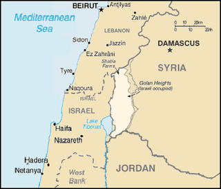
The Golan Heights, or simply the Golan, is a region in the Levant spanning about 1,800 square kilometres (690 sq mi). The region defined as the Golan Heights differs between disciplines: as a geological and biogeographical region, the term refers to a basaltic plateau bordered by the Yarmouk River in the south, the Sea of Galilee and Hula Valley in the west, the Anti-Lebanon with Mount Hermon in the north and Wadi Raqqad in the east. As a geopolitical region, it refers to the border region captured from Syria by Israel during the Six-Day War of 1967; the territory has been occupied by the latter since then and was subject to a de facto Israeli annexation in 1981. This region includes the western two-thirds of the geological Golan Heights and the Israeli-occupied part of Mount Hermon.

The Israel Nature and Parks Authority is an Israeli government organization that manages nature reserves and national parks in Israel, the Golan Heights and parts of the West Bank. The organization was founded in April 1998, merging two organizations that had managed the nature reserves and national parks separately since 1964. The director of the Authority is Shaul Goldstein.
Referendums in Israel have never been held although a 2014 Basic Law provides for a national referendum or a two-thirds Knesset majority prior to any territorial withdrawal has been enacted, For the law to pass in Israel, it must be approved in three separate readings.

Israel Katz is an Israeli politician who currently serves as a member of the Knesset for Likud. He was a member of the Security Cabinet of Israel. He has previously held the posts of Minister of Agriculture, Minister of Transportation, Minister of Intelligence, Minister of Foreign Affairs and Minister of Finance.

Arava Power Company (APC) is a solar energy company founded in 2006 on Ketura in the Arava Valley. On June 5, 2011, APC inaugurated Israel's first medium-sized solar field, Ketura Sun. The field stretches over 80 dunams of land and has an installed power of 4.95MW. As Arava Power installs solar fields only on land zoned solely for agricultural or industrial use.
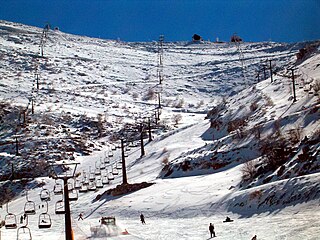
The Mount Hermon ski resort is situated on the south-eastern slopes of Mount Hermon, a few kilometers off the Purple line, in the Israeli-occupied portion of the Golan Heights. The site is surrounded by the Hermon nature reserve. While the nature reserve is open year-round, the ski resort is open only at the peak of winter, when enough snow is accumulated on its ground. It has a top elevation of 2,040 metres (6,690 ft), going down to 1600 metres, with an area covering about 2434 dunams.
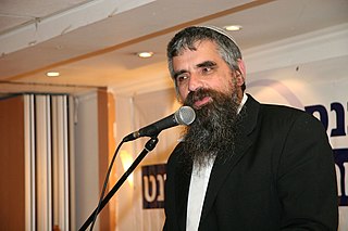
Yuval Cherlow is a Modern Orthodox rabbi and posek. He is Rosh Yeshiva of Yeshivat Hesder Amit Orot Shaul in Tel Aviv, Israel. Cherlow was one of the founders of Tzohar, an organization of religious Zionist Orthodox rabbis in Israel.

Ramat HaHayal is a northeastern neighborhood of Tel Aviv, Israel. Some high tech firms have research and development offices in Ramat HaHayal.

115 Squadron, also known as the Flying Dragon or Red Squadron, is the Israeli Air Force's aggressor squadron. Based at Ovda, it is the sole IAF squadron to operate fixed-wing aircraft, helicopters and also ground-based assets.

The 2011 Israeli border demonstrations started on 15 May 2011, to commemorate what the Palestinians observe as Nakba Day. Various groups of people attempted to approach or breach Israel's borders from the Palestinian-controlled territory, Lebanon, Syria, Egypt and Jordan. At least a dozen people were killed when protesters attempted to cross the border from Syria.
This is a timeline of Israeli history, comprising important legal and territorial changes and political events in Israel and its predecessor states, along with important events which influenced the Zionist movement. To read about the background to these events, see History of Israel. For events predating the Zionist movement, see Timeline of Palestine.

Alon Tal is a current member of the Knesset representing the Blue and White political party. He is a leading Israeli environmental activist and academic; founder of the Israel Union for Environmental Defense and the Arava Institute for Environmental Studies; and co-founder of Ecopeace: Friends of the Earth–Middle East, This Is My Earth, the Israel Forum for Demography, Environment and Society, Aytzim: Ecological Judaism, and the Green Movement. Tal was appointed chair of the department of Public Policy at Tel Aviv University in 2017.
Events in the year 2013 in Israel.

The Golan Heights are a rocky plateau in Western Asia that was captured by Israel from Syria in the 1967 Six-Day War. The international community recognizes the Golan Heights to be official Syrian territory and widely rejects Israeli military occupation. Following the war, Syria dismissed any negotiations with Israel as part of the Khartoum Resolution.

Trump Heights is a planned Israeli settlement in the Israeli-occupied Golan Heights named after and in honor of the 45th President of the United States, Donald Trump. Israeli settlements in the Golan Heights are widely regarded as illegal under international law, but the Israeli government disputes this.