Landsborough Shire Council Chambers

Last updated

Landsborough Shire Council Chambers
LandsboroughShireMuseum.JPG
Landsborough Shire Museum, formerly Landsborough Shire Council Chambers, 2008
Location6 Maleny Street, Landsborough, Sunshine Coast Region, Queensland, Australia
Coordinates 26°48′35″S152°57′53″E / 26.8097°S 152.9647°E / -26.8097; 152.9647 Coordinates: 26°48′35″S152°57′53″E / 26.8097°S 152.9647°E / -26.8097; 152.9647
Design period1919 - 1930s (interwar period)
Built1924
Architect Walter Carey Voller
Architectural style(s) Classicism
Official name: Landsborough Shire Council Chambers (former), Landsborough Shire Historical Museum
Typestate heritage (built)
Designated24 June 1999
Reference no.601915
Significant period1920s-1970s (historical)
1924-ongoing (social)
1920s (fabric)
Significant componentsviews to, council chamber/meeting room, office/s
BuildersAlfred Ernest Round
Australia Queensland location map.svg
Red pog.svg
Location of Landsborough Shire Council Chambers in Queensland
Australia location map.svg
Red pog.svg
Landsborough Shire Council Chambers (Australia)

Landsborough Shire Council Chambers is a heritage-listed former town hall and now museum at 6 Maleny Street, Landsborough, Sunshine Coast Region, Queensland, Australia. It was designed by Walter Carey Voller and built in 1924 by Alfred Ernest Round for the Landsborough Shire Council. It is also known as Landsborough Shire Historical Museum. It was added to the Queensland Heritage Register on 24 June 1999. [1]

Landsborough, Queensland Town in Queensland, Australia

Landsborough is a small town and locality in the Sunshine Coast Region, Queensland, Australia. At the 2011 census, Landsborough had a population of 3,706.

Sunshine Coast Region Local government area in Queensland, Australia

The Sunshine Coast Region is a local government area located in the Sunshine Coast district of South East Queensland, Australia.

Queensland North-east state of Australia

Queensland is the second-largest and third-most populous state in the Commonwealth of Australia. Situated in the north-east of the country, it is bordered by the Northern Territory, South Australia and New South Wales to the west, south-west and south respectively. To the east, Queensland is bordered by the Coral Sea and Pacific Ocean. To its north is the Torres Strait, with Papua New Guinea located less than 200 km across it from the mainland. The state is the world's sixth-largest sub-national entity, with an area of 1,852,642 square kilometres (715,309 sq mi).

Contents

History

The first European settlement was established in the Landsborough, originally known as Mellum Creek, by Isaac Burgess in 1871. His slab hut on the north of Gympie Road near Mellum Creek became a Cobb & Co. staging post on the run to the Gympie gold fields. Settlement of the area expanded particularly with the arrival of the North Coast railway line from Caboolture in 1890. Named Landsborough after the explorer William Landsborough, the Landsborough railway station became the focus for a town centre and the town of Mellum Creek was renamed Landsborough. [1]

Gympie Road, Brisbane road in Brisbane

Gympie Road is a major road in the northern suburbs of Brisbane, Queensland, Australia. The road forms part of the main road route from the Brisbane Central Business District (CBD) to the northern suburbs, Sunshine Coast and east coast of Queensland.

North Coast railway line, Queensland railway line in Queensland, Australia

The North Coast railway line is a narrow gauge railway line in Queensland, Australia. It commences at Roma Street station, Brisbane, and largely parallels the Queensland coast to Cairns in Far North Queensland. The line is electrified between Brisbane and Rockhampton. Along the way, the 1680 km railway passes through the numerous towns and cities of eastern Queensland including Nambour, Bundaberg, Gladstone, Rockhampton, Mackay and Townsville. The line though the centre of Rockhampton runs down the middle of Denison Street.

Caboolture, Queensland Town in Queensland, Australia

Caboolture is a town and suburb in Moreton Bay Region, Queensland, Australia. At the 2016 census, the town of Caboolture had an estimated population of 67,460. It is located on the north side of the Caboolture River, which separates the town from Morayfield and Caboolture South.

Local government for the region was administered by the Caboolture Divisional Board from 1880. The Caboolture Shire, proclaimed in 1903, assumed responsibility for the administration of the regions of Pine Rivers, Landsborough, Kilcoy, Maroochy, Caboolture and Redcliffe. In February 1912, 423 acres (171 ha) were annexed from Caboolture Shire and proclaimed Landsborough Shire. The first Council meeting for the newly formed Shire was held on 20 April 1912. A Council residence and one room office was constructed in 1913 and was used for meetings of the Council until the first purpose-built Chambers was opened in 1924. [1]

Shire of Caboolture Local government area in Queensland, Australia

The Shire of Caboolture was a local government area located in the Australian state of Queensland on the northern urban fringe of the capital, Brisbane, and south of the Sunshine Coast. The Shire covered an area of 1,224.4 square kilometres (472.7 sq mi), of which approximately one-quarter was urban, and existed as a local government entity from 1879 until 2008, when it amalgamated with the City of Redcliffe and Shire of Pine Rivers to form the Moreton Bay Region.

Kilcoy, Queensland Town in Queensland, Australia

Kilcoy is a town and locality in the Somerset Region local government area in South East Queensland, Australia.

Redcliffe, Queensland Suburb of Moreton Bay Region, Queensland, Australia

Redcliffe is a residential suburb of the Moreton Bay Region in the east north-east of the Redcliffe peninsula, approximately 28 kilometres (17 mi) north-north-east of the Brisbane CBD. It serves as the Central Business District for the Redcliffe Peninsula and its surrounding suburbs.

Landsborough Shire Council Chambers, 1932 Landsborough Shire Council Chambers 1932.tiff
Landsborough Shire Council Chambers, 1932

The former Landsborough Shire Council Chambers, designed by architect Walter Carey Voller and constructed by Alfred Ernest Round, accommodated a council chamber, 2 offices, a counter with office space and a walk-in strong room. [1]

WC Voller served his articles under FDG Stanley from 1882 to 1886 and from 1893 operated a productive architectural practice in Brisbane. His most notable work includes St Paul's Presbyterian Church Mackay (1898), St Paul's Church of England Roma (1913), New Farm Methodist Church (1926) and Silkstone Baptist Church (1928). He owned a beach house at Caloundra and he and his family were frequent visitors and well known in the area. [1]

Francis Drummond Greville Stanley Australian architect

Francis Drummond Greville Stanley (1839—1897) was an architect in Queensland, Australia. He was the Queensland Colonial Architect. Many of his designs are now heritage-listed buildings.

Brisbane capital city of Queensland, Australia

Brisbane is the capital of and the most populated city in the Australian state of Queensland, and the third most populous city in Australia. Brisbane's metropolitan area has a population of 2.5 million, and the South East Queensland region, centred on Brisbane, encompasses a population of more than 3.5 million. The Brisbane central business district stands on the historic European settlement and is situated inside a peninsula of the Brisbane River, about 15 kilometres from its mouth at Moreton Bay. The metropolitan area extends in all directions along the floodplain of the Brisbane River Valley between Moreton Bay and the Great Dividing Range, sprawling across several of Australia's most populous local government areas (LGAs)—most centrally the City of Brisbane, which is by far the most populous LGA in the nation. The demonym of Brisbane is "Brisbanite".

Mackay, Queensland City in Queensland, Australia

Mackay is a city and its centre suburb in the Mackay Region on the eastern coast of Queensland, Australia. It is located about 970 kilometres (603 mi) north of Brisbane, on the Pioneer River. Mackay is nicknamed the sugar capital of Australia because its region produces more than a third of Australia's sugar.

In 1967 Landsborough, Maroochy and Noosa Shires became known as the Sunshine Coast. [2]

Shire of Maroochy Local government area in Queensland, Australia

The Shire of Maroochy was a local government area about 100 kilometres (62 mi) north of Brisbane in the Sunshine Coast region of South East Queensland, Australia. The shire covered an area of 1,162.7 square kilometres (448.9 sq mi), and existed as a local government entity from 1890 until 2008, when it amalgamated with its neighbours to the north and south to form the Sunshine Coast Region.

Shire of Noosa Local government area in Queensland, Australia

The Shire of Noosa is a local government area about 130 kilometres (81 mi) north of Brisbane in the Sunshine Coast district of South East Queensland, Australia. The shire covers an area of 868.7 square kilometres (335.4 sq mi). The shire existed as a local government entity from 1910 until 2008, when it was amalgamated with the Shire of Maroochy and City of Caloundra to form the Sunshine Coast Region, and again from 1 January 2014, when it was re-established.

Sunshine Coast, Queensland Region in Queensland, Australia

Sunshine Coast is a peri-urban area and the third most populated area in the Australian state of Queensland. Located 100 km (62 mi) north of the state capital Brisbane in South East Queensland on the Pacific Ocean coastline, its urban area spans approximately 60 km (37 mi) of coastline and hinterland from Pelican Waters to Tewantin. The estimated urban population of Sunshine Coast as at June 2015 was 302,122, making it the 9th most populous in the country.

On 19 December 1987, the Shire of Landsborough was granted city status, and was renamed the City of Caloundra, reflecting the population boom in the coastal section of the City. The Council Chambers were relocated from 77 Bulcock Street, Caloundra to 1 Omrah Avenue, Caloundra in 1995.

The original Landsborough Shire Council Chambers closed in 1974. In 1975 the Landsborough Historical Society secured a lease over the building and in 1975 the building was opened as the Landsborough Shire Historical Museum. [1]

During the 1950s the verandah was extended and enclosed to the east and an extension constructed to the west of the building to accommodate 5 offices. In 1977 the original timber fence was removed and a bullock wagon and two large palms located in the front garden. In 1988, alterations to the former Landsborough Shire Chambers were undertaken during the construction of the large Museum extension to the east. The front verandah was reinstated, office partitioning removed, the building painted and a new roof installed. A covered courtyard link between the early building and the new Museum extension and a roofed storage area to the north butt directly onto the building. [1]

Description

Constructed in 1924 the former Landsborough Shire Council Chambers, a modest, timber building, has a discreet civic presence on Maleny Street, Landsborough. The building is a low-set, hip-roofed, rectangular, timber structure with open front verandah. A narrow skillion-roofed extension has been erected to the west and a large museum courtyard and building has been constructed to the east. [1]

The building and west extension are clad with chamferboards. The picket paling skirt to the front verandah understorey have been replaced with chamferboards. The core of the former Landsborough Shire Council Chambers is symmetrical about a projecting pedimented gabled entry porch reached by a set of open timber stairs. The verandah to the east has been reconstructed but much original fabric remains to the balance of the verandah. A plain curved timber arch with prominent keystone and corbelled ends marks the entry. Four timber clad panels divide the verandah into bays and a plain timber moulded cornice runs around the verandah. The cornice is supported by small timber console brackets to the two mid panels. The front verandah is lined with vertical tongue-and-groove boarding and post and rail framing is exposed to the verandah. The verandah has plain, vertical, timber slat balustrading and blank frieze panels with bottom rails supported by decorative end corbels. The main entry French doors have a clear glass 2-pane fanlight above the doorway and each door has five panels of coloured, textured glass with the top panel arched. [1]

The interior has been altered but the chamber space remains along with much original fabric including the vertical tongue-and-groove lining, post and rail framing, sheeted and battened ceiling, picture rails to the chamber, doors, casement windows and cupboard between the former office and the chamber. [1]

Heritage listing

The former Landsborough Shire Council Chambers was listed on the Queensland Heritage Register on 24 June 1999 having satisfied the following criteria. [1]

The place is important in demonstrating the evolution or pattern of Queensland's history.

Opened in 1924, the former Landsborough Shire Council Chambers, a modest, low-set, single-storey timber building on Maleny Street, Landsborough, was the first purpose-built council chambers for the Landsborough Shire Council. Although the building has been altered and has received a major extension, the original form is evident. [1]

The place is important in demonstrating the principal characteristics of a particular class of cultural places.

The place is important for its association with the work of architect Walter Carey Voller. [1]

The place is important because of its aesthetic significance.

Residential in scale, the building contributes a dignified civic presence to the streetscape. [1]

The place has a strong or special association with a particular community or cultural group for social, cultural or spiritual reasons.

Sustaining a local government presence from 1924 to 1974, the former Landsborough Shire Council Chambers is important for its association with the Landsborough Shire Council and the local community and illustrates the development of local government in the region. [1]

Related Research Articles

Caloundra Town in Queensland, Australia

Caloundra is the southernmost town in the Sunshine Coast Region in South East Queensland, Australia.

Landsborough railway station

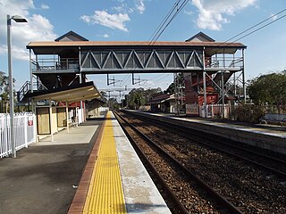
Landsborough railway station is located on the North Coast line in Queensland, Australia. It serves the town of Landsborough in the Sunshine Coast Region.

City of Caloundra Local government area in Queensland, Australia

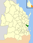
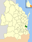
The City of Caloundra was a local government area about 90 kilometres (56 mi) north of Brisbane in the Sunshine Coast region of South East Queensland, Australia. The shire covered an area of 1,093.1 square kilometres (422.0 sq mi), and existed as a local government entity from 1912 until 2008, when it amalgamated with councils further north to form the Sunshine Coast Region.

Cardwell Bush Telegraph

Cardwell Bush Telegraph is a heritage-listed former post office and now heritage centre at 53 Victoria Street, Cardwell, Cassowary Coast Region, Queensland, Australia. The Telegraph and Post Office at Cardwell was designed by Colonial Architect's Office and built in 1870 by George McCallum, making it one of the oldest buildings in North Queensland.

Ithaca Town Council Chambers

The Ithaca Town Council Chambers is a heritage-listed former town hall of the former local government area of the Town of Ithaca, and now a community centre in Paddington, City of Brisbane, Queensland, Australia. Located at 99 Enoggera Terrace, Red Hill, it was designed by Atkinson and McLay and built in 1910 by Charles Thomas Hall and Francis Joseph Mayer. It is also known as Ithaca Library and Red Hill Kindergarten. It was added to the Queensland Heritage Register on 24 March 2000.

Pittsworth Shire Council Chambers and Shire Hall

Pittsworth Shire Council Chambers and Shire Hall is a heritage-listed former town hall at Short Street, Pittsworth, Toowoomba Region, Queensland, Australia. It was built from 1913 to 1914 by John Fortune. It is also known as Pittsworth Kindergarten. It was added to the Queensland Heritage Register on 28 May 1999.

Cook Shire Hall

Cook Shire Hall is a heritage-listed community hall at Helen Street, Cooktown, Shire of Cook, Queensland, Australia. It was built from 1907. It is also known as Cooktown Presbyterian Church, Oddfellows Hall, and Standen's Hall. It was added to the Queensland Heritage Register on 8 April 1997.

Pine Rivers Shire Hall

Pine Rivers Shire Hall is a heritage-listed town hall at 238 Gympie Road, Strathpine, Moreton Bay Region, Queensland, Australia. It was built from 1889 to 1935. It is also known as Pine Divisional Board Hall, Pine Rivers Shire Hall, and Pine Shire Hall. It was added to the Queensland Heritage Register on 21 October 1992.

Buderim House

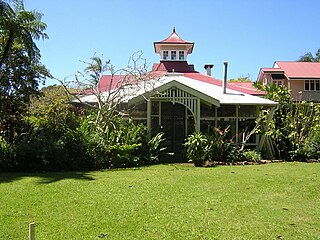
Buderim House is a heritage-listed homestead at 10 Orme Road, Buderim, Sunshine Coast Region, Queensland, Australia. It was designed by George Trotter and built c. 1915 by Christian Schriver. It was added to the Queensland Heritage Register on 2 March 1993.

Bankfoot House

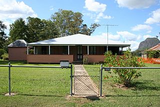
Bankfoot House is a heritage-listed homestead at 1998 Old Gympie Road, Glass House Mountains, Sunshine Coast Region, Queensland, Australia. It was built in 1878. It was added to the Queensland Heritage Register on 11 December 2008.

Fairview, Maleny

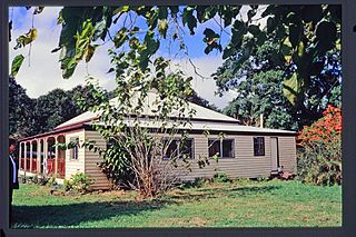
Fairview is a heritage-listed house at 15 Porter's Lane, Maleny, Sunshine Coast Region, Queensland, Australia. It was designed and built in 1907 by the Pattemore family. It is also known as Armstrong's House and Pattemore House. It was added to the Queensland Heritage Register on 4 September 2003.

Burdekin Shire Council Chambers

Burdekin Shire Council Chambers is a heritage-listed town hall at 145 Young Street, Ayr, Shire of Burdekin, Queensland, Australia. It was designed by Frederick Smith and built in 1937 by local builder AS Wight. It is also known as Ayr Shire Council Chambers. It was added to the Queensland Heritage Register on 13 October 1997.

Cairns City Council Chambers

Cairns City Council Chambers is a heritage-listed former town hall and now council library at 151 Abbott Street, Cairns, Cairns Region, Queensland, Australia. It was designed by Hill & Taylor and built from 1929 to 1930 by Alex McKenzie. It was added to the Queensland Heritage Register on 5 October 1998. It is now home to the Cairns City Library.

Mulgrave Shire Council Chambers

Mulgrave Shire Council Chambers is a heritage-listed former town hall at 51 The Esplanade, Cairns, Cairns Region, Queensland, Australia. It was designed by Charles Dalton Lynch & Walter Hunt and built from 1912 to 1913 by Wilson & Baillie. It is also known as Cairns Shire Offices. It was added to the Queensland Heritage Register on 6 January 1999.

Cook Shire Council Chambers

Cook Shire Council Chambers is a heritage-listed former town hall and now museum at 121 Charlotte Street, Cooktown, Shire of Cook, Queensland, Australia. It was built from 1876 to 1877 by Henry J Meldrum and John Sullivan. It was also known as Cooktown Post and Telegraph Office and is now known as Cooktown History Centre. It was added to the Queensland Heritage Register on 8 April 1997.

Landsborough Shire Museum Local history museum and social museum in Queensland, Australia

The Landsborough Shire Historical Museum is a local history and social history museum located in the Sunshine Coast town of Landsborough in Queensland, Australia. The museum explicitly houses and records the local history of the former Landsborough shire and includes the centre of Caloundra and is housed in the Heritage listed Landsborough Shire Council Chambers on Maleny Street.

Tambo Post Office

Tambo Post Office is a heritage-listed former post office and now museum at Arthur Street, Tambo, Blackall-Tambo Region, Queensland, Australia. It was built in 1876 and 1885. It is also known as Post and Telegraph Office Tambo and Tambo Telecommunications Museum. It was added to the Queensland Heritage Register on 21 October 1992.

References

  1. 1 2 3 4 5 6 7 8 9 10 11 12 13 14 15 "Landsborough Shire Council Chambers (former) (entry 601915)". Queensland Heritage Register . Queensland Heritage Council. Retrieved 1 August 2014.
  2. "Sunshine Coast (entry 32861)". Queensland Place Names. Queensland Government . Retrieved 25 July 2015.

Attribution

CC-BY-icon-80x15.png This Wikipedia article was originally based on "The Queensland heritage register" published by the State of Queensland under CC-BY 3.0 AU licence (accessed on 7 July 2014, archived on 8 October 2014). The geo-coordinates were originally computed from the "Queensland heritage register boundaries" published by the State of Queensland under CC-BY 3.0 AU licence (accessed on 5 September 2014, archived on 15 October 2014).

Commons-logo.svg Media related to Landsborough Shire Council Chambers at Wikimedia Commons