History
The bay is known for the Langdon Bay Hoard – a collection of Bronze Age metal objects found nearby in 1974. [1] This includes bronze axes of a French type [2] and is thought to represent the cargo of a boat that was caught in a storm just after leaving the English coast, either jettisoned to lighten and save the boat or sunk with it (if there was a wreck, it is now lost). This demonstrates that cross-channel trade was already occurring in the Bronze Age, if not earlier. The hoard is owned by the British Museum, but is on long-term loan and display in Dover Museum in Market Square, Dover.
Three searchlight batteries – known as the Langdon Lights – were built into the base of the bay's cliffs during World War II, so that any ship trying to enter the bay could be illuminated while it was checked, though one battery has since been destroyed by a cliff fall. [3]
The area above the cliffs is now a chalk downland nature reserve owned by the National Trust, looking down on Dover Harbour and the Channel, and centred on the 'Gateway to the White Cliffs' Visitor Centre. Large parts of this reserve, and of this section of clifftop in general, is an SSSI, AONB and Heritage Coast. [4] Another nearby historic site is the South Foreland Lighthouse, also a NT property.

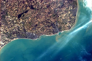
Dover is a town and major ferry port in Kent, South East England. It faces France across the Strait of Dover, the narrowest part of the English Channel at 33 kilometres (21 mi) from Cap Gris Nez in France. It lies south-east of Canterbury and east of Maidstone. The town is the administrative centre of the Dover District and home of the Port of Dover.

Sandwich is a town and civil parish in the Dover District of Kent, south-east England. It lies on the River Stour and has a population of 4,985. Sandwich was one of the Cinque Ports and still has many original medieval buildings, including several listed public houses and gates in the old town walls, churches, almshouses and the White Mill. While once a major port, it is now 2 miles (3 km) from the sea due to the disappearance of the Wantsum Channel. Its historic centre has been preserved. Sandwich Bay is home to nature reserves and two world-class golf courses, Royal St George's and Prince's. The town is also home to many educational and cultural events. Sandwich also gave its name to the food by way of John Montagu, 4th Earl of Sandwich, and the word sandwich is now found in several languages.

The Bristol Channel is a major inlet in the island of Great Britain, separating South Wales and South West England. It extends from the smaller Severn Estuary of the River Severn to the North Atlantic Ocean. It takes its name from the English city and port of Bristol.

Dover is a local government district in Kent, England. It is named after its largest town, the port town of Dover. The council is based in Whitfield on the outskirts of Dover. The district also covers the towns of Deal, Sandwich, Walmer and the surrounding rural areas.

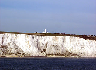
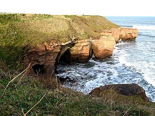
The White Cliffs of Dover are the region of English coastline facing the Strait of Dover and France. The cliff face, which reaches a height of 350 feet (110 m), owes its striking appearance to its composition of chalk accented by streaks of black flint, deposited during the Late Cretaceous. The cliffs, on both sides of the town of Dover in Kent, stretch for eight miles (13 km). The White Cliffs of Dover form part of the North Downs. A section of coastline encompassing the cliffs was purchased by the National Trust in 2016.

The Western Heights of Dover are one of the most impressive fortifications in Britain. They comprise a series of forts, strong points and ditches, designed to protect the country from invasion. They were created in the 18th and 19th centuries to augment the existing defences and protect the key port of Dover from both seaward and landward attack; by the start of the 20th century Dover Western Heights was collectively reputed to be the 'strongest and most elaborate' fortification in the country. The Army finally withdrew from the Heights in 1956–61; they are now a local nature reserve.

Martin Mill is a village in east Kent, England. It takes its name from the nearby village of Martin. Martin Mill railway station is on the Dover to Deal railway line. The population of the village was, similarly to Martin, included in the civil parish of Langdon.
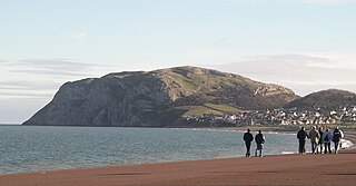
The Little Orme is 141 metres (463 ft) in height, and is a HuMP. It is one of two headlands situated at either end of Llandudno Bay, in Conwy County Borough, Wales. The other, larger, headland is the Great Orme. It has two summits, the higher with a trig point.
South Foreland is a chalk headland on the Kent coast of southeast England. It presents a bold cliff to the sea, and commands views over the Strait of Dover. It is centred 3 miles (4.8 km) northeast of Dover and 15 miles south of North Foreland. It includes the closest point on the Island of Britain to the European mainland at a distance of 20.6 miles (33.2 km).

Dover Museum is a museum in Dover, Kent, in south-east England.

The Saxon Shore Way is a long-distance footpath in England. It starts at Gravesend, Kent, and traces the coast of South-East England as it was in Roman times as far as Hastings, East Sussex, 163 miles (262 km) in total. This means that around Romney Marsh the route runs significantly inland from the modern coastline.
The River Dour is a chalk stream in the county of Kent, England. It flows from the villages of Temple Ewell and River between which is a neighbourhood served by a railway station, Kearsney. It is roughly 4 miles (6.4 km) long.

The Port of Dover is a cross-channel ferry, cruise terminal, maritime cargo and marina facility situated in Dover, Kent, south-east England. It is the nearest English port to France, at just 34 kilometres (21 mi) away, and is one of the world's busiest maritime passenger ports, with 11.7 million passengers, 2.6 million lorries, 2.2 million cars and motorcycles and 80,000 coaches passing through it in 2017, and with an annual turnover of £58.5 million a year. This contrasts with the nearby Channel Tunnel, the only fixed link between the island of Great Britain and the European mainland, which now handles an estimated 20 million passengers and 1.6 million trucks per year.

The Dover Bronze Age boat is one of fewer than 20 Bronze Age boats so far found in Britain. It dates to 1575–1520 BC, which may make it one of the oldest substantially intact boat in the world – though much older ships exist, such as the Khufu ship from 2500 BC. The boat was made using oak planks sewn together with yew lashings. This technique has a long tradition of use in British prehistory; the oldest known examples are the narrower Ferriby boats from east Yorkshire. A 9.5m long section of the boat is on display at Dover Museum.
The History of Dover, because of the town's proximity to the Continent begins when Stone Age people crossed what was then a land bridge, before the opening up of the English Channel. Since then, successive invasions of peoples have taken place. Archaeological finds have revealed a great deal, particularly about cross channel trade and the attempts of those various inhabitants to build large-scale defences against European invaders on this part of the English coast.
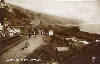
Folkestone Warren Halt was a station on the South Eastern Main Line of the South Eastern Railway at the beach location known as "The Warren" in the east end of Folkestone, Kent, now within the East Cliff and Warren Country Park.
The history of Folkestone stretches back to ancient times, with evidence of human habitation dating to the Mesolithic and Paleolithic ages over 12,000 years ago. Its close proximity to the Continent means that it has often been a point of transit for migrating peoples. The area has successively been occupied by groups of Britons, Romans and Saxons. During the Iron Age, a large oppidum and quern-stone workshop were situated on the eastern headlands of the bay. By the Roman era, it had been transformed into a large Roman Villa overlooking the sea.

East Cliff and Warren Country Park is in Folkestone, in Kent, England. This country park is formed of the East Cliffs of Folkestone, the sandy beaches of East Wear Bay and the land-slipped nature reserve land between the cliffs and the sea.
The Berwickshire Coastal Path is a walking route some 48 kilometres (30 mi) long. It follows the eastern coastline of Scotland from Cockburnspath in the Scottish Borders to Berwick upon Tweed, just over the border in England. At Cockburnspath the path links with the Southern Upland Way and the John Muir Way.

Fan Bay Deep Shelter is a series of tunnels constructed during World War II as accommodation for Fan Bay Battery artillery battery, 23 metres down in the White Cliffs of Dover at Fan Bay near the Port of Dover. The tunnels and gun battery were built by the Royal Engineers between 20 November 1940 and 28 February 1941. The site is maintained by the National Trust.
