
South Gloucestershire is a unitary authority area in the ceremonial county of Gloucestershire, South West England. Towns in the area include Yate, Chipping Sodbury, Thornbury, Filton, Patchway and Bradley Stoke. The southern part of its area falls within the Greater Bristol urban area surrounding the city of Bristol.
Olveston is a small village and larger parish in South Gloucestershire, England. The parish comprises the villages of Olveston and Tockington, and the hamlets of Old Down, Ingst and Awkley. The civil parish population at the 2011 census was 2,033. Alveston became a separate church parish in 1846. The district has been inhabited since the Stone Age, and the salt marshes that made up almost half of the parish, were progressively drained in Roman and Saxon times. A sea wall was constructed at the same time to prevent flooding from the nearby estuary of the River Severn.

Elberton is a small village and former civil parish, now in the parish of Aust, in the South Gloucestershire district, in the ceremonial county of Gloucestershire, England. In 1931 the parish had a population of 137.
Northavon was, from 1983 until 2010, a constituency represented in the House of Commons of the Parliament of the United Kingdom. It elected one Member of Parliament (MP) by the first past the post system of election.
Littleton-upon-Severn is a village and former civil parish, now in the parish of Aust, in the South Gloucestershire district, in the ceremonial county of Gloucestershire, England, near the mouth of the River Severn and is located to the west of Thornbury. Historically it belonged to the Hundred of Langley and Swinehead. In 1931 the parish had a population of 179. On 1 April 1935 the parish was abolished and merged with Aust.

Frampton Cotterell is a large village and parish, in South Gloucestershire, South West England, on the River Frome. The village is contiguous with Winterbourne to the south-west and Coalpit Heath to the east. The parish borders Iron Acton to the north and Westerleigh to the south-east, the large town of Yate is 2.1 miles (3.4 km) away. The village is 7.5 miles (12 km) north-east of the city of Bristol.

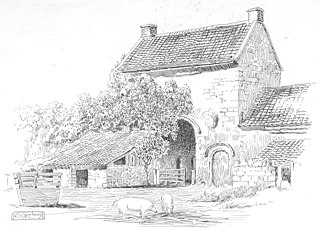
Gaunt's Earthcott, sometimes spelt Gaunts Earthcott, is a hamlet in the civil parish of Almondsbury in South Gloucestershire, England. It consists of a ruined chapel, a few houses and two farms, Green Farm and Court Farm. The village is located approximately 2.5 miles (4 km) from Rudgeway and the A38 road and about the same distance from Frampton Cotterell and Winterbourne. The village is located close to the interchange between the M4 and M5 motorways. There is no real industry as such and the main economic activity in the area is farming.

The Diocese of Bristol is an ecclesiastical jurisdiction or diocese of the Church of England in the Province of Canterbury, England. It is based in the city of Bristol and covers South Gloucestershire and parts of north Wiltshire, as far east as Swindon. The diocese is headed by the Bishop of Bristol and the Episcopal seat is located at the Cathedral Church of the Holy and Undivided Trinity, commonly known as Bristol Cathedral.

The Gloucestershire County Football League is a football league in England, founded in 1968. The league is affiliated to the Gloucestershire County FA.

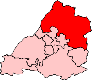
Thornbury and Yate is a constituency represented in the House of Commons of the UK Parliament since the 2015 election by Luke Hall, a member of the Conservative Party. Encompassing an area to the north-east of Bristol, it is one of three constituencies that make up the South Gloucestershire Unitary Authority Area, along with Filton and Bradley Stoke and Kingswood.

West Gloucestershire was a parliamentary constituency in Gloucestershire, represented in the House of Commons of the Parliament of the United Kingdom.
The BS postcode area, also known as the Bristol postcode area, is a group of 37 postcode districts in South West England, within eight post towns. These cover the city of Bristol, north Somerset and south Gloucestershire.
Barton Regis was, from 1894 to 1904, a rural district in the English administrative county of Gloucestershire, adjacent to the City of Bristol.

Barton Regis was an ancient hundred of Gloucestershire, England. Hundreds originated in the late Saxon period as a subdivision of a county and lasted as administrative divisions until the 19th century.
Pucklechurch was an ancient hundred of Gloucestershire, England. Hundreds originated in the late Saxon period as a subdivision of a county and lasted as administrative divisions until the 19th century.
Henbury Hundred was a subdivision of the county of Gloucestershire, England. Hundreds originated in the late Saxon period and lasted as administrative divisions until the 19th century.
Grumbald's Ash Hundred was a subdivision of the county of Gloucestershire, England. Hundreds originated in the late Saxon period and lasted as administrative divisions until the 19th century. It has been reported that the court was originally held under an Ash tree situated in Doddington parish, although this location would not be consistent with the previous split of hundred. Its name survives in the Grumbolds Ash with Avening electoral ward of Cotswold district council.
