St Briavels Hundred

Last updated

Gloucestershire Hundreds in 1832 Gloucestershire 1832 Map.png
Gloucestershire Hundreds in 1832

St Briavels was an ancient hundred of Gloucestershire, England. It comprised the extra-parochial area of the Forest of Dean, and the ancient parishes of

Gloucestershire County of England

Gloucestershire is a county in South West England. The county comprises part of the Cotswold Hills, part of the flat fertile valley of the River Severn, and the entire Forest of Dean.

In England and Wales, an extra-parochial area, extra-parochial place or extra-parochial district was a geographically defined area considered to be outside any ecclesiastical or civil parish. Anomalies in the parochial system, they had no church or clergymen and were therefore exempt from payment of poor or church rates and usually tithes. They were formed for a variety of reasons, often because an area was unpopulated or unsuitable for agriculture, but also around institutions and buildings or natural resources. Extra-parochial areas caused considerable problems when they became inhabited as they did not provide religious facilities, local governance or provide for the relief of the poor. Their status was often ambiguous and there was demand for extra-parochial areas to operate more like parishes. Following the introduction of the New Poor Law, extra-parochial areas were effectively made civil parishes by the Extra-Parochial Places Act 1857 and were eliminated by the Poor Law Amendment Act 1868. This was achieved either by being integrated with a neighbouring or surrounding parish, or by becoming a separate civil parish if the population was high enough.

Forest of Dean geographical, historical and cultural region in Gloucestershire, England

The Forest of Dean is a geographical, historical and cultural region in the western part of the county of Gloucestershire, England. It forms a roughly triangular plateau bounded by the River Wye to the west and northwest, Herefordshire to the north, the River Severn to the south, and the City of Gloucester to the east.

Abenhall village in United Kingdom

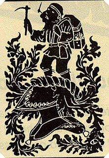
Abenhall is a small village in the English county of Gloucestershire, lying on the road between Mitcheldean and Flaxley in the Forest of Dean. The parish includes the settlement of Plump Hill, which is actually more populous than Abenhall itself, and was once part of the Hundred of St Briavels. Originally a mining and iron-making centre like much of the surrounding area, the village is notable for its 14th century Church of St Michael, which is built of local red sandstone and has ornate contemporary carvings relating to the Forest of Dean's principal industries. These include a shield bearing the arms of the Freeminers on the west wall and a mid-15th century octagonal font, that has tools of miners and metalworkers incised on its sides. Abenhall is a tiny, ancient village in a secluded quiet valley near Mitcheldean. The parish includes the settlement of Plump Hill, on the Mitcheldean to Cinderford Road as it climbs into the high Forest. Abenhall is on the Flaxley to Mitcheldean Road. Originally a mining and iron making centre, it is notable for its 14th century Church of St Michael, which is built of local red sandstone and has excellent contemporary carvings relating to the Forest of Dean's industries. These include a shield bearing the arms of the Freeminers on the west wall and the fabulous mid-15th century octagonal font, that has tools of miners and metalworkers incised on its sides. In the west tower is a spectacular new window installed 14 April 2011 by stained glass artist Thomas Denny; presented by the current free miners of the Forest of Dean to represent their gratitude and present day continuation of the ancient local customs of coal, iron ore and stone mining.

English Bicknor village in the United Kingdom

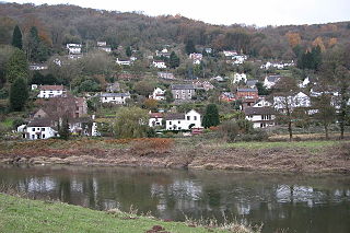
English Bicknor is a village and civil parish in the Forest of Dean district of west Gloucestershire, England. The 2011 Census recorded the population as 408. The village is near the county boundary with Herefordshire, opposite which is the village of Welsh Bicknor. The two villages are on opposite sides of the River Wye.

St Briavels village in United Kingdom

St Briavels is a medium-sized village and civil parish in the Royal Forest of Dean in west Gloucestershire, England; close to the England-Wales border, and 5 miles (8 km) south of Coleford. It stands almost 800 feet (240 m) above sea level on the edge of a limestone plateau above the valley of the River Wye, above an ancient meander of the river. To the west, Cinder Hill drops off sharply into the valley.

The hundred was created at some time between 1086 and 1220 to provide a structure for the administration of the Forest of Dean. The meeting place was St Briavels Castle. [1]

St Briavels Castle Grade I listed castle in Forest of Dean, United Kingdom

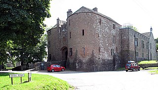
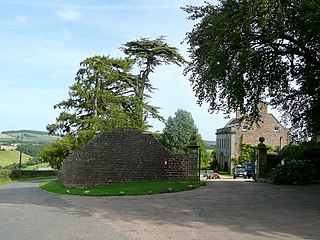
St Briavels Castle is a moated Norman castle at St Briavels in the English county of Gloucestershire. The castle is noted for its huge Edwardian gatehouse that guards the entrance.

Related Research Articles

Forest of Dean District Non-metropolitan district in England

Forest of Dean is a local government district in Gloucestershire, England, named after the Forest of Dean. Its council is based in Coleford. Other towns and villages in the district include Blakeney, Cinderford, Drybrook, English Bicknor, Huntley, Littledean, Longhope, Lea, Lydbrook, Lydney, Mitcheldean, Newnham and Newent

Puzzlewood ancient woodland site, near Coleford in the Forest of Dean, Gloucestershire, England

Puzzlewood is an ancient woodland site and tourist attraction, near Coleford in the Forest of Dean, Gloucestershire, England. The site, covering 14 acres (5.7 ha), shows evidence of open cast iron ore mining dating from the Roman period, and possibly earlier.

Lydney was a rural district in Gloucestershire, England from 1894 to 1974. It covered an area on the Welsh border by the Severn estuary.

Llandogo village in United Kingdom

Llandogo is a small village in Monmouthshire, south Wales, between Monmouth and Chepstow in the lower reaches of the Wye Valley AONB, two miles north of Tintern. It is set on a steep hillside overlooking the River Wye and across into the Forest of Dean in Gloucestershire, England.

Freeminer

Freeminer is an ancient title given to coal or iron miners in the Forest of Dean, Gloucestershire, England, who have earned the right to mine personal plots, known as gales.

Clearwell village in United Kingdom

Clearwell is a village and former ancient manor in the Forest of Dean, West Gloucestershire, England. A recent survey indicated that the population of Clearwell is approximately 350.

Brockweir village in United Kingdom

Brockweir is a small village on the eastern bank of the River Wye, within the Forest of Dean, Gloucestershire, England. A road bridge links it across the river to Monmouthshire, Wales, about a mile (1.6 km) outside the village of Tintern and 7 12 miles (12.1 km) north of Chepstow. The village is close to both the Offa's Dyke Path and the Wye Valley Walk.

East Dean was a township, and later civil parish, in Gloucestershire, England. It was created as a township in 1844 and abolished as a civil parish in 1953. Its former area is now part of the Forest of Dean district.

Awre for Blakeney railway station is a closed railway station situated in Gloucestershire, England. As well as the village of Awre it served the town of Blakeney, Gloucestershire

Tidenham Station was the station for the village of Tidenham on the former Wye Valley Railway. It was opened in 1876 during the construction of the line and closed on 5 January 1959 following the closure of the line to passenger services. The next station on the line was Netherhope Halt.

St Briavels Station was a station along the Wye Valley Railway. It was built in 1876 during the construction of the line on the Monmouthshire side of the River Wye at Bigsweir, and was intended to serve the nearby villages of St Briavels, across the river in the Forest of Dean, and Llandogo, which is further down the Wye Valley. It was closed on 5 January 1959 when the line was closed to passenger services. St Briavels station was renamed three time during its life: firstly Bigsweir Station, then St Briavels and Llandogo Station, and finally St Briavels Station.

<i>Gloucestershire Victoria County History</i>

Gloucestershire Victoria County History is an encyclopaedic history of the county of Gloucestershire in England. It forms part of the overall Victoria County History of England founded in 1899 in honour of Queen Victoria. With twelve volumes published in the series A History of the County of Gloucestershire, the Gloucestershire Victoria County History is about halfway through its history of all the parishes in the county. Ten volumes have been published to date, and a further four volumes are in preparation.

Sir Baynham Throckmorton, 3rd Baronet Member of the Parliament of England

Sir Baynham Throckmorton, 3rd Baronet of Clearwell, Gloucestershire was an English politician who sat in the House of Commons at various times between 1656 and 1679.

Bledisloe Hundred

Bledisloe was an ancient hundred of Gloucestershire, England. It comprised the ancient parishes of

Eastbach Court

Eastbach Court is a historic Grade II mansion in English Bicknor, Gloucestershire, England.

Samuel Blackwell was a British politician who sat in the House of Commons from 1774 to 1784.

References

  1. C R J Currie, N M Herbert (Editors), A P Baggs, A R J Jurica (1996). "St. Briavels Hundred". A History of the County of Gloucester: Volume 5: Bledisloe Hundred, St. Briavels Hundred, The Forest of Dean. Institute of Historical Research. Retrieved 9 July 2011.CS1 maint: multiple names: authors list (link)

Coordinates: 51°47′N2°37′W / 51.79°N 2.61°W / 51.79; -2.61

Geographic coordinate system Coordinate system

A geographic coordinate system is a coordinate system that enables every location on Earth to be specified by a set of numbers, letters or symbols. The coordinates are often chosen such that one of the numbers represents a vertical position and two or three of the numbers represent a horizontal position; alternatively, a geographic position may be expressed in a combined three-dimensional Cartesian vector. A common choice of coordinates is latitude, longitude and elevation. To specify a location on a plane requires a map projection.