Langset (Saltdal)

Last updated
Langset
Village
Norway Nordland location map.svg
Red pog.svg
Langset
Location in Nordland
Norway location map.svg
Red pog.svg
Langset
Langset (Norway)
Coordinates: 67°08′12″N15°27′06″E / 67.13667°N 15.45167°E / 67.13667; 15.45167 Coordinates: 67°08′12″N15°27′06″E / 67.13667°N 15.45167°E / 67.13667; 15.45167
Country Norway
Region Northern Norway
County Nordland
District Salten
Municipality Saltdal
Elevation [1] 44 m (144 ft)
Time zone CET (UTC+01:00)
  Summer (DST) CEST (UTC+02:00)
Post Code8250 Rognan

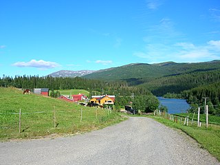
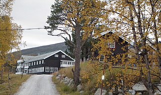
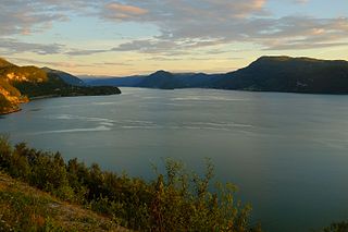
Langset (Lule Sami : Laŋsæhtta) [1] is a basic statistical unit in the sub-area of Nedre Saltdal ('Lower Saltdal') in the municipality of Saltdal in Nordland county, Norway. The area is located north of Rognan and Saksenvik and south of Setså on the east side of Saltdal Fjord (Saltdalsfjorden). European route E6 and the Nordland Line pass through the area. [2] [3]

Lule Sami language language

Lule Sámi language(julevsámegiella) is a Uralic, Sámi language spoken in Lule Lappmark, i.e. around the Lule River, Sweden and in the northern parts of Nordland county in Norway, especially Tysfjord municipality, where Lule Sámi is an official language. It is written in the Latin script, having an official alphabet.

The basic statistical unit is a type of statistical unit used by Statistics Norway to provide stable and coherent geographical units for regional statistics in Norway. Basic statistical units are subdivisions of municipalities, and cover generally homogeneous areas. Most basic statistical units include a few hundred inhabitants, but as their borders are near constant, this can vary widely over time.

Saltdal Municipality in Nordland, Norway

Saltdal is a municipality in Nordland county, Norway. It is part of the traditional district of Salten. The administrative centre of the municipality is the village of Rognan. Other villages in Saltdal include Røkland and Lønsdal.

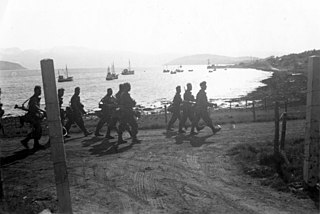
During the Second World War the Blood Road was built through the area. [4] It was constructed as a new segment of Norwegian National Road 50 between Rognan and Langset, where there was ferry service before the war. [3]

German occupation of Norway Nazi occupation of Norway during World War II

The German occupation of Norway during World War II began on 9 April 1940 after German forces invaded the neutral Scandinavian country of Norway. Conventional armed resistance to the German invasion ended on 10 June 1940 and the Germans controlled Norway until the capitulation of German forces in Europe on 8/9 May 1945. Throughout this period, Norway was continuously occupied by the Wehrmacht. Civil rule was effectively assumed by the Reichskommissariat Norwegen, which acted in collaboration with a pro-German puppet government, the Quisling regime, while the Norwegian King Haakon VII and the prewar government escaped to London, where they acted as a government in exile. This period of military occupation is in Norway referred to as the "war years" or "occupation period".

Blood Road

The Blood Road is a route northeast of Rognan in the municipality of Saltdal in Nordland county, Norway that was built by prisoners during the Second World War. The route was a new section of Norwegian National Road 50 between Rognan and Langset on the east side of Saltdal Fjord (Saltdalsfjorden), where there was a ferry service before the war. The specific incident that gave the road its name was a cross of blood that was painted on a rock cutting in June 1943. The blood came from a prisoner that was shot along the route, and the cross was painted by his brother.

European route E6 highway in Sweden and Norway

European route E6 is the main north-south road through Norway, and the west coast of Sweden. It is 3 088 km long and runs from the southern tip of Sweden at Trelleborg, into Norway and through almost all of the country north to the Arctic Circle and Nordkapp. The route ends in Kirkenes close to the Russian border.

Related Research Articles

Nordland County (fylke) of Norway

Nordland is a county in Norway in the Northern Norway region, bordering Troms in the north, Trøndelag in the south, Norrbotten County in Sweden to the east, Västerbotten County to the southeast, and the Atlantic Ocean to the west. The county was formerly known as Nordlandene amt. The county administration is in Bodø. The remote Arctic island of Jan Mayen has been administered from Nordland since 1995.

Fauske Municipality in Nordland, Norway

Fauske (Norwegian) or Fuossko (Lule Sami) is a municipality located in Nordland county, Norway. It is part of the traditional district of Salten. The administrative centre of the municipality is the town of Fauske. Some of the villages in Fauske include Nystad, Venset, Straumsnes, and Sulitjelma.

Rognan Village in Northern Norway, Norway

Rognan is a village and the administrative centre of the municipality of Saltdal in Nordland county, Norway. The village is located at the innermost part of Skjerstad Fjord, called Saltdal Fjord. It is located about 15 kilometres (9.3 mi) north of the village of Røkland.

Sverre Granlund Norwegian soldier

Corporal Sverre Granlund, DCM was a Norwegian commando during the Second World War.

Dunderland Valley valley in Rana, Norway

The Dunderland Valley is a valley in the municipality of Rana in Nordland county, Norway. It reaches from just below the eastern Saltfjellet plateau about 8 miles (13 km) south of the Arctic circle. The mountain Bolna is situated in the uppermost boundary of the valley which then proceeds to the southwest all the way down to the Ranfjorden. Some of the minor side valleys include Plurdalen, Røvassdalen, Bjøllådalen, Grønfjelldalen and Virvassdalen. The valley also includes several villages such as Krokstrand, Bjøllånes, Storvoll, Dunderland, Eiterå, Nevernes, Storforshei, Nevermoen and Røssvoll.

Røkland Village in Northern Norway, Norway

Røkland is a village in the municipality of Saltdal in Nordland county, Norway. The village is located along the Saltdalselva river about 15 kilometres (9.3 mi) south of the municipal centre of Rognan. European route E06 and the Nordland Line both pass through the village. Røkland Station is a train station along the Nordland Line.

Lønsdal Village in Northern Norway, Norway

Lønsdal is a village in the municipality of Saltdal in Nordland county, Norway. The village is located in the Lønsdal valley, along the Lønselva river. European route E06 highway and the Nordland Line both pass through the village. The village also has a train station on the Nordland Line, about halfway between Dunderland Station and Røkland Station.

Saltfjellet mountain range in Nordland, Norway

Saltfjellet is a mountain area in Nordland county, Norway that separates the two regions of Helgeland and Salten. It is also a cultural border between the Southern and Central parts of Sápmi.

Bernhoff Otelius Hansen was a Norwegian wrestler who competed in the 1904 Summer Olympics for the United States.

Skjerstad Fjord fjord in Nordland county, Norway

Skjerstad Fjord is a fjord in the municipalities of Bodø, Fauske, and Saltdal in Nordland county, Norway. It is a 40-kilometre (25 mi) long arm off of the main Saltfjorden. It is connected to the Saltfjorden by the narrow Saltstraumen strait, which has very strong tidal currents. The villages of Valnesfjord and Rognan and the town of Fauske lie along the shores of the fjord. European route E06 runs along the eastern shore of the fjord, and the Nordland Line follows the eastern and northern shores of the fjord. The Misværfjorden branches off this fjord to the south at the village of Skjerstad.

Saltdal Church Church in Nordland, Norway

Saltdal Church is a parish church of the Church of Norway in Saltdal Municipality in Nordland county, Norway. It is located in the village of Rognan. It is the main church for the Saltdal parish which is part of the Salten prosti (deanery) in the Diocese of Sør-Hålogaland. The white, wooden church was built in a long church style in 1864 by the architect Peter Høier Holtermann. The church seats about 380 people.

Øvre Saltdal Church Church in Nordland, Norway

Øvre Saltdal Church is a parish church of the Church of Norway in Saltdal Municipality in Nordland county, Norway. It is located in the village of Røkland. It is one of two churches for the Saltdal parish which is part of the Salten prosti (deanery) in the Diocese of Sør-Hålogaland. The red, wooden church was built in a long church style in 1938 by the architect Andreas W. Nygaard. The church seats about 200 people.

Rognan Airport airport in Saltdal, Norway

Rognan Airport is a private airport situated in the village of Rognan in the municipality of Saltdal in Nordland county, Norway. The municipal airport features a 735-meter (2,411 ft) grass runway aligned 01/19. It is used for recreational flying and is operated by Saltdal Flyklubb.

Actions in Nordland

The Actions in Nordland were part of the Norwegian Campaign of World War II. They were a subsidiary part of the Allied attempt to recapture Narvik.

Saltdal Fjord fjord in Saltdal, Norway

Saltdal Fjord is a fjord arm of Skjerstad Fjord in the municipality of Saltdal in Nordland county, Norway. The fjord extends 11 kilometers (6.8 mi) south to the village of Rognan at the bottom of the fjord.

Saksenvik Hamlet in Northern Norway, Norway

Saksenvik is a basic statistical unit in the Nedre Saltdal subarea of the municipality of Saltdal in Nordland county, Norway. European route E6 passes through Saksenvik, part of the way via the Saksenvik Tunnel. Since 2012, the Saksenvik Hydroelectric Power Station has produced electricity in the region.

Blood Road Museum

The Blood Road Museum is a museum in Saltdal in Nordland county, Norway. The museum is located about 2 kilometers (1.2 mi) north of the center of Rognan and stands in the yard of the Saltdal Museum, which is part of the Nordland Museum.

References