Intibucá is one of the 18 departments in the Republic of Honduras. Intibucá covers a total surface area of 1,186.1 square miles (3,072 km2). Its capital is the city of La Esperanza, in the municipality of La Esperanza.
La Esperanza is the capital city and a municipality of the same name of the department of Intibucá, Honduras. La Esperanza is famous for having the coolest climate in Honduras. It is considered the heart of the Ruta Lenca, a region of Lenca ethnic influence that spans Honduras from Santa Rosa de Copan to Choluteca. Sites on the Lenca Trail have been designated by the government and United Nations development in order to encourage more cultural tourism, and help create new markets for the traditional crafts, such as pottery, practiced by the Lenca, in order to preserve their culture.
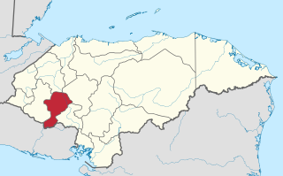
La Paz is the capital city of the La Paz Department of Honduras. The town, founded in 1792, has a population of 30,020.

El Progreso is a city, with a population of 119,260, and a municipality located in the Honduran department of Yoro.
El Corpus is a municipality in the Honduran department of Choluteca.

Talanga is a town, with a population of 19,860, and a municipality in the Honduran department of Francisco Morazán.
Marcala is a town, with a population of 14,360, and a municipality in the Honduran department of La Paz. The region is known for its coffee production, boasting the first "protected origin denomination" for coffee. Marcala has been designated as a center of Lenca Trail, a government and United Nations sponsored development effort to encourage tourism to Lenca communities. It offers visitors perspective on the culture of indigenous people and provides new markets for their traditional crafts.
Santa Ana is a municipality in the Honduran department of La Paz, known for its high crime rate.

La Iguala is a municipality in the Honduran department of Lempira.

Las Flores is a municipality in the Honduran department of Lempira.

Mapulaca is a municipality in the Honduran department of Lempira.
Piraera is one of the municipalities of Lempira department in Honduras. It is located on one of the branches of "Congolón" mountain, it is 105 km away from the city of Gracias.

Virginia is a municipality in the Honduran department of Lempira. Virginia is located in Lempira Honduras and shares a border with El Salvador. Many Virginians travel to El Salvador to do their shopping, because the Honduran cities are far away from Virginia.
El Negrito is a town, with a population of 12,790, and a municipality in the department of Yoro, Honduras.
Morazán is a town, with a population of 19,880, and a municipality in the Honduran department of Yoro. This political division of 47,435 people is in the north, located between the city of Yoro and the municipality of El Negrito, north of the Nico Pijol National Park.
Santa Rita is a town and a municipality in the Honduran department of Yoro. The Humuya River passes through it.
San Marcos is a town, with a population of 6,836, and a municipality in the Honduran department of Ocotepeque.
San José de Colinas is a town, with a population of 5,215, and a municipality in the Honduran department of Santa Bárbara.
Goascorán is a municipality in the Honduran department of Valle.
San Lorenzo is a city, with a population of 33,810, and a municipality in the Honduran department of Valle.

