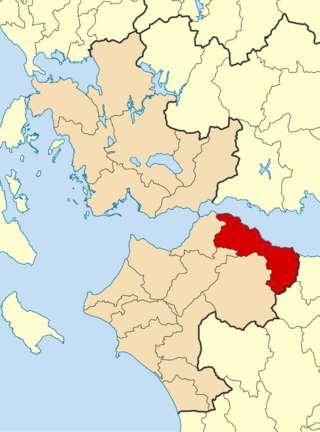
Achaea or Achaia, sometimes transliterated from Greek as Akhaia, is one of the regional units of Greece. It is part of the region of Western Greece and is situated in the northwestern part of the Peloponnese peninsula. The capital is Patras which is the third largest city in Greece.

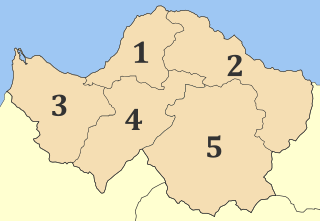
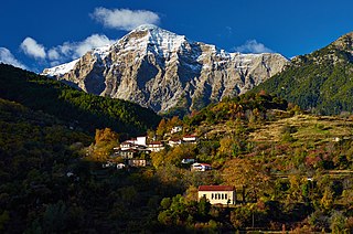
Kalavryta is a town and a municipality in the mountainous east-central part of the regional unit of Achaea, Greece. The town is located on the right bank of the river Vouraikos, 24 kilometres south of Aigio, 40 km southeast of Patras and 62 km northwest of Tripoli. Notable mountains in the municipality are Mount Erymanthos in the west and Aroania or Chelmos in the southeast. Kalavryta is the southern terminus of the Diakopto-Kalavryta rack railway, built by Italian engineers between 1885 and 1895.

Akrata, is a town and a former municipality in Achaea, West Greece, Greece. Since the 2011 local government reform it is part of the municipality Aigialeia, of which it is a municipal unit. The municipal unit has an area of 180.169 km2. Akrata is located on the right bank of the river Krathis, 3 km from its outflow into the Gulf of Corinth. The Greek National Road 8A/E65 and the railway from Patras to Corinth pass through the municipal unit, northeast of the town. The nearest town is Aigeira, 4 km to the east. It is 23 km southeast of Aigio, 52 km east of Patras and 23 km northeast of Kalavryta.

Aroania is a village and a former municipality in Achaea, West Greece, Greece. Since the 2011 local government reform, it is part of the municipality Kalavryta, of which it is a municipal unit. The municipal unit has an area of 173.804 km2. The seat of administration was in the town of Psofida. The municipality is named after the village and the mountain.
Lefkasio is a village and a former municipality in Achaea, West Greece, Greece. The municipality was renamed to Kleitoria in 2008, and in 2011 it became part of the municipality Kalavryta.

Kleitoria is a village and a municipal unit in Achaea, Peloponnese, Greece. It was also the new name of the former municipality Lefkasio, of which it was the seat, between 2008 and 2011. Since the 2011 local government reform it is part of the municipality Kalavryta, and became a municipal unit of this municipality. The municipal unit has an area of 253.221 km2. The site of the ancient city of Cleitor is nearby.

Diakopto is a coastal town in Achaea, West Greece, Greece. Since the 2011 local government reforms it is a municipal unit of the Aigialeia municipality. The municipal unit has an area of 103.932 km2. The town of Diakopto is situated on the Gulf of Corinth, near the mouth of the Vouraikos river and at the lower end of the Vouraikos Gorge. The 750 mm gauge Diakofto–Kalavryta Railway built in 1885 leads up to the town of Kalavryta passing the Mega Spilaio Monastery at about halfway. Diakopto is on the old Greek National Road 8 ; the new Greek National Road 8A passes 1 km to the south. Diakopto is located about 40 km east of Patras, and 15 km southeast of Aigio.

Paia is a former municipality in Achaea, West Greece, Greece. The seat of the municipality was in Dafni. The municipality was created after the Greek War of Independence and was dissolved in 1912. It was recreated in 1998 under the Capodistrian Plan. Since the 2011 local government reform it is part of the municipality Kalavryta, of which it is a municipal unit. The municipal unit has an area of 99.325 km2.
The Kalavryta massacre, or the Holocaust of Kalavryta, was the near-extermination of the male population and the total destruction of the town of Kalavryta, Axis-occupied Greece, by the 117th Jäger Division (Wehrmacht) during World War II, on 13 December 1943.
Ano Vlasia is a mountain village in the municipality of Kalavryta, Achaea, Greece. It is situated at about 900 m elevation. near the source of the river Selinountas, east of the highest summit of Mount Erymanthos. It is 1 km south of Kato Vlasia, 6 km north of Lechouri and 18 km west of Kalavryta.
Kato Vlasia is a mountain village and a community in the municipality of Kalavryta, Achaea, Greece. The community consists of the villages Kato Vlasia, Menychtaiika and Metochi. It is situated at about 800 m elevation. near the source of the river Selinountas, east of the highest summit of Mount Erymanthos. It is 1 km north of Ano Vlasia, 16 km southeast of Chalandritsa and 17 km west of Kalavryta.
Aigialeia is a municipality and a former province (επαρχία) in the eastern part of the Achaea regional unit, Greece. The seat of the municipality is the town Aigio. The municipality has an area of 723.063 km2. The main towns are Aigio, Akrata and Diakopto. The municipality Aigialeia stretches from the south coast of the Gulf of Corinth to the mountainous interior of the Peloponnese peninsula. The main rivers of the municipality are the Selinountas and the Vouraikos.
Kerpini, is a small mountain village in the north of the municipality of Kalavryta in Achaea, Greece. It is 5 km west of Kato Zachlorou and 5 km north of Kalavryta town.
Agia Varvara is a small village and a community in the municipal unit of Akrata, Achaea, Greece. The community includes the village Vounaki. It is built on the forested slopes of Mount Chelmos (Aroania). It is 3 km east of Mesorrougi, 15 km east of Kalavryta and 17 km south of Akrata. Between 1835 and 1912, Agia Varvara constituted a part of the municipality of Nonakrida, and between 1912 and 1996 it was an independent community.
Kertezi is a mountain village in the municipality of Kalavryta, Achaea, Greece. It is built in the valley of a tributary of the river Vouraikos, east of the mountain Kallifoni. It is 12 km southwest of Kalavryta. During the Greek War of Independence, Anagnostis Striftombolas came to Kertezi, took a military body of 15 men and battled in the Battle of Levidi, where he was killed on 14 April 1821.
Mesorrougi is a small village and a community in the municipal unit of Akrata, Achaea, Greece. It is built on the forested slopes of Mount Chelmos (Aroania). The community consists of the villages Mesorrougi, Ano Mesorrougi and Solos. It is 1 km south of Peristera, 12 km east of Kalavryta and 17 km southwest of Akrata. Until 1912, Mesorrougi constituted a part of the municipality of Nonakrida.
Seliana also known as Phelloe is a village in the municipal unit of Aigeira, in the eastern part of Achaea, north Peloponnese, Greece. The village had a population of 57 in 2021. Aigeira is 10 km to the north, and Kalavryta is 21 km to the west. Seliana is connected by a 19 km road that leads to the town of Aegeira and the Greek National Road 8A, Athens - Corinth - Aigeira - Patras.
Kastria is a small village in the Peloponnese peninsula, Greece. It is part of the municipality Kalavryta.
Glastra is a small village in the Peloponnese, Greece. It is part of the municipality of Kalavryta.
Kleitor is a village and community in Achaea, Greece. It is part of the municipality Kalavryta.
