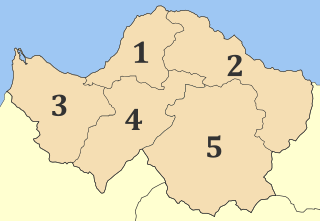
Akrata, is a town and a former municipality in Achaea, West Greece, Greece. Since the 2011 local government reform it is part of the municipality Aigialeia, of which it is a municipal unit. The municipal unit has an area of 180.169 km2. Akrata is located on the right bank of the river Krathis, 3 km from its outflow into the Gulf of Corinth. The Greek National Road 8A/E65 and the railway from Patras to Corinth pass through the municipal unit, northeast of the town. The nearest town is Aigeira, 4 km to the east. It is 23 km southeast of Aigio, 52 km east of Patras and 23 km northeast of Kalavryta.

Aroania is a village and a former municipality in Achaea, West Greece, Greece. Since the 2011 local government reform it is part of the municipality Kalavryta, of which it is a municipal unit. The municipal unit has an area of 173.804 km2. The population is 1,619. The seat of administration was in the town Psofida. The municipality is named after the village and the mountain.

Kato Achaia is a town and a community in Achaea, West Greece, Greece. Since the 2011 local government reform it is part of the municipality West Achaea, of which it is the seat of administration. The community Kato Achaia consists of the town Kato Achaia and the villages Alykes, Manetaiikia, Paralia Kato Achaias and Piso Sykea. Nearby are the ruins of the ancient city of Dyme.

Kleitoria is a village and a municipal unit in Achaea, Peloponnese, Greece. It was also the new name of the former municipality Lefkasio, of which it was the seat, between 2008 and 2011. Since the 2011 local government reform it is part of the municipality Kalavryta, and became a municipal unit of this municipality. The municipal unit has an area of 253.221 km2. The site of the ancient city of Cleitor is nearby.

Paion is a former municipality in Achaea, West Greece, Greece. Its population in 2011 was 1,055. The seat of the municipality was in Dafni. The municipality was created after the Greek War of Independence and was dissolved in 1912. It was recreated in 1998 under the Capodistrian Plan. Since the 2011 local government reform it is part of the municipality Kalavryta, of which it is a municipal unit. The municipal unit has an area of 99.325 km2.

Leontio is a mountain village and a former municipality in Achaea, West Greece, Greece. Since the 2011 local government reform it is part of the municipality Erymanthos, of which it is a municipal unit. The municipal unit has an area of 71.586 km2. It is situated in the southern foothills of the Panachaiko, 13 km east of Chalandritsa, 22 km southeast of Patras, 20 km southwest of Aigio and 19 km northwest of Kalavryta. Its population in 2011 was 246 for the village, 284 for the community and 380 for the municipal unit. The village was renamed for the ancient town of Leontium, the remains of which lie nearby.

Ano Vlasia is a mountain village in the municipality of Kalavryta, Achaea, Greece. It is situated at about 900 m elevation. near the source of the river Selinountas, east of the highest summit of Mount Erymanthos. It is 1 km south of Kato Vlasia, 6 km north of Lechouri and 18 km west of Kalavryta.

Kato Zachlorou is a village and a community in eastern Achaea, Greece. It is built on a mountain slope on the left bank of the river Vouraikos, which forms a narrow gorge. The community consists of the villages Kato Zachlorou and Ano Zachlorou, and the Mega Spilaio monastery. It is 11 km south of Diakopto, and 9 km northeast of Kalavryta. In 2011 Kato Zachlorou had a population of 38 for the village, and 53 for the community. The narrow gauge Diakofto–Kalavryta Railway runs through the village.

Filia is a village in southern Achaea, Greece. Filia is located at the northwestern foot of the hill Mouzakeika (Μουζακεϊκα), at 850 m elevation. It is 1 km south of Lefkasio, 20 km south of Kalavryta, and 45 km northwest of Tripoli. Filia's population in 2011 was 130 for the village, and 211 for the community, which includes the smaller villages Agioi Theodoroi, Kalyvia and Zevgolatio.

Kerpini, is a small mountain village in the north of the municipality of Kalavryta in Achaea, Greece. In 2011 its population was 173. It is 5 km west of Kato Zachlorou and 5 km north of Kalavryta town.

Agia Varvara is a small village in the municipal unit of Akrata, Achaea, Greece. In 2011 its population was 44 for the village and 66 for the community, including the village Vounaki. It is built on the forested slopes of Mount Chelmos (Aroania). It is 3 km east of Mesorrougi, 15 km east of Kalavryta and 17 km south of Akrata. Between 1835 and 1912, Agia Varvara constituted a part of the municipality of Nonakrida.

Mesorrougi is a small village and a community in the municipal unit of Akrata, Achaea, Greece. It is built on the forested slopes of Mount Chelmos (Aroania). The community consists of the villages Mesorrougi, Ano Mesorrougi and Solos. It is 1 km south of Peristera, 12 km east of Kalavryta and 17 km southwest of Akrata. Until 1912, Mesorrougi constituted a part of the municipality of Nonakrida.

Agrampela is a village in the municipal unit of Aroania, Achaea, Greece. In 2011, it had a population of 41 for the village and 99 for the community, which includes the village Platanitsa. It is situated in the southern foothills of the Mount Erymanthos. It is 2 km northwest of Plaka, 8 km east of Kalentzi and 26 km southwest of Kalavryta.

Kamenianoi is a mountain village and a community in the municipal unit of Aroania, Achaea, Greece. In 2011 the population was 85 for the village, and 116 for the community, which includes the village Drovolovo. It is situated in the eastern foothills of Mount Erymanthos. Kamenianoi is 2 km west of Desino, 4 km southeast of Lechouri and 17 km southwest of Kalavryta.

Lechouri is a mountain village and a community in the municipal unit of Aroania, Achaea, Greece. In 2011, it had a population of 209 for the village and 288 for the community, which includes the villages Kerasia and Selli. The village is situated at about 1,000 m above sea level, near the mountain Kallifoni, which is part of the Erymanthos range. It is 4 km northeast of Livartzi, 6 km south of Ano Vlasia, 4 km northwest of Kamenianoi and 18 km southwest of Kalavryta.

Psofida is a village and a community in the municipal unit of Aroania in the southern part of Achaea, Greece. The community consists of the villages Psofida, Ano Psofida, Tripotama, Ano Tripotama, Kato Tripotama and Vasiliki. Psofida was named after the ancient Arcadian town Psophis, that was located near the present village Tripotama. It is situated near the confluence of the rivers Erymanthos, Aroanios and Seiraios, and near the tripoint of Achaea, Arcadia and Elis. It is 4 km southwest of Livartzi, 9 km east of Lampeia, 25 km southwest of Kalavryta and 45 km southeast of Patras. The Greek National Road 33 passes through Tripotama.
The Selinountas is a river in Achaea, Greece. It is 47.8 km (29.7 mi) long. Its source is on Mount Erymanthos, near the village Kato Vlasia in southern Achaea. It flows in generally northeastern direction, through the municipalities Kalavryta and Aigialeia. It flows into the Gulf of Corinth in the village Valimitika, near the town Aigio.


