Trikolonoi is a former municipality in Arcadia, Peloponnese, Greece. Since the 2011 local government reform it is part of the municipality Gortynia, of which it is a municipal unit. The municipal unit has an area of 102.031 km2. The municipal unit includes the villages of Stemnitsa, Syrna, Pavlia, Palamari, Psari, Ano Kalyvia and Elliniko. Trikolonoi is located southeast of Dimitsana, west of Tripoli and north of Megalopoli. The place takes its name from the ancient town of Tricoloni.

Astakos is a town and a former municipality in Aetolia-Acarnania, West Greece, Greece. Since the 2011 local government reform it is part of the municipality Xiromero, of which it is a municipal unit. The municipal unit has an area of 345.099 km2. It is located on a bay on the eastern shore of the Ionian Sea, near the southern end of the Acarnanian Mountains. It takes its name from the ancient Acarnanian town Astacus, and was named Dragamesti in the Middle Ages. It is speculated to be the site of ancient Dulichium.

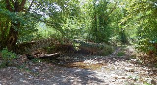
Kalavryta is a town and a municipality in the mountainous east-central part of the regional unit of Achaea, Greece. The town is located on the right bank of the river Vouraikos, 24 kilometres south of Aigio, 40 km southeast of Patras and 62 km northwest of Tripoli. Notable mountains in the municipality are Mount Erymanthos in the west and Aroania or Chelmos in the southeast. Kalavryta is the southern terminus of the Diakopto-Kalavryta rack railway, built by Italian engineers between 1885 and 1895.

Akrata, is a town and a former municipality in Achaea, West Greece, Greece. Since the 2011 local government reform it is part of the municipality Aigialeia, of which it is a municipal unit. The municipal unit has an area of 180.169 km2. Akrata is located on the right bank of the river Krathis, 3 km from its outflow into the Gulf of Corinth. The Greek National Road 8A/E65 and the railway from Patras to Corinth pass through the municipal unit, northeast of the town. The nearest town is Aigeira, 4 km to the east. It is 23 km southeast of Aigio, 52 km east of Patras and 23 km northeast of Kalavryta.

Falaisia is a village and a former municipality in southwestern Arcadia, Peloponnese, Greece. Since the 2011 local government reform it is part of the municipality Megalopoli, of which it is a municipal unit. The municipal unit has an area of 274.926 km2. The seat of the municipality was in Leontari, 5 km northwest of the village Falaisia. The municipal unit Falaisia is located in the northern foothills of the Taygetus mountains, south of Megalopoli and north of Kalamata. It borders on Laconia to the southeast, and Messenia to the southwest.
Louros is a town and a former municipality in the Preveza regional unit, Epirus, Greece. It was the center of a kaza of the Preveza Sanjak under the Ottoman Empire. Since the 2011 local government reform it is part of the municipality Preveza, of which it is a municipal unit. The seat of the municipality was the small town of Louros. The area of the municipal unit is 176.075 km2, with a population of 4,581 people (2011). The town and municipal unit are named after the river Louros which flows just south of the town. Until recently, the Louros valley was swampy, but in modern times the marshes were drained and are now used for the production of olives, oranges, lemons and tomatoes. Besides the town of Louros itself, the largest communities in the municipality are Oropós, Stefáni (379), Vrysoúla (149), Áno Ráchi (96), and Kotsanópoulo (200).
Apodotia is a former municipality in Aetolia-Acarnania, West Greece, Greece. Since the 2011 local government reform it is part of the municipality Nafpaktia, of which it is a municipal unit. The municipal unit has an area of 257.635 km2. The seat of the municipality, established in 1996, was the village Ano Chora. An earlier municipality Apodotia existed between 1835 and 1912.

Chalkeia is a former municipality in Aetolia-Acarnania, West Greece, Greece. Since the 2011 local government reform it is part of the municipality Nafpaktia, of which it is a municipal unit. The municipal unit has an area of 114.189 km2. Population 2,219 (2021). The seat of the municipality was in Trikorfo.
Agios Kosmas is a village, a community and a municipal unit of the Grevena municipality. Before the 2011 local government reform it was an independent municipality. The municipality was established in 1997 with the name Kosmas o Aitolos, which was changed to Agios Kosmas in 2004. The seat of the municipality was in Megaro. The 2021 census recorded 54 residents in the community and 681 residents in the municipal unit. The community of Agios Kosmas covers an area of 9.496 km2 while the municipal unit covers an area of 115.087 km2. The village is named after the 18th-century saint Cosmas the Aetolian.
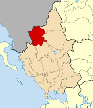
Agrampela is a village and a community in the municipal unit of Aroania, Achaea, Greece. The community includes the village Platanitsa. It is situated in the southern foothills of the Mount Erymanthos. It is 2 km northwest of Plaka, 8 km east of Kalentzi and 26 km southwest of Kalavryta.
Desino is a mountain village in the municipal unit of Aroania, Achaea, Greece. The village is situated in the eastern foothills of Mount Erymanthos. The name is a corruption of the word στενό "narrow". Desino is 2 km east of Kamenianoi, 4 km west of Priolithos and 15 km southwest of Kalavryta.

Kamenianoi is a mountain village and a community in the municipal unit of Aroania, Achaea, Greece. The community includes the village Drovolovo. It is situated in the eastern foothills of Mount Erymanthos. Kamenianoi is 2 km west of Desino, 4 km southeast of Lechouri and 17 km southwest of Kalavryta.
Lechouri is a mountain village and a community in the municipal unit of Aroania, Achaea, Greece. The community includes the villages Kerasia and Selli. The village is situated at about 900 m above sea level, near the mountain Kallifoni, which is part of the Erymanthos range. It is 4 km northeast of Livartzi, 6 km south of Ano Vlasia, 4 km northwest of Kamenianoi and 18 km southwest of Kalavryta.
Plaka is a village in the municipal unit of Aroania, Achaea, Greece. It is situated in the southern foothills of Mount Erymanthos. It is 2 km southeast of Agrampela, 4 km west of Livartzi and 25 km southwest of Kalavryta.
Seires is a mountain village and a community in the municipal unit of Aroania, Achaea, Greece. It was named after the ancient town Seirae, that was part of Arcadian Azania. The community includes the villages Agioi Theodoroi, Agios Georgios, Krini and Thomaiika. Seires is situated at 940 m above sea level. Seires is 3 km west of Alestaina, 4 km northwest of Paos, 5 km east of Psofida and 23 km southwest of Kalavryta.

Psofida is a village and a community in the municipal unit of Aroania in the southern part of Achaea, Greece. The community consists of the villages Psofida, Ano Psofida, Tripotama, Ano Tripotama, Kato Tripotama and Vasiliki. Psofida was named after the ancient Arcadian town Psophis, that was located near the present village Tripotama. It is situated near the confluence of the rivers Erymanthos, Aroanios and Seiraios, and near the tripoint of Achaea, Arcadia and Elis. It is 4 km southwest of Livartzi, 9 km east of Lampeia, 25 km southwest of Kalavryta and 45 km southeast of Patras. The Greek National Road 33 passes through Tripotama.
Pogoni is a municipality in the Ioannina regional unit, Epirus, Greece. The seat of the municipality is the village Kalpaki. The municipality has an area of 701.059 km2. Its population was 6,848 at the 2021 census.

Voio is a municipality in the Kozani regional unit, Greece. The seat of the municipality is the town Siatista. It was named after the Voio mountains. The municipality has an area of 1007.629 km2. Its population at the 2021 census was 14,947.
Ano Stavros is a village and a community of the Volvi municipality. Before the 2011 local government reform it was part of the municipality of Egnatia, of which it was a municipal district. The 2021 census recorded 768 inhabitants in the village. The community of Ano Stavros covers an area of 19.50 km2.
Agrampela is an Aromanian (Vlach) village and a community of the Xiromero municipality. Since the 2011 local government reform it was part of the municipality Astakos, of which it was a municipal district. The 2021 census recorded 58 residents in the village. The community of Agrampela covers an area of 8.726 km2.

