
Long Valley Caldera is a depression in eastern California that is adjacent to Mammoth Mountain. The valley is one of the Earth's largest calderas, measuring about 20 mi (32 km) long (east-west), 11 mi (18 km) wide (north-south), and up to 3,000 ft (910 m) deep.

A fumarole is a vent in the surface of the Earth or other rocky planets from which hot volcanic gases and vapors are emitted, without any accompanying liquids or solids. Fumaroles are characteristic of the late stages of volcanic activity, but fumarole activity can also precede a volcanic eruption and has been used for eruption prediction. Most fumaroles die down within a few days or weeks of the end of an eruption, but a few are persistent, lasting for decades or longer. An area containing fumaroles is known as a fumarole field.

Geothermal energy is thermal energy in the Earth's crust. It combines energy from the formation of the planet and from radioactive decay. Geothermal energy has been exploited as a source of heat and/or electric power for millennia.

The geothermal areas of Yellowstone include several geyser basins in Yellowstone National Park as well as other geothermal features such as hot springs, mud pots, and fumaroles. The number of thermal features in Yellowstone is estimated at 10,000. A study that was completed in 2011 found that a total of 1,283 geysers have erupted in Yellowstone, 465 of which are active during an average year. These are distributed among nine geyser basins, with a few geysers found in smaller thermal areas throughout the Park. The number of geysers in each geyser basin are as follows: Upper Geyser Basin (410), Midway Geyser Basin (59), Lower Geyser Basin (283), Norris Geyser Basin (193), West Thumb Geyser Basin (84), Gibbon Geyser Basin (24), Lone Star Geyser Basin (21), Shoshone Geyser Basin (107), Heart Lake Geyser Basin (69), other areas (33). Although famous large geysers like Old Faithful are part of the total, most of Yellowstone's geysers are small, erupting to only a foot or two. The hydrothermal system that supplies the geysers with hot water sits within an ancient active caldera. Many of the thermal features in Yellowstone build up sinter, geyserite, or travertine deposits around and within them.

Whakaari / White Island, also known as White Island or Whakaari, is an active andesite stratovolcano situated 48 km (30 mi) from the east coast of the North Island of New Zealand, in the Bay of Plenty. The island covers an area of approximately 325 ha, which is just the peak of a much larger submarine volcano.

Geothermal heating is the direct use of geothermal energy for some heating applications. Humans have taken advantage of geothermal heat this way since the Paleolithic era. Approximately seventy countries made direct use of a total of 270 PJ of geothermal heating in 2004. As of 2007, 28 GW of geothermal heating capacity is installed around the world, satisfying 0.07% of global primary energy consumption. Thermal efficiency is high since no energy conversion is needed, but capacity factors tend to be low since the heat is mostly needed in the winter.

Geothermal power in Australia was at one time hoped to provide cost effect, renewable power for Australia. There are locations that have been shown to contain hot granites at depth which hold good potential for development of geothermal energy. Exploratory geothermal wells have been drilled to test for the presence of high temperature geothermal reservoir rocks and such hot granites were detected. However, all these projects have since been abandoned. A small geothermal plant in Queensland experienced problems during commissioning and as at May 2022, remains idle.

Geothermal power is electrical power generated from geothermal energy. Technologies in use include dry steam power stations, flash steam power stations and binary cycle power stations. Geothermal electricity generation is currently used in 26 countries, while geothermal heating is in use in 70 countries.

Geothermal power in New Zealand is a small but significant part of the energy generation capacity of the country, providing approximately 17% of the country's electricity with installed capacity of over 900MW. New Zealand, like only a small number of other countries worldwide, has numerous geothermal sites that could be developed for exploitation, and also boasts some of the earliest large-scale use of geothermal energy in the world.
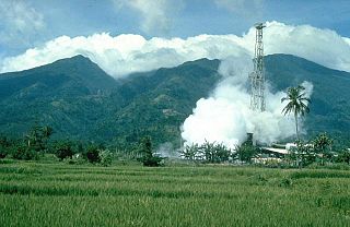
Mount Malinao is a potentially active stratovolcano located in the Bicol Region of the Philippines. The volcano displays strong fumarolic activity which is harnessed for generating electricity. Located on its slope is Tiwi Geothermal Power Plant, one of the first geothermal energy plant commissioned in the country.

Puyehue and Cordón Caulle are two coalesced volcanic edifices that form a major mountain massif in Puyehue National Park in the Andes of Ranco Province, in the South of Chile. In volcanology this group is known as the Puyehue-Cordón Caulle Volcanic Complex (PCCVC). Four volcanoes constitute the volcanic group or complex, the Cordillera Nevada caldera, the Pliocene Mencheca volcano, Cordón Caulle fissure vents and the Puyehue stratovolcano.
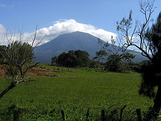
Rincón de la Vieja is an active andesitic complex volcano in north-western Costa Rica, about 23 km (14 mi) from Liberia, in the province of Guanacaste.
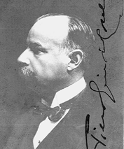
Piero Ginori Conti, Prince of Trevignano, was a businessman and Italian politician.
Italy's total electricity consumption was 302.75 terawatt-hour (TWh) in 2020, of which 270.55 TWh (89.3%) was produced domestically and the remaining 10.7% was imported.
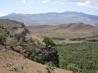
Ol Doinyo Eburru is an active complex of volcanoes in the Great Rift Valley, Kenya to the northwest of Lake Naivasha. It is being exploited for geothermal energy. Soysambu Conservancy is located to the north of the massif, between Lake Elmenteita to the east and Lake Nakuru to the west.

Geothermal power accounts for about 1.6-1.8% of the total electric energy production in Italy and is about 7% of the total renewable energy produced in 2010. The total energy from Geothermal was 5,660 GWh in 2015. Italy is the seventh country by geothermal installed capacity.

The Olkaria Area is a region located immediately to the south of Lake Naivasha in the Great Rift Valley of Kenya, Africa. It is geothermally active and is being used to generate clean electric power. The region has an estimated potential of 2,000 MW. This is almost double the maximum daily electricity peak demand recorded in 2008/2009 for the entire country.
Events from the year 1904 in Italy.

Apacheta-Aguilucho volcanic complex is a volcanic complex in Chile. It consists of two volcanoes Cerro Apacheta and Cerro Aguilucho, which are constructed mainly by lava flows and surrounded by outcrops of lava. A sector collapse and its landslide deposit are located on Apacheta's eastern flank. Two lava domes are associated with the volcanic complex, Chac-Inca and Pabellón.
The Salton Buttes are a group of volcanoes in California, on the Salton Sea. They consist of a 7-kilometer (4.3 mi)-long row of five lava domes, named Mullet Island, North Red Hill, Obsidian Butte, Rock Hill and South Red Hill. They are closely associated with a fumarolic field and a geothermal field, and there is evidence of buried volcanoes underground. In pre-modern times Obsidian Butte was an important regional source of obsidian.


