Las Flores, Honduras

Last updated
Las Flores
Municipality
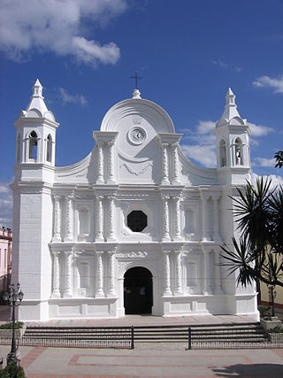
La Flores,Lempira 5.JPG
Main entrance with Puca mountain on the back
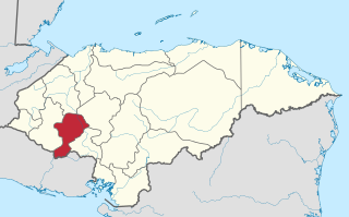
Honduras location map.svg
Red pog.svg
Las Flores
Location in Honduras
Coordinates: 14°42′N88°36′W / 14.700°N 88.600°W / 14.700; -88.600
CountryHonduras
DepartmentLempira
Municipality since1 January 1869;155 years ago (1869-01-01)
Area
  Total78 km2 (30 sq mi)
Population
 (2015)
  Total9,838
  Density130/km2 (330/sq mi)

Las Flores is a municipality in the Honduran department of Lempira.

Contents

Las Flores is one of the municipalities of the Lempira department. It is located 17 kilometres (11 miles) from Gracias on the paved road that leads to Santa Rosa de Copán. The town is 200 metres (660 feet) away from the paved road.

History

The very first settlers were from La Paz department. It was first called "Las Flores de Santa Bárbara", honoring the image of the saint of that place. It was granted the category of municipality on 1 January 1869.[ citation needed ]

Geography

This municipality is in a valley, near to a river. The vegetation corresponds to dry sub-tropical forests. The weather is hot since it is in a valley. There are some hills around it but they are not so high or steep.[ citation needed ]

Boundaries

Its boundaries are:

The Local Mayor's Office La Flores,Lempira 2.JPG
The Local Mayor's Office

Resources

The most important economical activity is commerce due to its location near to Gracias city and Santa Rosa de Copán city. On both sides of the road are several restaurants, stores, and car workshops. Cattle and Milk products are for local consumption. Another popular activity is to collect gravel, sand and construction materials from the two nearby rivers. Most of this material is required by Gracias city. Recently, the material has been used in the highway extension between Gracias, Lempira, and La Esperanza, Intibucá. Most of the people that live in the town only make their school in there. After that most of the people move to the nearest city, Santa Rosa de Copan, where education is more efficient. Because of the peace that the inhabitants experience it is very normal for them to gather at the central park or on streets very late at night.

Population

In this case 90% of the people are cross-breed of native Indians and Spanish settlers.

Demographics

At the time of the 2013 Honduras census, Las Flores municipality had a population of 9,512. Of these, 97.43% were Mestizo, 1.45% White, 0.83% Indigenous, 0.27% Black or Afro-Honduran and 0.01% others. [1]

Tourism

A 1 hour visit to the downtown of Las Flores will do to get to know it. There are several places to go swimming because of the rivers. There are a couple of places with internet access.

Panoramic view of town La Flores,Lempira 3.JPG
Panoramic view of town

Related Research Articles

<span class="mw-page-title-main">Departments of Honduras</span> First-level administrative division of Honduras

Honduras is divided into 18 departments. Each department is headed by a governor, who is appointed by the President of Honduras. The governor represents the executive branch in the region in addition to acting as intermediary between municipalities and various national authorities; resolves issues arising between municipalities; oversees the penitentiaries and prisons in his department; and regularly works with the various Secretaries of State that form the President's Cabinet. To be eligible for appointment as a governor, the individual must: a) live for five consecutive years in the department; b) be Honduran; c) be older than 18 years of age and; d) know how to read and write.
<span class="mw-page-title-main">Copán Department</span> Department in Honduras

Copán is one of the departments in the western part of Honduras. The departmental capital is the town of Santa Rosa de Copán. The department is well known for its tobacco and fine cigars.
<span class="mw-page-title-main">Intibucá Department</span> Department in Honduras

Intibucá is one of the 18 departments in the Republic of Honduras. Intibucá covers a total surface area of 1,186.1 square miles (3,072 km2). Its capital is the city of La Esperanza, in the municipality of La Esperanza.

<span class="mw-page-title-main">Lempira Department</span> Department in Honduras

Lempira is one of the 18 departments in Honduras. located in the western part of the country, it is bordered by the departments of Ocotepeque and Copán to the west, Intibucá to the east, and Santa Bárbara to the north. To its south lies the El Salvador–Honduras border. The departmental capital is Gracias.

<span class="mw-page-title-main">Santa Rosa de Copán</span> Municipality in Copán, Honduras

Santa Rosa de Copán is a municipality in Honduras. The city of Santa Rosa de Copán is the municipal seat and the departmental capital of the Honduran department of Copán. It is located approximately 1,150 metres (3,773 ft) above mean sea level.
<span class="mw-page-title-main">Gracias</span> Municipality in Lempira, Honduras

Gracias is a small Honduran town/municipality that was founded in 1536, and is the capital of Lempira Department.

La Esperanza is the capital city and a municipality of the same name of the department of Intibucá, Honduras. La Esperanza is famous for having the coolest climate in Honduras. It is considered the heart of the Ruta Lenca, a region of Lenca ethnic influence that spans Honduras from Santa Rosa de Copan to Choluteca. Sites on the Lenca Trail have been designated by the government and United Nations development in order to encourage more cultural tourism, and help create new markets for the traditional crafts, such as pottery, practiced by the Lenca, in order to preserve their culture.

<span class="mw-page-title-main">Guarita</span> Municipality in Lempira, Honduras

Guarita is a municipality in the Honduran department of Lempira.

<span class="mw-page-title-main">La Iguala</span> Municipality in Lempira, Honduras

La Iguala is a municipality in the Honduran department of Lempira.
<span class="mw-page-title-main">La Unión, Lempira</span> Municipality in Lempira, Honduras

La Unión is a municipality in the Honduran department of Lempira.
<span class="mw-page-title-main">La Virtud</span> Municipality in Lempira, Honduras

La Virtud is a municipality in the Honduran department of Lempira.

<span class="mw-page-title-main">Lepaera</span> Municipality in Lempira, Honduras

Lepaera is a municipality in the Honduran department of Lempira. It has tropical climate all year round.

<span class="mw-page-title-main">Mapulaca</span> Municipality in Lempira, Honduras

Mapulaca is a municipality in the Honduran department of Lempira.
<span class="mw-page-title-main">San Rafael, Honduras</span> Municipality in Honduras

San Rafael is a municipality in the Honduran department of Lempira.

<span class="mw-page-title-main">Talgua</span> Municipality in Lempira, Honduras

Talgua is a municipality in the Honduran department of Lempira.
<span class="mw-page-title-main">Tambla</span> Municipality in Lempira, Honduras

Tambla is a municipality in the Honduran department of Lempira.

<span class="mw-page-title-main">Tomalá</span> Municipality in Lempira, Honduras

Tomalá is a municipality in the Honduran department of Lempira.

<span class="mw-page-title-main">Belén, Honduras</span> Municipality in Lempira, Honduras

Belén is a municipality in the Honduran department of Lempira. The latitude is 15.75 north, the longitude is 87.93 west, and the altitude is 313 meters.

<span class="mw-page-title-main">Honduran folklore</span>

Honduras has rich folk traditions that derive from the fusion of four different cultural groups: indigenous, European, African and Creole. Each department or region, municipality, village and even hamlet contributes its own traditions including costumes, music, beliefs, stories, and all the elements that derive from and are transformed by peoples in a population. In sum, these define Honduran Folklore as expressed by crafts, tales, legends, music and dances.

<span class="mw-page-title-main">San Cristóbal fortress (Honduras)</span>

The San Cristóbal fortress is located in the city of Gracias, department of Lempira, built on a small hill above the city, which was formerly the center of the town of Gracias Lempira, which was once the capital of New Spain and headquarters of the Real Audiencia de los Confines in 1544; Gracias was a strategic city within the Province of Honduras in the colonial era, then in the pro-independence era and then in the Central American federal transition.

References

14°42′N88°37′W / 14.700°N 88.617°W / 14.700; -88.617