San Francisco, Lempira

Last updated

San Francisco
Municipality
San Francisco,Lempira.JPG
Panoramic View of San Francisco
Honduras location map.svg
Red pog.svg
San Francisco
Location in Honduras
Coordinates: 14°7′N88°22′W / 14.117°N 88.367°W / 14.117; -88.367
CountryHonduras
DepartmentLempira
Founded1837
Area
  Total133 km2 (51 sq mi)
Population
  Total9,146
  Density69/km2 (180/sq mi)
 2015

San Francisco is a municipality in the Honduran department of Lempira.

Contents

It is one of the furthest municipalities of the Lempira department in Honduras.

History

The lands for this municipality were given away by the King of Spain, on 30 October 1692, composed of 2 titles, "Santa Maria Magdalena" and "San Lucas". In the census of 1791 it appears as part of "Curato de Cerquin". It was founded in 1837 for the initiative of Captain Jeronimo Acosta. The church was built in 1856, a historical relic left by the Spanish colonist. But as it can be seen in the photo in this article, the date on the church is 1737. Something worth verifying. In the national division of 1896, it was one of the municipalities of Erandique district.

The Ancient Colonial Church San Francisco,Lempira 5.JPG
The Ancient Colonial Church

Geography

The municipality capital is located at the toe of "Gelpoa" hill. To get to this capital it is necessary to go up and down mountains and hills, mostly going down, while doing this, the elevation from sea level decreases, this is why the vegetation is typical of dry sub tropical forests. The weather is warm most of the year. In some uninhabited places there are pine forests.

Boundaries

Its boundaries are:

Resources

The main products of this municipality are corn and beans. There are very few areas suitable for coffee plantations. The water for human consumption is obtained for excavated wells and some small streams nearby. Cattle and milk products are for local consumption. As does the rest of the department, it has electricity, mobile communication services and internet access at the mayor's office. Groceries stores are quite plentiful. In some houses, people sell gasoline and diesel fuel.

Arriving in town San Francisco,Lempira 2.JPG
Arriving in town

Population

It is very common to see people who are descendants of the Indians, followed by a few individuals of cross-breed of Spanish and Indians.

Demographics

At the time of the 2013 Honduras census, San Francisco municipality had a population of 9,017. Of these, 91.76% were Indigenous, 7.53% Mestizo, 0.69% Black or Afro-Honduran and 0.02% White. [1]

Tourism

Both ways to get there require a great deal of endurance and patience. If the visitor is in Gracias, then he must go to San Juan del Caite, Intibuca for the junction of the road the "San Miguelito, Intibuca" or Erandique. If the visitor is in "La Esperanza, Intibuca", then they must go to "San Miguelito" and after that to "Dolores,Intibuca". There is another junction of the road from Erandique and Dolores, Intibuca in a community called "San Antonio". This road is in bad shape half of the year, so caution is advised. It has little to offer to the visitors. Perhaps the antique church is the best attraction. But that is not a problem at all; because there is a DVD store, where the visitor can find the newest Hollywood premieres, on the other hand, the nearest place to fix a flat tire is 30 km away in Erandique. The people are very welcoming and kind to the foreigners.

Related Research Articles

<span class="mw-page-title-main">Intibucá Department</span> Department in Honduras

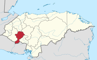
Intibucá is one of the 18 departments in the Republic of Honduras. Intibucá covers a total surface area of 1,186.1 square miles (3,072 km2). Its capital is the city of La Esperanza, in the municipality of La Esperanza.

<span class="mw-page-title-main">Lempira Department</span> Department in Honduras

Lempira is one of the 18 departments in Honduras. located in the western part of the country, it is bordered by the departments of Ocotepeque and Copán to the west, Intibucá to the east, and Santa Bárbara to the north. To its south lies the El Salvador–Honduras border. The departmental capital is Gracias.

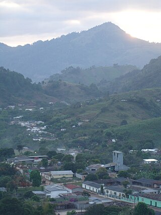
La Esperanza is the capital city and a municipality of the same name of the department of Intibucá, Honduras. La Esperanza is famous for having the coolest climate in Honduras. It is considered the heart of the Ruta Lenca, a region of Lenca ethnic influence that spans Honduras from Santa Rosa de Copan to Choluteca. Sites on the Lenca Trail have been designated by the government and United Nations development in order to encourage more cultural tourism, and help create new markets for the traditional crafts, such as pottery, practiced by the Lenca, in order to preserve their culture.

Concepción is a municipality in the Honduran department of Intibucá.

San Miguel Guancapla is a municipality in the Honduran department of Intibucá.

<span class="mw-page-title-main">Candelaria, Lempira</span> Municipality in Lempira, Honduras

Candelaria is a municipality in the Honduran department of Lempira.

<span class="mw-page-title-main">Erandique</span> Municipality in Lempira, Honduras

Erandique is a municipality in the Lempira Department of Honduras.

<span class="mw-page-title-main">Gualcince</span> Municipality in Lempira, Honduras

Gualcince is a municipality in the Honduran department of Lempira.

<span class="mw-page-title-main">La Iguala</span> Municipality in Lempira, Honduras

La Iguala is a municipality in the Honduran department of Lempira.

<span class="mw-page-title-main">Las Flores, Lempira</span> Municipality in Lempira, Honduras

Las Flores is a municipality in the Honduran department of Lempira.

<span class="mw-page-title-main">La Unión, Lempira</span> Municipality in Lempira, Honduras

La Unión is a municipality in the Honduran department of Lempira.

<span class="mw-page-title-main">Piraera</span> Municipality in Lempira, Honduras

Piraera is one of the municipalities of Lempira department in Honduras. It is located on one of the branches of "Congolón" mountain, it is 105 km away from the city of Gracias.

<span class="mw-page-title-main">San Andrés, Lempira</span> Municipality in Lempira, Honduras

San Andrés is a municipality in the Honduran department of Lempira.

<span class="mw-page-title-main">San Juan Guarita</span> Municipality in Lempira, Honduras

San Juan Guarita is a municipality in the Honduran department of Lempira.

<span class="mw-page-title-main">Santa Cruz, Lempira</span> Municipality in Lempira, Honduras

Santa Cruz is a municipality in the Honduran department of Lempira.

<span class="mw-page-title-main">Tomalá</span> Municipality in Lempira, Honduras

Tomalá is a municipality in the Honduran department of Lempira.

<span class="mw-page-title-main">Belén, Honduras</span> Municipality in Lempira, Honduras

Belén is a municipality in the Honduran department of Lempira. The latitude is 15.75 north, the longitude is 87.93 west, and the altitude is 313 meters.

Honducor is the mail service of Honduras.

Honduras has rich folk traditions that derive from the fusion of four different cultural groups: indigenous, European, African and Creole. Each department or region, municipality, village and even hamlet contributes its own traditions including costumes, music, beliefs, stories, and all the elements that derive from and are transformed by peoples in a population. In sum, these define Honduran Folklore as expressed by crafts, tales, legends, music and dances.

Intibucá is a city, with a population of 25,570, and a municipality in the department of Intibucá, Honduras. The urban area of Intibucá is an important transit and commercial site in the South-West region of Honduras. Located 1,850 meters above sea level, Intibucá has a cool and often foggy climate, hence the nickname "La ciudad del manto blanco". Potato production, celebrated by the annual Festival de la Papa, is the principal basis of the economy for the municipality.

References

Coordinates: 14°7′N88°22′W / 14.117°N 88.367°W / 14.117; -88.367