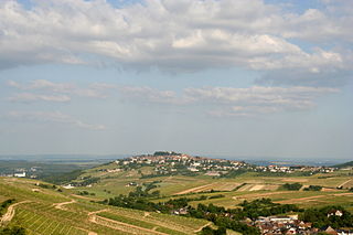
Sancerre is a medieval hilltop town (ville) and commune in the Cher department, France overlooking the river Loire. It is noted for its wine.

Coppenbrügge is a municipality in the Hamelin-Pyrmont district, in Lower Saxony, Germany. It is situated approximatively 15 km east of Hamelin.

Poggio Sannita is a comune (municipality) in the Province of Isernia in the Italian region Molise, located about 30 kilometres (19 mi) northwest of Campobasso and about 25 kilometres (16 mi) northeast of Isernia. Poggio Sannita is on a promontory surrounded by the Verrino and Sente rivers, both mostly torrential in character, especially the latter, which dries up completely during the summer.

Gössenheim is a community in the Main-Spessart district in the Regierungsbezirk of Lower Franconia (Unterfranken) in Bavaria, Germany and a member of the Verwaltungsgemeinschaft of Gemünden am Main.

Becherbach bei Kirn is an Ortsgemeinde – a municipality belonging to a Verbandsgemeinde, a kind of collective municipality – in the Bad Kreuznach district in Rhineland-Palatinate, Germany. It belongs to the Verbandsgemeinde Kirner Land, whose seat is in the town of Kirn. Becherbach bei Kirn should not be confused with Becherbach. Becherbach bei Kirn has borne the tag “bei Kirn” since 1 July 1969, at which time both municipalities found themselves in the same district as a result of administrative reform.

Jossgrund is a municipality in the Main-Kinzig district, in Hesse, Germany. It has around 3,500 inhabitants distributed among several formerly independent villages, now Ortsteile. The administration seat is at Oberndorf.

Aschbach is an Ortsgemeinde – a municipality belonging to a Verbandsgemeinde, a kind of collective municipality – in the Kusel district in Rhineland-Palatinate, Germany. It belongs to the Verbandsgemeinde Lauterecken-Wolfstein.

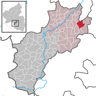
Börsborn is an Ortsgemeinde – a municipality belonging to a Verbandsgemeinde, a kind of collective municipality – in the Kusel district in Rhineland-Palatinate, Germany. It belongs to the Verbandsgemeinde of Oberes Glantal.

Dittweiler is an Ortsgemeinde – a municipality belonging to a Verbandsgemeinde, a kind of collective municipality – in the Kusel district in Rhineland-Palatinate, Germany. It belongs to the Verbandsgemeinde of Oberes Glantal, whose seat is in Schönenberg-Kübelberg.

Gries is an Ortsgemeinde – a municipality belonging to a Verbandsgemeinde, a kind of collective municipality – in the Kusel district in Rhineland-Palatinate, Germany. It belongs to the Verbandsgemeinde of Oberes Glantal, whose seat is in Schönenberg-Kübelberg.
Hinzweiler is an Ortsgemeinde – a municipality belonging to a Verbandsgemeinde, a kind of collective municipality – in the Kusel district in Rhineland-Palatinate, Germany. It belongs to the Verbandsgemeinde Lauterecken-Wolfstein.

Nerzweiler is an Ortsgemeinde – a municipality belonging to a Verbandsgemeinde, a kind of collective municipality – in the Kusel district in Rhineland-Palatinate, Germany. It belongs to the Verbandsgemeinde Lauterecken-Wolfstein.
Oberweiler im Tal is an Ortsgemeinde – a municipality belonging to a Verbandsgemeinde, a kind of collective municipality – in the Kusel district in Rhineland-Palatinate, Germany. It belongs to the Verbandsgemeinde Lauterecken-Wolfstein.
Quirnbach/Pfalz is an Ortsgemeinde – a municipality belonging to a Verbandsgemeinde, a kind of collective municipality – in the Kusel district in Rhineland-Palatinate, Germany. It belongs to the Verbandsgemeinde Oberes Glantal.
Reipoltskirchen is an Ortsgemeinde – a municipality belonging to a Verbandsgemeinde, a kind of collective municipality – in the Kusel district in Rhineland-Palatinate, Germany. It belongs to the Verbandsgemeinde Lauterecken-Wolfstein.

Berwartstein Castle is a castle in the Wasgau, the southern part of the Palatinate Forest in the state Rhineland-Palatinate in southwestern Germany. It was one of the rock castles that were part of defences of the Palatinate during the Middle Ages. This castle is noted in the publication Works of Preservation of Monuments of Rheinland-Pfalz, which was assembled and edited for the Ministry of Education and Culture. This states that the three prime examples of rock castles in the region are Drachenfels, Altdahn and Berwartstein, castles where the stairs, passages and rooms are carved out of the rock to form part of the accommodation essential to the defence of the castle. Although the Berwartstein appears more complete when compared to the ruins of neighbouring castles, it is only a restoration of the original rock castle. It is the only castle in the Palatinate that was rebuilt and re-inhabited after its demolition.

The Calenberg Land is a historic landscape southwest of Hanover in Germany, roughly formed by the countryside between the Leine and the Deister hills. The name of this region comes from the Principality of Calenberg ruled the area during the Middle Ages with its seat at Calenberg Castle near Pattensen.
Saldern or von Saldern, is the name of an old German aristocratic family from the areas of Hildesheim and Brunswick Land. The family seat of the same name is an eponymous castle on the River Fuhse in Salzgitter-Salder. Originally the family, whose branches are still alive today, only owned estates in the Lower Saxony area, but from the middle of the 16th century they also owned extensive property in the March of Brandenburg.

Lauenstein Castle is a former hill castle that is now in ruins. It lies above the Salzhemmendorf village of Lauenstein in the German state of Lower Saxony. The castle was built in the 13th century by the barons of Homburg. From the 16th century it became militarily insignificant and was demolished in the 19th century due to its increasing state of dilapidation.
Lüthorst is a village in Lower Saxony. It is a suburb of Dassel and was incorporated into this city in 1974. It is located between the Amtsberge and the Elfas hills.


