Lavina, Rezzo

Last updated
Lavina
Lavina from SP17.png
Village centre
Italy provincial location map 2016.svg
Red pog.svg
Lavina
Location of Lavina in Italy
Coordinates: 44°01′37.63″N7°54′03.91″E / 44.0271194°N 7.9010861°E / 44.0271194; 7.9010861 Coordinates: 44°01′37.63″N7°54′03.91″E / 44.0271194°N 7.9010861°E / 44.0271194; 7.9010861
CountryFlag of Italy.svg  Italy
Region Flag of Liguria.svg  Liguria
Province Imperia (IM)
Comune Rezzo
Elevation
[1]
350 m (1,150 ft)
Population
 (2001) [1]
  Total103
Time zone UTC+1 (CET)
  Summer (DST) UTC+2 (CEST)
Postal code
18026
Dialing code (+39) 0183

Lavina is a frazione (and parish) of the municipality of Rezzo, in Liguria, northern Italy. Up to 1928 it was a self-standing comune.

Contents

Geography

Giara di Rezzo bridge Lavina (Rezzo)-ponte.jpg
Giara di Rezzo bridge

The village of Lavina is located close to the Giara di Rezzo, mostly on its right banks, while the hamlet of Borghetto is on the opposite side of the creek. [2] The former comune of Lavina also encompassed woodland and meadows on the surrounding mountain slopes, thus permitting some cattle breeding. [3]

The area of Lavina is prone to landslides, which caused heavy damages both in the past [3] and in recent years. [4]

History

A first document referring to Lavina is of 1320 and mentions the parish church of Sant'Antonio Abate. [5] The "Statuti di Lavina" ( Statutes of Lavina) were written in 1357, when the village was part of the Maro feud. [6] Those statutes regulated several mattere like the use of pastures and waters, municipal and judicial offices and several aspects of property transferts. In 1455 Lavina was given by the House of Ventimiglia to the Lascaris, along with the rest of the valley, [7] and so it passe under the control of the Contea di Tenda ( Tende's county). Generally speaking Lavina followed the fate of Rezzo and of its valley, which was later absorbed by casa Savoia. The village was originally located in a place high on the river but it was destroyed by a landslide and had to be reconstructed in the present-day location. [8] Between the 18th and 19th century, during the period defined by some historians as the French Regime, the comune of Lavina was united with the neighbouring comune of Cenova. [3] Both the villages obtained their autonomy at the end of the First French Empire [8] and maintained it until 1928. In that year they were both absorbed by the comune of Rezzo, so that the whole Giara valley was unified from the administrative point of view. [7]

Relevant buildings

Santuario della Madonna della Neve Rezzo-santuario madonna della neve.jpg
Santuario della Madonna della Neve

Culture

Three architects who worked in Liguria and Piedmont between the 16th and 17th centuries were born in Lavina:

Bibliography

Related Research Articles

Castellaneta Comune in Apulia, Italy

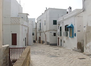
Castellaneta is a city and comune in the province of Taranto, in the Apulia region of Southern Italy, about 40 km (25 mi) from Taranto. Located in a territory spanning from the Murgia to the Ionian Sea, characterized by numerous gravina (ravines), it is part of the Comunità Montana della Murgia Tarantina.

Moncalvo Comune in Piedmont, Italy

Moncalvo is a village and comune in the Province of Asti in the Italian region Piedmont, located about 45 kilometres (28 mi) east of Turin and about 15 kilometres (9 mi) northeast of Asti on the national road SS 547 which links Asti to Casale Monferrato and Vercelli. Historically it was part of the state of Montferrat and was of particular importance during the early years of the Paleologi period of the marquisate. Its best-known inhabitants were the Baroque painter Guglielmo Caccia and ‘La Bella Rosin’, King Victor Emmanuel II’s favourite mistress and eventually wife.

Civezza Comune in Liguria, Italy

Civezza is a comune (municipality) in the Province of Imperia in the Italian region Liguria, located about 127 kilometres (79 mi) southwest of Genoa and about 7 kilometres (4 mi) west of Imperia. As of 31 December 2004, it had a population of 557 and an area of 3.8 square kilometres (1.5 sq mi).

Perinaldo Comune in Liguria, Italy

Perinaldo is a comune (municipality) in the Province of Imperia in the Italian region Liguria, located about 120 kilometres (75 mi) southwest of Genoa and about 30 kilometres (19 mi) west of Imperia.

Rezzo Comune in Liguria, Italy

Rezzo is a comune (municipality) in the Province of Imperia in the Italian region Liguria, located about 100 kilometres (62 mi) southwest of Genoa and about 20 kilometres (12 mi) northwest of Imperia.

Vicaria human settlement in Fourth Municipality of Naples, Italy

Vicaria, often known as Il Vasto, is one of the 30 quartieri of Naples, southern Italy, lying immediately to the east of the historical city centre.

Arroscia river in Italy

The Arroscia is an Italian river in the provinces of Imperia. and Savona.

Bonzo, Piedmont Frazione in Piedmont, Italy

Bonzo is a frazione of the municipality of Groscavallo, in Piedmont, northern Italy.

Saint Bartholomew, Brugherio religious building in Brugherio

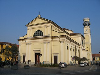
The Church of Saint Bartholomew is the cathedral and the oldest parish in Brugherio, Italy. It houses relics of the three Magi. It is characterised by its relatively high bell tower measuring 36.8 metres (121 ft).

Bergeggi (island) island

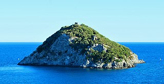
Bergeggi is an island which lies in the Ligurian Sea off the coast near the village of Bergeggi in the Province of Savona, Liguria, Italy.

Calvisio Frazione in Liguria, Italy

Calvisio is a frazione of the municipality of Finale Ligure, in Liguria, northern Italy.

Ferdinando di Diano Italian mathematician

Ferdinando di Diano da Diano, also known as Donatus Polienus, was an Italian mathematician, abbot, philosopher, and theologist.

Giara di Rezzo

The Giara di Rezzo is a 14-kilometre (8.7 mi) stream of Liguria, Italy.

Monte Monega Mountain in Italy

Monte Monega is a 1,882-metre (6,175 ft) mountain of the Ligurian Alps, in Italy.

Carmo di Brocchi Mountain in Italy

Carmo di Brocchi is a 1,610-metre (5,282 ft) mountain of the Ligurian Alps, in Italy.

Monte Spinarda Mountain in Italy

Monte Spinarda is a 1,357-metre (4,452 ft) mountain of the Ligurian Alps, in Italy.

Brevenna

The Brevenna is a 16.138-kilometre (10.028 mi) creek of Liguria, Italy.

Cima Altemberg Mountain in Italy

The Altemberg is a mountain in the Pennine Alps of north-western Italy; with an elevation of 2,395 m (7,858 ft) is the highest peak of the Alpi Cusiane.

Monte Civrari Mountain in Italy

The Monte Civrari is a mountain of the Graian Alps, with an elevation of 2,302 m.

Monte Antoroto Mountain in Italy

The Monte Antoroto is a mountain of the Ligurian Alps located in Piedmont.

References

  1. 1 2 Istat - 14º Censimento generale della popolazione e delle abitazioni
  2. "Limiti Amministrativi (Comunali, Provinciali, Regionali) sc. 1:25000". geoportale.regione.liguria.it. Regione Liguria. 2011. Retrieved 2018-02-13.
  3. 1 2 3 Debartolomeis, Luigi (1847). Notizie topografiche e statistiche sugli stati sardi (in Italian). Torino: Chirio e Mina. p. 154. Retrieved 22 January 2018.
  4. Andrea Pomati (2017-02-18). "Rezzo, presto al via i lavori sulla frana di Lavina". La Stampa (in Italian). Retrieved 2018-02-13.
  5. Il territorio - La via Marenca (PDF) (in Italian). Comune di Rezzo. Retrieved 2018-01-22.
  6. Del Giudice, Pasquale; Besta, Enrico (1925). Storia del diritto italiano (in Italian). 1. Hoepli. p. 606.
  7. 1 2 Gandolfo, Andrea (2005). "Rezzo". La provincia di Imperia: A-L (in Italian). Blu Edizioni.
  8. 1 2 Zuccagni-Orlandini, Attilio (1837). Corografia fisica, storica e statistica dell'Italia e delle sue isole corredata di un atlante (in Italian). p. 39.