Green-Wood Cemetery is a 478-acre (193 ha) cemetery in the western portion of Brooklyn, New York City. The cemetery is located between South Slope/Greenwood Heights, Park Slope, Windsor Terrace, Borough Park, Kensington, and Sunset Park, and lies several blocks southwest of Prospect Park. Its boundaries include, among other streets, 20th Street to the northeast, Fifth Avenue to the northwest, 36th and 37th Streets to the southwest, Fort Hamilton Parkway to the south, and McDonald Avenue to the east.

Calvary Cemetery is a Roman Catholic cemetery in Maspeth and Woodside, Queens, in New York City, New York, United States. With about three million burials, it has the largest number of interments of any cemetery in the United States. Established in 1848, Calvary Cemetery covers 365 acres (148 ha) and is owned by the Roman Catholic Archdiocese of New York and managed by the Trustees of St. Patrick's Cathedral.

Westminster Hall and Burying Ground is a graveyard and former church located at 519 West Fayette Street in Baltimore, Maryland, United States. It occupies the southeast corner of West Fayette and North Greene Street on the west side of downtown Baltimore. It sits across from the Baltimore VA hospital and is the burial site of Edgar Allan Poe (1809–1849). The complex was declared a national historic district in 1974.
Bayside Cemetery is a Jewish cemetery at 80-35 Pitkin Avenue in Ozone Park, Queens, New York City. It covers about 12 acres (4.9 ha) and has about 35,000 interments. It is bordered on the east by Acacia Cemetery, on the north by Liberty Avenue, on the west by Mokom Sholom Cemetery, and on the south by Pitkin Avenue.
The Cornell Family Cemetery, now officially designated the Richard Cornell Graveyard, is located on Gateway Boulevard. According to NYC Parks Department, the Cornell Burial Ground is on the west side of Caffrey Avenue north of New Haven Avenue in Far Rockaway, Queens in New York City.
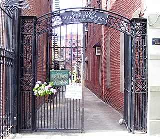
The New York Marble Cemetery is a burial ground established in 1830 in what is now the East Village of Manhattan. It occupies the interior of the block bounded by 2nd Street, Second Avenue, 3rd Street, and the Bowery. It is entered through an alleyway with an iron gate at each end, located between 41 and 43 Second Avenue. About 2,100 burials are recorded in the cemetery's written registers, most from prominent professional and merchant families in New York City.

The Prospect Hill Cemetery, located at 3202 Parker Street in the Prospect Hill neighborhood of North Omaha, Nebraska, United States, is believed to be the oldest pioneer cemetery in Omaha. It is between 31st and 33rd Streets and Parker and Grant Streets.
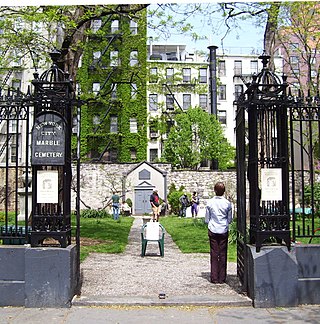
The New York City Marble Cemetery is a historic cemetery founded in 1831, and located at 52-74 East 2nd Street between First and Second Avenues in the East Village neighborhood of Manhattan, New York City. The cemetery has 258 underground burial vaults constructed of Tuckahoe marble on the site.
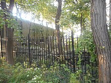
First Shearith Israel Graveyard, also known as Chatham Square Cemetery, is a tiny Jewish graveyard at 55-57 St. James Place in the Two Bridges neighborhood of Lower Manhattan, New York City. It is the oldest of three Manhattan graveyards currently maintained by Congregation Shearith Israel, which is itself the oldest Jewish congregation in North America. Today, the cemetery is a mere fragment of its original extent. Only about a hundred headstones and above ground tombs can still be seen in what remains of the old burial ground, which rises slightly above street level. It is the only remaining 17th century structure in Manhattan.

The Queens Historical Society, which was founded in 1968 by Margaret I. Carman after a merger with the Kingsland Preservation Commission, is dedicated to preserving the history and heritage of Queens, New York and interpreting the history of the borough as it relates to various historical periods. The historical society is the only museum about Queens' history within the borough and is located in Kingsland Homestead, which is a historic house museum within Weeping Beech Park.

Cedar Grove Cemetery is a nonsectarian cemetery in Flushing, Queens, New York. The cemetery occupies the former Spring Hill estate of colonial governor Cadwallader Colden.

The Sharp Burial Ground, also known as the Albany Avenue Cemetery, is located on Albany Avenue in Kingston, New York, United States. It is a small burying ground used during the middle decades of the 19th century, before larger rural cemeteries had become common but after churchyards had become too full for further burials. Later, when they did open, many bodies were removed to consolidate them with larger family plots there. Two former congressmen are still among those buried at Sharp.

Grace Episcopal Church Complex is a historic Episcopal church complex at 155-15 Jamaica Avenue in Jamaica, Queens, New York City, in U.S. state of New York. The complex includes the church, parish house, and cemetery. The church was built between 1861 and 1862. It is constructed of rough-cut sandstone and features a steeply pitched roof and tall, sharp spire in the Gothic Revival style. A chancel, designed by Cady, Berg & See, was added at the rear of the church in 1901-1902. The parish house, known as Grace Memorial House, was built in 1912. It is three-story brick building in the Tudor Revival style. The surrounding cemetery includes burials dating to 1734, when the church located at this site. Notable interments include Rufus King (1755–1827), Charles King (1789–1867) and William Duer (1743–1799).

Prospect Cemetery is a historic cemetery located in the Jamaica section of the New York City borough of Queens. It was established in 1668 and known as the "burring plas." The cemetery's original main gate was on Beaver Road which led from Sutphin Boulevard to Jamaica Avenue. The cemetery was generally known as the Presbyterian burial ground and is one of the few remaining Colonial cemeteries in Queens.

The Moore-Jackson Cemetery is a historic cemetery in the Woodside neighborhood of Queens in New York City, active from 1733 to about 1868. It is one of New York City's few remaining 18th-century cemeteries and is a New York City designated landmark. The burial ground occupies a five-sided site on 51st and 54th Streets between 31st and 32nd Avenues. While the cemetery spans about 20,000 square feet (1,900 m2), all of the surviving tombstones are placed along 54th Street. The cemetery was part of the estate of Samuel and Charity Moore, members of one of Queens's oldest families, and contains approximately 48 corpses.

Open Road Park is a small park in East Village, Manhattan, New York City, located east of First Avenue between 11th and 12th Streets. It is among the larger green spaces created in the East Village as a result of community organizing. The site of this park was taken over in 1993 by Open Road, a neighborhood nonprofit that developed the lot into a community garden and playground. Prior to its use as a park, the site was used for many purposes that reflect on the history of the surrounding neighborhood.
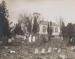
Seacord Cemetery is a historic cemetery located in the Wykagyl section the city of New Rochelle in Westchester County, New York. The cemetery is located to the south of the First Methodist Episcopal Church building at 1228 North Avenue. By the year 1787 the group which formed this church had become strong enough to buy a piece of property and erect a church. The graveyard adjoining the church on the south and west dates from the purchase of the church lot. The burial plot north of the church building is a family burying ground founded by Israel Seacord, owner of the farm.

The West Farms Soldiers Cemetery, at 2103 Bryant Avenue and 180th Street in the West Farms section of the Bronx in New York City, is the oldest public veterans' burial ground in the borough. The cemetery contains the remains of 40 US veterans including 2 from the War of 1812, 35 from the Civil War, 2 from the Spanish-American War, and 2 from the First World War. The cemetery is a New York City landmark, designated by the Landmarks Preservation Commission on August 2, 1967.