The Donas hill is in Poland in the Pomerania region, within the borders of the City of Gdynia, in the Dabrowa district. Its height is 205.7 m. In March 1945, a battle took place between the Red Army and the Germans. On the top, there is a GSM tower erected, with a visitors terrace 232 m above sea level. The view includes Gdańsk, Gdynia, Gdańsk Bay, Hel Peninsula and Wiezyca mountain, the highest in the Pomerania region. Nearby is the old and abandoned cemetery that served the village of Kolonia Chwaszczynska's population.

Sim River is a river in Chelyabinsk Oblast and the Republic of Bashkortostan in Russia. It is a tributary of the Belaya River, part of the Volga watershed. Its length is 239 kilometers (149 mi).

Ciosek is a village in the administrative district of Gmina Sośno, within Sępólno County, Kuyavian-Pomeranian Voivodeship, in north-central Poland. It lies approximately 6 kilometres (4 mi) north-east of Sośno, 14 km (9 mi) east of Sępólno Krajeńskie, and 40 km (25 mi) north-west of Bydgoszcz.
Osiedle Bondary is a village in the administrative district of Gmina Michałowo, within Białystok County, Podlaskie Voivodeship, in north-eastern Poland, close to the border with Belarus.

Widawa is a village in Łask County, Łódź Voivodeship, in central Poland. It is the seat of the gmina called Gmina Widawa. It lies approximately 22 kilometres (14 mi) south-west of Łask and 53 km (33 mi) south-west of the regional capital Łódź.

Wielki Buczek is a village in the administrative district of Gmina Lipka, within Złotów County, Greater Poland Voivodeship, in west-central Poland. It lies approximately 8 kilometres (5 mi) south of Lipka, 19 km (12 mi) north-east of Złotów, and 118 km (73 mi) north of the regional capital Poznań.

Jeszkotle is a village in the administrative district of Gmina Grodków, within Brzeg County, Opole Voivodeship, in south-western Poland. It lies approximately 9 kilometres (6 mi) west of Grodków, 25 km (16 mi) south-west of Brzeg, and 49 km (30 mi) west of the regional capital Opole.

Zdrzewno is a village in the administrative district of Gmina Wicko, within Lębork County, Pomeranian Voivodeship, in northern Poland. It lies approximately 6 kilometres (4 mi) east of Wicko, 14 km (9 mi) north of Lębork, and 69 km (43 mi) north-west of the regional capital Gdańsk.

Dębogórze-Wybudowanie is a village in the administrative district of Gmina Kosakowo, within Puck County, Pomeranian Voivodeship, in northern Poland. It lies approximately 3 kilometres (2 mi) west of Kosakowo, 13 km (8 mi) south of Puck, and 28 km (17 mi) north-west of the regional capital Gdańsk.

Wycinki is a village in the administrative district of Gmina Osiek, within Starogard County, Pomeranian Voivodeship, in northern Poland. It lies approximately 2 kilometres (1 mi) south of Osiek, 29 km (18 mi) south of Starogard Gdański, and 74 km (46 mi) south of the regional capital Gdańsk.

Miłoszewo is a village in the administrative district of Gmina Linia, within Wejherowo County, Pomeranian Voivodeship, in northern Poland. It lies approximately 6 kilometres (4 mi) east of Linia, 24 km (15 mi) south-west of Wejherowo, and 42 km (26 mi) west of the regional capital Gdańsk.

Załom is a village in the administrative district of Gmina Goleniów, within Goleniów County, West Pomeranian Voivodeship, in north-western Poland. It lies approximately 14 kilometres (9 mi) south-west of Goleniów and 11 km (7 mi) east of the regional capital Szczecin.

Przybkówko is a village in the administrative district of Gmina Barwice, within Szczecinek County, West Pomeranian Voivodeship, in north-western Poland. It lies approximately 3 kilometres (2 mi) south of Barwice, 23 km (14 mi) west of Szczecinek, and 121 km (75 mi) east of the regional capital Szczecin.

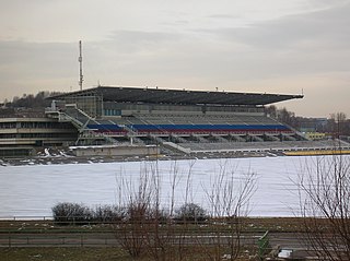
The Krylatskoye Rowing Canal is a canoe sprint and rowing venue located in the Krylatskoye Sports Complex in Moscow, Russia.

Poljanice is a village in the municipality of Višegrad, Bosnia and Herzegovina.

Tupeši is a village in the municipality of Višegrad, Bosnia and Herzegovina.
Guinea Mills is an unincorporated community in Cumberland County, in the U.S. state of Virginia.

Langeland Bridge is a road bridge that connects the islands Langeland and Siø. From Siø a connection exists via Tåsinge to Funen. It was built from 1960 to 1962.

Congress of Lushnjë Museum is a museum in Lushnjë, Albania. The Congress of Lushnjë was held here in 1920. In 1970, the building was turned into a museum devoted to patriotism. It contains numerous photographs and original documents related to Albania's struggle against Fascism. The white building has 5 bays on the middle floor and 2 bays on the top floor.
Kosse or Cosse was a quarter of western Königsberg, Germany. Its territory is now part of the Tsentralny District of Kaliningrad, Russia.


