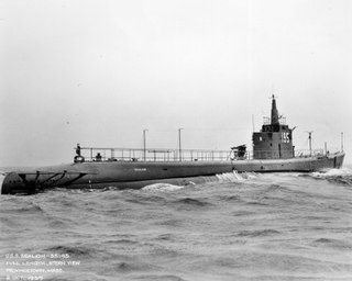
USS Sealion (SS-195), a Sargo-class submarine, was the first ship of the United States Navy to be named for the sea lion, any of several large, eared seals native to the Pacific.

Douglas West was a House of Keys constituency in Douglas, Isle of Man. It elected 2 MHKs.

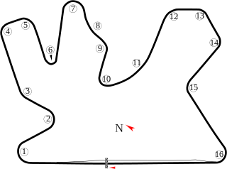
Losail International Circuit is a motor racing circuit located just outside in the town of Lusail, north of Doha, Qatar.

The Qatar motorcycle Grand Prix is a motorcycling event that is part of the FIM Grand Prix motorcycle racing season.

Nininger is a ghost town in section 18 of Nininger Township in Dakota County, Minnesota, United States.

Liberty Pole is an unincorporated community in Vernon County, Wisconsin in the town of Franklin.
Bù Đăng is a rural district of Bình Phước Province in the Southeast region of Vietnam. As of 2003 the district had a population of 108,855. The district covers an area of 1488 km². The district capital lies at Đức Phong.

Mąkoszyn is a village in the administrative district of Gmina Szubin, within Nakło County, Kuyavian-Pomeranian Voivodeship, in north-central Poland. It lies approximately 7 kilometres (4 mi) south of Szubin, 24 km (15 mi) south-east of Nakło nad Notecią, and 24 km (15 mi) south-west of Bydgoszcz.

Dalkowo is a village in the administrative district of Gmina Więcbork, within Sępólno County, Kuyavian-Pomeranian Voivodeship, in north-central Poland. It lies approximately 4 kilometres (2 mi) north of Więcbork, 8 km (5 mi) south of Sępólno Krajeńskie, and 46 km (29 mi) north-west of Bydgoszcz.

Chankatagh is a village in the Tartar District of Azerbaijan, currently under the control of Armenian forces.

Mollalar is a village in the Lachin Rayon of Azerbaijan.
Łazy-Dąbrowa is a village in the administrative district of Gmina Sulejów, within Piotrków County, Łódź Voivodeship, in central Poland.
Bystre-Chrzany is a village in the administrative district of Gmina Krzynowłoga Mała, within Przasnysz County, Masovian Voivodeship, in east-central Poland.

Żółno is a settlement in the administrative district of Gmina Parchowo, within Bytów County, Pomeranian Voivodeship, in northern Poland. It lies approximately 8 kilometres (5 mi) south-east of Parchowo, 18 km (11 mi) east of Bytów, and 61 km (38 mi) west of the regional capital Gdańsk.

Koteże is a village in the administrative district of Gmina Starogard Gdański, within Starogard County, Pomeranian Voivodeship, in northern Poland. It lies approximately 6 kilometres (4 mi) south-west of Starogard Gdański and 50 km (31 mi) south of the regional capital Gdańsk.

Subkowskie Pole is a settlement in the administrative district of Gmina Subkowy, within Tczew County, Pomeranian Voivodeship, in northern Poland. It lies approximately 2 kilometres (1 mi) south of Subkowy, 13 km (8 mi) south of Tczew, and 43 km (27 mi) south of the regional capital Gdańsk.

Sierakowo is a village in the administrative district of Gmina Police, within Police County, West Pomeranian Voivodeship, in north-western Poland, close to the German border. It lies approximately 6 kilometres (4 mi) south-west of Police and 12 km (7 mi) north-west of the regional capital Szczecin.
Nowe Linie is a village in the administrative district of Gmina Bielice, within Pyrzyce County, West Pomeranian Voivodeship, in north-western Poland.
Đồng Phú is a rural district (huyện) of Bình Phước Province in the Đông Nam Bộ region of Vietnam. As of 2003 the district had a population of 75,573. The district covers an area of 929 km². The district capital lies at Tân Phú.

Yumurtalık Island is a small Mediterranean island in Yumurtalık ilçe (district) of Adana Province, Turkey. The midpoint of the island is at 36°46′09″N35°47′49″E. It is situated about 300 metres (980 ft) to the east of the port.


