Shelby County Airport is a public use airport located four nautical miles (7 km) southeast of the central business district of Alabaster, a city in Shelby County, Alabama, United States. It is owned by the Shelby County Commission. The airport is situated in the city of Calera.
Clayton Municipal Airpark is a town owned, public use airport located two nautical miles (4 km) east of the central business district of Clayton, a town in Union County, New Mexico, United States. It is included in the National Plan of Integrated Airport Systems for 2011–2015, which categorized it as a general aviation facility.

Marana Regional Airport, also known as Marana Northwest Regional Airport or Avra Valley Airport, is a non-towered, general aviation airport about 15 mi northwest of Tucson in Marana a town in Pima County, Arizona, United States. In 1999, the airport was purchased from Pima County by the town of Marana.

Bessemer Airport is a city-owned public-use airport located three nautical miles southeast of the central business district of Bessemer, a city in Jefferson County, Alabama, United States. According to the FAA's National Plan of Integrated Airport Systems for 2009–2013, it is categorized as a reliever airport for the Birmingham-Shuttlesworth International Airport.
Genesee County Airport is a county-owned, public-use airport in Genesee County, New York, United States. It is located two nautical miles (4 km) north of the central business district of Batavia, a city located within the Town of Batavia.
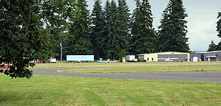
Scappoose Airport is a public use airport located one nautical mile (1.85 km) northeast of the central business district of Scappoose, in Columbia County, Oregon, United States. It is owned and operated by the Port of Columbia County, an Oregon port district and municipal corporation, on behalf of district residents. According to the FAA's National Plan of Integrated Airport Systems for 2009–2013, it is categorized as a general aviation airport.

Tillamook Airport is a public use airport located 3 miles (4.8 km) south of the central business district of Tillamook, a city in Tillamook County, Oregon, United States. It is owned by the Port of Tillamook Bay. According to the FAA's National Plan of Integrated Airport Systems for 2009–2013, it is categorized as a general aviation facility.
H. L. Sonny Callahan Airport is a public-use airport located three nautical miles southeast of the central business district of Fairhope, a city in Baldwin County, Alabama, United States. It is owned by the Fairhope Airport Authority.

Canandaigua Airport is a public-use airport in Ontario County, New York, United States. It is owned by the Ontario County IDA and is located three nautical mile (5.56 km) northwest of the central business district of the City of Canandaigua. According to the FAA's National Plan of Integrated Airport Systems for 2007-2011, it is categorized as a reliever airport.
Le Roy Airport is a public use airport in Genesee County, New York, United States. It is located two nautical miles (3.7 km) east of the central business district of the Le Roy, a village in the Town of Le Roy. According to the FAA's National Plan of Integrated Airport Systems for 2007–2011, it is categorized as a reliever airport.
Randall Airport is a public use airport in Orange County, New York, United States. It is owned by Aerodrome Dev Corp and is located two nautical miles (3.74 km) southeast of the central business district of the City of Middletown. According to the FAA's National Plan of Integrated Airport Systems for 2007–2011, it is categorized as a reliever airport.
Whitford's Airport is a public use airport in Cayuga County, New York, United States. It is owned by John Whitford and is located two nautical miles northeast of the central business district of the Village of Weedsport. According to the FAA's National Plan of Integrated Airport Systems for 2007-2011, it is categorized as a reliever airport.
Pine Hill Airport is a public use airport located five nautical miles southwest of Albion, a village in Orleans County, New York, United States. The airport property is owned by Haines Family Farm and leased by the Vintage Aircraft Group.
Huntington Municipal Airport is a city-owned, public-use airport located three nautical miles southeast of the central business district of Huntington, a city in Huntington County, Indiana, United States. According to the FAA's National Plan of Integrated Airport Systems for 2009–2013, it was classified as a general aviation airport.
Independence Municipal Airport is a city-owned public-use airport located three nautical miles (6 km) southwest of the central business district of Independence, a city in Buchanan County, Iowa, United States. As per the FAA's National Plan of Integrated Airport Systems for 2009-2013, it is classified as a general aviation airport.
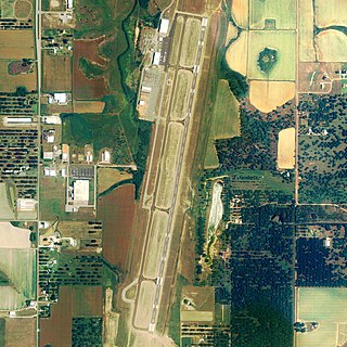
Midland Airpark is a public airport three miles north of Midland, in Midland County, Texas. The FAA's National Plan of Integrated Airport Systems for 2009–2013 categorized it as a general aviation facility.
St. Johns Industrial Air Park is a city-owned public-use airport located 1.15 miles north of the central business district of St. Johns, a city in Apache County, Arizona, United States. The airport is included in the FAA's National Plan of Integrated Airport Systems for 2009–2013, which categorizes it as a general aviation facility. The NPIAS report for 2015–2019 classified the Air Park again as General Aviation, in the "Basic" asset category, for airports with the lowest levels of activity.
Malone-Dufort Airport is two miles west of Malone, a village in the Town of Malone, Franklin County, New York. The FAA's National Plan of Integrated Airport Systems for 2009–2013 categorized it as a general aviation facility.
Hornell Municipal Airport is a city-owned public-use airport located three nautical miles (6 km) north of the central business district of Hornell, a city in Steuben County, New York, United States. It is included in the National Plan of Integrated Airport Systems for 2011–2015, which categorized it as a general aviation airport.
New Castle-Henry County Municipal Airport is a public use airport located four nautical miles southeast of the central business district of New Castle, a city in Henry County, Indiana, United States. It is included in the National Plan of Integrated Airport Systems for 2011–2015, which categorized it as a general aviation facility.