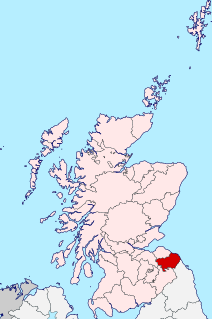
Berwickshire is a historic county, registration county and lieutenancy area in southeastern Scotland, on the English border. It takes its name from Berwick-upon-Tweed, which was part of the Kingdom of Northumbria at the time of the county's formation, but became part of England in 1482 after several centuries of swapping back and forth between the two kingdoms

The former Royal Burgh of Lauder is a town in the Scottish Borders in the historic county of Berwickshire. On the Southern Upland Way, the burgh lies 27 miles (43 km) southeast of Edinburgh, on the western edge of the Lammermuir Hills.

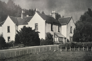
Coldingham is a village and parish in Berwickshire, Scottish Borders, on Scotland's southeast coastline, north of Eyemouth.

Oldhamstocks or Aldhamstocks is a civil parish and small village in the east of East Lothian, Scotland, adjacent to the Scottish Borders and overlooking the North Sea. It is located 6 miles (10 km) south-east of Dunbar and has a population of 193. The church was consecrated by Bishop David de Bernham, 19 October 1242. Its chancel is a fine example of late Gothic — probably fifteenth-century work.

Ednam is a small village near Kelso in the Scottish Borders area of Scotland.
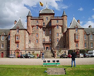
Thirlestane Castle is a castle set in extensive parklands near Lauder in the Borders of Scotland. The site is aptly named Castle Hill, as it stands upon raised ground. However, the raised land is within Lauderdale, the valley of the Leader Water. The land has been in the ownership of the Maitland family since 1587, and Thirlestane served as the seat of the Earls of Lauderdale. The castle was substantially extended in the 1670s by the first and only Duke of Lauderdale. Further additions were made in the 19th century. The castle is now cared for by a charitable trust, and is open to the public.

The Tron Kirk is a former principal parish church in Edinburgh, Scotland. It is a well-known landmark on the Royal Mile. It was built in the 17th century and closed as a church in 1952. Having stood empty for over fifty years, it was used as a tourist information centre for several years in the mid 2000's and, more recently, was the site of the Edinburgh World Heritage Exhibition and John Kay’s book and gift shop.

Stenton is a parish and village in East Lothian, Scotland. It is bounded on the north by parts of the parishes of Prestonkirk and Dunbar, on the east by Spott and on the west by Whittingehame. The name is said to be of Saxon derivation. The village has a number of houses, a school, and a church.
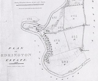
Edrington is a medieval estate occupying the lower part of Mordington parish in Berwickshire, Scottish Borders, Scotland, five miles (8.0 km) west of Berwick-upon-Tweed. From probably the 14th century, if not earlier, a castle occupied the steep hill above the mill of the same name on the Whiteadder Water. The castle ruin is still marked on today's Ordnance Survey maps, and still appears in locality references in The Berwickshire News. The principal farm of the estate is Edrington Mains.
Foulden is a civil parish and village in the Berwickshire area of Scottish Borders, Scotland, situated not far above the Whiteadder Water, and 7 miles (11 km) west of Berwick-upon-Tweed.

Mordington is an agricultural parish in the extreme south-east of Berwickshire in the Scottish Borders region. It is five miles from Berwick-upon-Tweed and borders Northumberland to the east, and south, Foulden to the west, and Lamberton to the north. The parish is bisected by the A6105 Berwick to Duns road. The lower part of the parish is covered by the Edrington estate. It is possibly the warmest parish in Scotland; the annual hours of sunshine are said to be almost as high as at Dunbar, which records the most hours in Scotland.
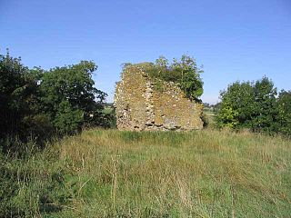
Whitslaid Tower was an ancient Berwickshire seat of the Lauder family for over 300 years. It is today a ruin high above the eastern bank of the Leader Water, 2 miles (3.2 km) south of the burgh of Lauder, in the Scottish Borders. In feudal times it fell within a detached segment of the King's personal Barony of Renfrew.

Eccles is a village and agricultural parish near Kelso in Berwickshire in the Scottish Borders area of Scotland. The village is conjoined with Birgham and Leitholm.
Smailholm is a small village in the historic county of Roxburghshire in south-east Scotland. It is at grid reference NT648364 and straddles the B6397 Gordon to Kelso road. The village is almost equidistant from both, standing 6 miles (10 km) northwest of the abbey town of Kelso. Since local government reorganisation in Scotland in the early 1970s, Smailholm has been part of the Scottish Borders Council.
Polwarth Parish Church was a member church of the Church of Scotland before closing in 2004. It is situated atop a mound off a minor road leading from the A6105, Greenlaw to Duns road in the old county of Berwickshire, now privately owned by the Letts family who live in the adjacent Polwarth Manse and is available for weddings. It lies 4.0 miles (6.4 km) south–west of Duns and 3.5 miles (5.6 km) east of Greenlaw at grid reference NT749494.
Ednam Church is a member church of the Church of Scotland and is co–joined with Kelso North Church in Kelso. Ednam is in the old county of Roxburghshire now part of the Scottish Borders Council. Ednam is 3.0 miles (4.8 km) NNE of Kelso on the B6461 road and is at grid reference NT737371

Legerwood is a village by the Eden Water, in the Scottish Borders area of Scotland, near Lauder, near the Southern Upland Way.

Edrom is a parish and small village in the pre-1975 ancient county of Berwickshire, now an administrative area of the Scottish Borders region of Scotland.
Channelkirk is a parish and community council area in the north-west corner of the historic county of Berwickshire in the Scottish Borders area of Scotland, forming the upper part of the ancient district of Lauderdale, while the parish of Lauder forms the lower part. The Community Council has the name Oxton and Channelkirk, Oxton being the main village of the parish. It was formerly in the Ettrick and Lauderdale district of Borders Region. A small strip of land along the northern boundary of the parish was added to Ettrick and Lauderdale district and thus also to the community council area, in the Brothershiels area, in 1988.
Boon is a farm and former barony located near Lauder, Scotland.

