
Leicester is a city and unitary authority area in the East Midlands of England, and the county town of Leicestershire. The city lies on the River Soar and close to the eastern end of the National Forest. It is to the north-east of Birmingham and Coventry, south of Nottingham, and west of Peterborough.

Kirby Muxloe is a village and civil parish that forms part of the Blaby district of Leicestershire, England. Located to the west of Leicester, its proximity to the city causes it to form part of the Leicester Urban Area. The Leicester Forest East parish border runs along the Hinckley Road A47. According to the 2001 census, the parish had a population of 4,523, increasing to 4,667 at the 2011 census.
Enclosure was the legal process in England of consolidating (enclosing) small landholdings into larger farms since the 13th century. Once enclosed, use of the land became restricted and available only to the owner, and it ceased to be common land for communal use. In England and Wales the term is also used for the process that ended the ancient system of arable farming in open fields. Under enclosure, such land is fenced (enclosed) and deeded or entitled to one or more owners. The process of enclosure began to be a widespread feature of the English agricultural landscape during the 16th century. By the 19th century, unenclosed commons had become largely restricted to rough pasture in mountainous areas and to relatively small parts of the lowlands.

The Forest of Dean is a geographical, historical and cultural region in the western part of the county of Gloucestershire, England. It forms a roughly triangular plateau bounded by the River Wye to the west and northwest, Herefordshire to the north, the River Severn to the south, and the City of Gloucester to the east.

Lord of the manor is a title given to a person holding the lordship of a manor in the Anglo-Saxon system of manorialism which emanated from feudalism in English and Irish history. In modern England and Wales, it is recognised as a form of property, one of three elements of a manor that may exist separately or be combined, and may be held in moieties:
- the title ;
- the manorial, comprising the manor and/or its land; and
- the seignory, rights granted to the titular holder of the manor.
The Inclosure Acts use an old or formal spelling of the word now more usually spelt "enclosure". They cover enclosure of open fields and common land in England and Wales, creating legal property rights to land that was previously held in common. Between 1604 and 1914, over 5,200 individual enclosure acts were passed, affecting 6.8 million acres.

Knighton is a residential suburban area of Leicester, situated between Clarendon Park to the north, Stoneygate to the east, Oadby and Wigston to the south and the Saffron Lane estate to the west.
The Personal Rule was the period from 1629 to 1640, when King Charles I of England, Scotland and Ireland ruled without recourse to Parliament. The King claimed that he was entitled to do this under the Royal Prerogative.

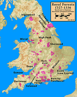
A royal forest, occasionally "Kingswood", is an area of land with different definitions in England, Wales, and Scotland. The term forest in the ordinary modern understanding refers to an area of wooded land; however, the original medieval sense was closer to the modern idea of a "preserve" – i.e. land legally set aside for specific purposes such as royal hunting – with less emphasis on its composition. There are also differing and contextual interpretations in Continental Europe derived from the Carolingian and Merovingian legal systems.
The Wychwood, or Wychwood Forest, is an area now covering a small part of rural Oxfordshire. In past centuries the forest covered a much larger area, since cleared in favour of agriculture, villages and towns. However, the forest's area has fluctuated. Parts cleared for agriculture during Britain's centuries under Roman rule later reverted to forest. The existence of the ancient Wychwood is recognised by the authoritative Victoria County History, but the planned Volume XIX has yet to be completed.

Braunstone is a civil parish and is the largest parish within the district of Blaby in Leicestershire, England, now known as the Town of Braunstone or more commonly, Braunstone Town. In 2007 the population was around 15,000. There are around 7,500 households including Thorpe Astley. At the 2011 census the population of the civil parish had increased to 16,850.

Hanbury is a rural village in Worcestershire, England near Droitwich Spa and the M5 motorway.
The Western Rising was a series of riots which took place during 1626–1632 in Gillingham Forest on the Wiltshire-Dorset border, Braydon Forest in Wiltshire, and the Forest of Dean, Gloucestershire, in response to disafforestation of royal forests, sale of royal lands and enclosure of property by the new owners. Disafforestation is a change in legal status that allows the land to be sold normally, rather than being preserved as a forest. Enclosure takes the land out of common use, denying access to non-owners who had previously used it.
Warren James (1792–1841) was a rebel leader in the Forest of Dean, England.
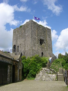
The Honour of Clitheroe is an ancient grouping of manors and royal forests centred on Clitheroe Castle in Lancashire, England; an honour traditionally being the grant of a large landholding complex, not all of whose parts are contiguous. In the case of Clitheroe, this complex was loosely clustered around the ancient wapentake of Blackburnshire.

Feckenham Forest was a royal forest, centred on the village of Feckenham, covering large parts of Worcestershire and west Warwickshire. It was not entirely wooded, nor entirely the property of the King. Rather, the King had legal rights over game, wood and grazing within the forest, and special courts imposed harsh penalties when these rights were violated. Courts and the forest gaol were located at Feckenham and executions took place at Gallows Green near Hanbury.

In English law, Welsh law and Irish law, a manor is an estate in land which includes the right to hold a manorial court. The Lord of the manor, through the manorial court, has jurisdiction over those who live within the lands of the manor. The proper unit of tenure under the feudal system is the fee, on which the manor became established through the process of time, akin to the modern establishment of a "business" upon a freehold site. The manor is nevertheless often described as the basic feudal unit of tenure and is historically connected with the territorial divisions of the march, county, hundred, parish and township.
The Erection of Cottages Act 1588 was an Act of the Parliament of England that prohibited the construction - in most parts of England—of any dwelling that did not have at least 4 acres assigned to it out of the freehold or other heritable land belonging to the person responsible for its construction.

Ashley Park is a private residential neighbourhood at Walton-on-Thames in Surrey. Its central feature was a grandiose English country house, at times enjoying associated medieval manorial rights, which stood on the site, with alterations, between 1605 and the early 1920s. Its owners included Charles Sackville, 2nd Duke of Dorset, in the 18th century and members of the Sassoon family around the turn of the 20th century.

The Forest of Knaresborough was a royal hunting forest in Yorkshire, England. It covered an area of some 45 square miles (120 km2) west and south of the town of Knaresborough, between the River Nidd and the River Wharfe, then in the West Riding of Yorkshire and now in North Yorkshire.
