
Asia is Earth's largest and most populous continent, located primarily in the Eastern and Northern Hemispheres. It shares the continental landmass of Eurasia with the continent of Europe, and the continental landmass of Afro-Eurasia with Africa and Europe. Asia covers an area of 44,579,000 square kilometres (17,212,000 sq mi), about 30% of Earth's total land area and 8.7% of the Earth's total surface area. The continent, which has long been home to the majority of the human population, was the site of many of the first civilizations. Its 4.7 billion people constitutes roughly 60% of the world's population.

Dar es Salaam or commonly known as Dar, is the largest city and financial hub of Tanzania. It is also the capital of Dar es Salaam Region. With a population of over six million people, Dar is the largest city in East Africa and the seventh-largest in Africa. Located on the Swahili coast, Dar es Salaam is an important economic centre and is one of the fastest-growing cities in the world.
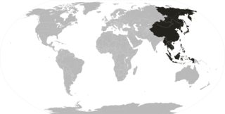
The Far East is a term to refer to the geographical regions that includes East and Southeast Asia as well as the Russian Far East to a lesser extent.
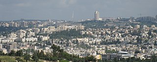
Jerusalem is a city in Western Asia. Situated on a plateau in the Judaean Mountains between the Mediterranean and the Dead Sea, it is one of the oldest cities in the world, and is considered holy for the three major Abrahamic religions: Judaism, Christianity, and Islam. The city straddles the Green Line between Israel and the West Bank; both Israelis and Palestinians claim Jerusalem as their capital, as Israel controls the entire city and maintains its primary governmental institutions there while the Palestinian National Authority and Palestine Liberation Organization ultimately foresee it as the seat of power for the State of Palestine. Due to this long-running dispute, neither claim is widely recognized internationally.
The Cree are a North American Indigenous people. They live primarily in Canada, where they form one of that country's largest First Nations.

Port of Spain, officially the City of Port of Spain, is the capital city of Trinidad and Tobago, and the third largest municipality after Chaguanas and San Fernando. The city has a municipal population of 37,074, an urban population of 81,142 and a transient daily population of 250,000. It is located on the Gulf of Paria, on the northwest coast of the island of Trinidad and is part of a larger conurbation stretching from Chaguaramas in the west to Arima in the east with an estimated population of 600,000.

The Western Hemisphere is the half of Earth which lies west of the prime meridian and east of the antimeridian. The other half is called the Eastern Hemisphere. In geopolitical terms, the context in which the term is most often used, the Encyclopedia Britannica defines it as "North and South America and the surrounding waters. Longitudes 20°W and 160°E are often considered its boundaries." It may be used in a cultural or geopolitical sense as a synonym for the "New World".

East Carolina University (ECU) is a public research university in Greenville, North Carolina. It is the fourth largest university in North Carolina.

Primorsky Krai, informally known as Primorye and translated in full as Maritime Territory, is a federal subject of Russia, located in the Far East region of the country and is a part of the Far Eastern Federal District. The city of Vladivostok is the administrative center of the krai, and the second largest city in the Russian Far East, after Khabarovsk. The krai has the largest economy among the federal subjects in the Russian Far East, and a population of 1,956,497 as of the 2010 Census.

Midtown Manhattan is the central portion of the New York City borough of Manhattan and serves as the city's primary central business district. Midtown is home to some of the city's most prominent buildings, including the Empire State Building, the Chrysler Building, the Hudson Yards Redevelopment Project, the headquarters of the United Nations, Grand Central Terminal, and Rockefeller Center, as well as tourist destinations such as Broadway and Times Square.
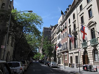
The Upper East Side, sometimes abbreviated UES, is a neighborhood in the borough of Manhattan in New York City, bounded by 96th Street to the north, the East River to the east, 59th Street to the south, and Central Park/Fifth Avenue to the west. The area incorporates several smaller neighborhoods, including Lenox Hill, Carnegie Hill, and Yorkville. Once known as the Silk Stocking District, it has long been the most affluent neighborhood in New York City.

The Lower East Side, sometimes abbreviated as LES and sometimes referred to as Loisaida, is a historic neighborhood in the southeastern part of the New York City borough of Manhattan, roughly between the Bowery and the East River from Canal to Houston streets. Traditionally an immigrant, working-class neighborhood, it began rapid gentrification in the mid-2000s, prompting the National Trust for Historic Preservation to place the neighborhood on their list of America's Most Endangered Places.
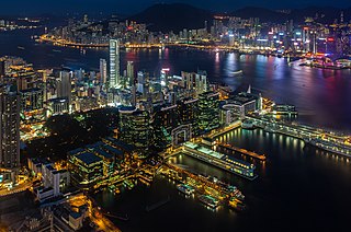
Tsim Sha Tsui, often abbreviated as TST, is an urban area in southern Kowloon, Hong Kong. The area is administratively part of the Yau Tsim Mong District. Tsim Sha Tsui East is a piece of land reclaimed from the Hung Hom Bay now east of Tsim Sha Tsui. The area is bounded north by Austin Road and in the east by Hong Chong Road and Cheong Wan Road.

Western Asia, West Asia, or Southwest Asia, is the westernmost subregion of the larger geographical region of Asia, as defined by some academics, UN bodies and other institutions. It is almost entirely a part of the Middle East, and includes Anatolia, the Arabian Peninsula, Iran, Mesopotamia, the Levant, the island of Cyprus, the Sinai Peninsula, and partly the Caucasus Region (Transcaucasia). The region is considered to be separated from Africa by the Isthmus of Suez in Egypt, and separated from Europe by the waterways of the Turkish Straits and the watershed of the Greater Caucasus. Central Asia lies to its northeast, while South Asia lies to its east. Eight seas surround the region (clockwise): the Aegean Sea, the Black Sea, the Caspian Sea, the Persian Gulf, the Arabian Sea, the Gulf of Aden, the Red Sea, and the Mediterranean Sea.

UTC−05:00 is an identifier for a time offset from UTC of −05:00. In North America, it is observed in the Eastern Time Zone during standard time, and in the Central Time Zone during the other eight months. The western Caribbean uses it year round.
The National Football Conference – Eastern Division or NFC East is one of the four divisions of the National Football Conference (NFC) in the National Football League (NFL). It currently has four members: the Dallas Cowboys, New York Giants, Philadelphia Eagles, and the Washington Commanders.
Rounds Mountain, 2,257 feet (688 m), is a prominent peak in the Taconic Mountains of western Massachusetts and adjacent New York. The west side of the mountain and summit are located in New York; the east side is located within Massachusetts. The summit a bald; the slopes are wooded with northern hardwood tree species. It is notable for its views of the Hudson River Valley to the west and the Green River and Kinderhook Creek valleys of Hancock, Massachusetts to the east. The 35 mi (56 km) Taconic Crest Trail traverses the mountain. Much of the upper slopes and summit are within protected conservation land.

Churfürsten is a mountain range in the Canton of St. Gallen, Switzerland. They form the natural boundary between the canton's Toggenburg and Sarganserland districts. They are the southernmost range of the Appenzell Alps, separated from the Glarus Alps by the Seez river and Walensee. They consist of a limestone ridge running east to west, with the individual peaks formed by erosion. The ridge is defined much more sharply to the south than to the north, with an almost vertical drop of several hundred meters towards Walenstadtberg and eventually Lake Walensee at 419 m. The southern slope of the range was significantly formed by the Rhine Glacier during the Würm glaciation.
Rondebosch East is a residential suburb of Cape Town, South Africa, about 7 kilometres (4.3 mi) south-east of the city centre. As the name suggests, it is located to the east of the neighbouring suburb of Rondebosch. As of 2001 it had a population of approximately 4,600 people in an area of just over 1 square kilometre (0.4 sq mi).


