Related Research Articles

Burns Lake is a rural village in the North-western-Central Interior of British Columbia, Canada, incorporated in 1923. The village had a population of 1,779 as of the 2016 Census.
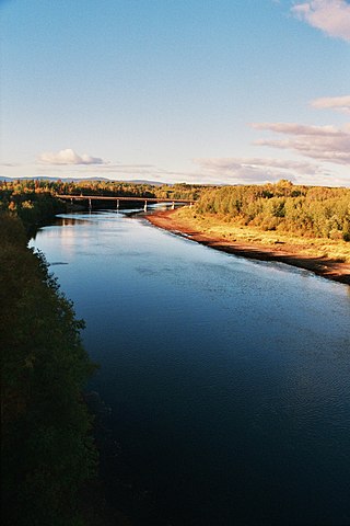
The Nechako River arises on the Nechako Plateau east of the Kitimat Ranges of the Coast Mountains of British Columbia, Canada, and flows north toward Fort Fraser, then east to Prince George where it enters the Fraser River. "Nechako" is an anglicization of netʃa koh, its name in the indigenous Carrier language which means "big river".
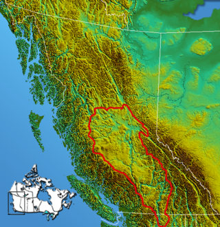
The Interior Plateau comprises a large region of the Interior of British Columbia, and lies between the Cariboo and Monashee Mountains on the east, and the Hazelton Mountains, Coast Mountains and Cascade Range on the west. The continuation of the plateau into the United States is known there as the Columbia Plateau.

Fort Fraser is an unincorporated village of about 500 people, situated near the base of Fraser Mountain, close to the village municipality of Fraser Lake and the Nechako River. It can be found near the geographical centre of British Columbia, Canada, 44 km (27 mi) west of Vanderhoof on the Yellowhead Highway. Originally established in 1806 as a North West Company fur trading post by the explorer Simon Fraser, it is one of present-day British Columbia's oldest permanent European-founded settlements. The area around the community is also recorded as the site of the first land in British Columbia cultivated by non-First Nations people.
The Stuart River or Nak'alkoh is one of the largest tributaries of the Nechako River in northeastern British Columbia, Canada. The Nechako is in turn one the more important tributaries of the Fraser River. The Stuart River flows 187 kilometres (116 mi) from Stuart Lake to its junction with the Nechako River. The river drains a portion of the Nechako Plateau—a gently-rolling region characterized by small lakes and tributaries. Low but impressive ridges interact with the river, creating high bluffs and hoodoos.

Beaumont Provincial Park is a provincial park located at the southeast end of Fraser Lake, between Fort Fraser and the town of Fraser Lake, British Columbia, approximately 40 km west of Vanderhoof, British Columbia. The park contains the site of the original Fort Fraser.
Stuart River Provincial Park is a provincial park in British Columbia, Canada. It is located in two sections north and northwest of Vanderhoof along the Stuart River southeast of Stuart Lake and the city of Fort St. James. The upper section is located at 54°13′20″N124°00′00″W and comprises c.7391 ha. while the lower, eastern section is centred at 54°03′00″N123°37′00″W and comprises c.3390 ha. and is within the Greater Prince George area. The upper site, which is located around the confluence of the Stuart and Nechako Rivers, includes the site of Chinlac, a Dakelh village whose inhabitants were massacred and enslaved by the Tsilhqot'in of Anahim Lake c. 1745.
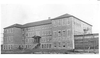
Lejac Residential School was a Canadian residential school in British Columbia that operated from 1922 to 1976 by the Roman Catholic Church under contract with the Government of Canada.

Nautley River drains Fraser Lake into the Nechako River in the Central Interior of British Columbia, Canada.
The Nadleh Whut'en First Nation is a First Nations government of the Dakelh people, whose territory is located in the Central Interior of British Columbia, Canada, around the east end of Fraser Lake. The nation has seven reserves which Crown-Indigenous Relations and Northern Development Canada refer to as IR#1-9.. Until 1990, it was referred to as the Fraser Lake Indian Band.
The Cheslatta Trail is an ancient land route in British Columbia, Canada, that stretched from the Dakelh villages of Belhk'achek and Sdughachola on Cheslatta Lake to Nadleh Village on Fraser Lake. It was used by the Dakelh people for as a major trade, travel and communication line, until the construction of the Alcan Kenney Dam in 1952 caused flooding of the Cheslatta River and Cheslatta Lake, forcing the Cheslatta people from their lakeside villages.
Nyan Wheti is an ancient land route in northern British Columbia, Canada from the Dakelh villages on Fraser Lake (Nadlehbunk'ut) to villages on Stuart Lake (Nak'albun), about 50 km to the north. The name in Carrier means "The Way Across."

Rose Prince was a Dakelh woman who has become the subject of a Catholic pilgrimage.
The Lheidli T'enneh Band also known as the Lheidli T'enneh First Nation and historically known as the Fort George Indian Band is the First Nations band government for the Lheidli T'enneh, a subgroup of the Dakelh people whose traditional territory includes the City of Prince George, British Columbia. The name means "The People from the confluence of the two rivers" in the Carrier language referring to how the Nechako River enters the Fraser River at Prince George.
The Nechako Reservoir, sometimes called the Ootsa Lake Reservoir, is a hydroelectric reservoir in British Columbia, Canada that was formed by the Kenney Dam making a diversion of the Nechako River through a 16-km intake tunnel in the Kitimat Ranges of the Coast Mountains to the 890 MW Kemano Generating Station at sea level at Kemano to service the then-new Alcan aluminum smelter at Kitimat. When it was constructed on the Nechako River in 1952, it resulted in the relocation of over 75 families. It was one of the biggest reservoirs built in Canada until the completion of the Columbia Treaty Dams and the W.A.C. Bennett Dam that created Lake Williston. The water level may swing 10 feet between 2790 and 2800 feet.
The Cheslatta Carrier Nation or Cheslatta T'En, of the Dakelh or Carrier people (Ta-cullies, meaning "people who go upon water", whose traditional lands where originally where the Kitimat Kemano Project I was built, form a large portion of the Central Interior of present-day British Columbia, Canada, is a First Nation of the Nechako River at the headwaters of the Fraser River.
The Stellat'en First Nation is the band government of the Stellat'en subgroup of the Dakelh people in the Omineca Country of the Central Interior of British Columbia, Canada.
Clayhurst is a rural community in British Columbia, located just north of the Peace River and just inside the British Columbia-Alberta boundary.
François Lake is an unincorporated settlement in the Nechako Country of the Central Interior of British Columbia. It is located midway along the north shore of the lake of the same name, which is to the south of the town of Burns Lake
References
- ↑ BC Names/GeoBC entry "Lejac (locality)"
- ↑ BC Names/GeoBC entry "Beaumont Park (provincial park)
- ↑ BC Names/GeoBC entry "Fort Fraser (community)"
- ↑ BC Names/GeoBC entry "Fraser Lake (community)
- ↑ Could Rose Prince Be A Saint, Frank Peebles, Prince George Citizen , 2 July 2013 Archived 29 June 2014 at the Wayback Machine
- ↑ Rose Prince Web Site
- ↑ Uncorrupted: The Story of Rose Prince Archived 2007-03-12 at the Wayback Machine - A documentary film about Rose Prince.
Coordinates: 54°03′00″N124°45′00″W / 54.05000°N 124.75000°W