Leon County Pleistocene coastal terraces

Last updated
Pleistocene Florida during glacial advancement approximately 2.5 million years ago. Florida 2.5mya.png
Pleistocene Florida during glacial advancement approximately 2.5 million years ago.

Leon County Pleistocene coastal terraces and shorelines were the geologic result of warming and cooling periods in what is now Leon County, Florida during the Pleistocene epoch.

Leon County, Florida County in Florida, United States

Leon County is a county located in the Panhandle of the U.S. state of Florida. It was named after the Spanish explorer Juan Ponce de León. As of 2017 Census estimates, the population was 290,292.

Contents

Overview

Repeated growth and retreat of the North American glacial sheet resulted in fluctuations of sea level over several thousand years. Florida submerged and emerged several times leaving behind established terraces assigned by mineral deposits and maximum sea level relative to the current mean sea level. These marine terraces and shorelines were named by various geologists, verified and mapped by the USGS. Each glacial retreat caused sea level to rise less than the previous warming event, giving an extremely accurate depiction of the appearance of Florida. Leon County was studied in detail by C. W. Hendry and C. Sproul in 1966.

Terrace (geology) A step-like landform

In geology, a terrace is a step-like landform. A terrace consists of a flat or gently sloping geomorphic surface, called a tread, that is typically bounded one side by a steeper ascending slope, which is called a "riser" or "scarp." The tread and the steeper descending slope together constitute the terrace. Terraces can also consist of a tread bounded on all sides by a descending riser or scarp. A narrow terrace is often called a bench.

Hazelhurst

Map depicting Leon County and the Coharie terrace and shorelines of 6 islands. Coharie Leon County Florida01.png
Map depicting Leon County and the Coharie terrace and shorelines of 6 islands.

The Hazelhurst terrace and shoreline (formerly the Brandywine) was assigned by C. W. Cooke [1] and includes Vernon's Coastwise delta plain and MacNeil's high Pliocene terrace. Deposits are found between 97 and 65.5 meters (320–215 feet). During the interstadial period of late Pliocene to early Pleistocene epoch, the Hazelhurst terrace and shoreline was created in many counties east to west. Gadsden in particular had a very large land mass not only created by rising and lowering sea levels, but from depositions from the Apalachicola River on Gadsden's west side. Leon County remained completely submerged.

The Pliocene Epoch is the epoch in the geologic timescale that extends from 5.333 million to 2.58 million years BP. It is the second and youngest epoch of the Neogene Period in the Cenozoic Era. The Pliocene follows the Miocene Epoch and is followed by the Pleistocene Epoch. Prior to the 2009 revision of the geologic time scale, which placed the four most recent major glaciations entirely within the Pleistocene, the Pliocene also included the Gelasian stage, which lasted from 2.588 to 1.806 million years ago, and is now included in the Pleistocene.

Gadsden County, Florida County in Florida, United States

Gadsden County is a county located in the panhandle of the U.S. state of Florida. As of the 2010 census, the population was 46,389. Its county seat is Quincy.

Apalachicola River 180 km (112mi) river in Florida, USA

The Apalachicola River is a river, approximately 112 mi (180 km) long in the state of Florida. The river's large watershed, known as the ACF River Basin, drains an area of approximately 19,500 square miles (50,505 km2) into the Gulf of Mexico. The distance to its farthest head waters in northeast Georgia is approximately 500 miles (800 km). Its name comes from the Apalachicola people, who used to live along the river.

Coharie

The Coharie terrace and shoreline was applied by C. W. Cook in 1931 and was named for the Great Coharie Creek, a tributary of the Black River in North Carolina. It is associated with a Pre-Illinoian interglacial [2] and was the third rise in sea level during the Early Pleistocene glacial retreat and left behind dry land in the form of six distinct islands. The Coharie is defined by sediments at 65 to 52 meters (215–170 feet) above current mean sea level. In Florida the Coharie is included with the Sunderland terrace in USGS mapping.

Great Coharie Creek (Black River tributary) Stream in North Carolina, USA

Great Coharie Creek is a 48.88 mi (78.66 km) long 5th order tributary to the Black River in Sampson County, North Carolina.

Black River (North Carolina) Stream in North Carolina, USA

The Black River is a tributary of the Cape Fear River, approximately 50 mi (80 km) long, in southeastern North Carolina in the United States.

North Carolina State in the United States

North Carolina is a U.S. state located in the southeastern region of the United States. North Carolina is the 28th largest and 9th-most populous of the 50 United States. It is bordered by Virginia to the north, the Atlantic Ocean to the east, Georgia and South Carolina to the south, and Tennessee to the west. Raleigh is the state's capital and Charlotte is its largest city. The Charlotte metropolitan area, with an estimated population of 2,569,213 in 2018, is the most populous metropolitan area in North Carolina, the 23rd-most populous in the United States, and the largest banking center in the nation after New York City. The Raleigh metropolitan area is the second-largest metropolitan area in the state, with an estimated population of 1,362,540 in 2018, and is home to the largest research park in the United States, Research Triangle Park.

Leon County and the Okefenokee terrace and shoreline. Okefenokee Leon County Florida.png
Leon County and the Okefenokee terrace and shoreline.

One ancient island appeared in the extreme northwest portion of the county near the junction of Meridian Road and County Road 12. The second island was located in the general vicinity of U.S. 319 and Sunnyhill Road just south of the Florida/Georgia border. The third of the northern islands of the Coharie was located in extreme northeast portion of the county and overlapping the county line between Leon and Jefferson County.

Georgia (U.S. state) State in the United States

Georgia is a state located in the southeastern region of the United States. Georgia is the 24th largest in area and 8th-most populous of the 50 United States. Georgia is bordered to the north by Tennessee and North Carolina, to the northeast by South Carolina, to the southeast by the Atlantic Ocean, to the south by Florida, and to the west by Alabama. Atlanta, a "beta(+)" global city, is both the state's capital and largest city. The Atlanta metropolitan area, with an estimated population of 5,949,951 in 2018, is the 9th most populous metropolitan area in the United States and contains about 60% of the entire state population.

Jefferson County, Florida County in Florida, United States

Jefferson County is a county located in the U.S. state of Florida. As of the 2010 census, the population was 14,761. Its county seat is Monticello.

To the south lay 3 more islands. The first was located generally north and near Elinor Klapp-Phipps Park and surrounding area. The second and largest covered the area where most of Tallahassee is today. It extended from near Interstate 10 in the north to the capitol complex in the south, to just east of State Road 263. The third island was to the west and encompassed an area near Arvah Branch including I-10, U.S. 90, and north to Miccosukee Road.

Elinor Klapp-Phipps Park is an open natural park located in northern Tallahassee, Florida, United States and operated by the City Of Tallahassee. The property is owned by Northwest Florida Water Management District.

Interstate 10 (I-10) runs for 362 miles (583 km) in Florida as the easternmost section of an east-west Interstate Highway in the southern United States. It is also the eastern end of a highway known as the Christopher Columbus Transcontinental Highway, one of three coast-to-coast Interstates, along with I-80 and I-90. The highway runs east from the Alabama border, traveling through the Panhandle of Florida, serving the major cities of Pensacola, Tallahassee, Lake City, ending at Jacksonville, and carries the hidden Florida Department of Transportation (FDOT) designation of State Road 8 (SR 8).

Okefenokee

The Okefenokee terrace and shoreline was assigned by MacNeil in 1950 and named after Okefenokee Swamp. It includes deposits of the Sunderland terrace assigned by Cooke. It is associated with a Pre-Illinoian interglacial (Yarmouthian) and was the third rise in sea level during the Early Pleistocene glacial retreat. The Okefenokee is defined by sediments at 52 to 30.5 meters (170–100 feet) above current mean sea level. The dry land mass left behind can best be described as an oddly shaped peninsula overlaying the islands of the Coharie as well as added land that is connected to adjacent peninsulas in other counties.

Map depicting Wicomico terrace and shoreline. Wicomico Leon County Florida.png
Map depicting Wicomico terrace and shoreline.

During the forming of the Okefenokee, the Ochlockonee River began to take shape as did rivers in other counties in Florida. The large inlet in the northeastern part of the county left the land capable of supporting a more recognizable Lake Iamonia. Eastern Leon had a large inlet reaching as far as the northeastern portion of the county. The Cody Scarp is the remnant of the Okefenokee. [3] What would become Lake Lafayette is a Pleistocene river delta with the lake's eastern section accessing the sea. [4]

Wicomico

The Wicomico terrace and shoreline was assigned by Cooke and is named for the Wicomico River in St. Mary's County, Maryland and Charles County, Maryland. The Wicomico is associated with the Sangamonian Stage between 75,000 and 125,000 years ago. [5] [6] and was the fourth rise in sea level during the Early Pleistocene glacial retreat. The Wicomico is defined by sediments located at 30.5 to 21 meters (100–70 feet) above current mean sea level. The Wicomico is well developed in northeastern and extreme northwestern Florida. At this time the county is mostly dry except for the southern coastline. The Cody Scarp is a shoreline of the Wicomico as well as the aforementioned Okefenokee. The Ocklochonee River empties into a large, wide estuary or inlet leading to the sea. The ground for what will be the Tallahassee Regional Airport remains underwater.

Penholoway

Leon County and the Penholoway terrace and coastline. Penholoway Leon County Florida.png
Leon County and the Penholoway terrace and coastline.

The Penholoway terrace and shoreline was assigned by Cooke and named after Penholoway Creek in Wayne County, Georgia and is associated with the Sangamonian Stage. The Penholoway is defined by sediments located at 21 to 13 meters (70–42 feet) above current mean sea level. The seaward boundary is generally better defined than the landward boundary. In Leon County, the Penholoway is a reduction of the Wicomico. [7]

Talbot

Map depicting Talbot terrace and shoreline. Talbot Leon County Florida.png
Map depicting Talbot terrace and shoreline.

The Talbot terrace and shoreline was assigned by Cooke and named for Talbot County, Maryland. The Talbot is associated with the Sangamonian Stage. The Talbot is defined by sediments located at 12 to 7.5 meters (42–25 feet) above current mean sea level. In Leon County the Talbot existed along the Leon/Wakulla County line. The Talbot is not well developed in Florida as it is in Maryland and other states. However, within Florida, the Talbot is better developed in Leon as well as Bay County, Wakulla, and Walton County.

Related Research Articles

Raised beach A beach or wave-cut platform raised above the shoreline by a relative fall in the sea level

A raised beach, coastal terrace, or perched coastline is a relatively flat, horizontal or gently inclined surface of marine origin, mostly an old abrasion platform which has been lifted out of the sphere of wave activity. Thus, it lies above or under the current sea level, depending on the time of its formation. It is bounded by a steeper ascending slope on the landward side and a steeper descending slope on the seaward side. Due to its generally flat shape it is often used for anthropogenic structures such as settlements and infrastructure.

Sequence stratigraphy is a branch of geology that attempts to subdivide and link sedimentary deposits into unconformity bound units on a variety of scales and explain these stratigraphic units in terms of variations in sediment supply and variations in the rate of change in accommodation space. The essence of the method is mapping of strata based on identification of surfaces which are assumed to represent time lines, and therefore placing stratigraphy in chronostratigraphic framework. Sequence stratigraphy is a useful alternative to a lithostratigraphic approach, which emphasizes similarity of the lithology of rock units rather than time significance.

The Kansan glaciation or Kansan glacial was a glacial stage and part of an early conceptual climatic and chronological framework composed of four glacial and interglacial stages.

The Illinoian Stage is the name used by Quaternary geologists in North America to designate the period c.191,000 to c.130,000 years ago, during the middle Pleistocene, when sediments comprising the Illinoian Glacial Lobe were deposited. It precedes the Sangamonian Stage and follows the Pre-Illinoian Stage in North America. The Illinoian Stage is defined as the period of geologic time during which the glacial tills and outwash, which comprise the bulk of the Glasford Formation, accumulated to create the Illinoian Glacial Lobe. It occurs at about the same time as the penultimate glacial period.

The Yarmouthian stage and the Yarmouth Interglacial were part of a now obsolete geologic timescale of the early Quaternary of North America.

Lake Iamonia lake of the United States of America

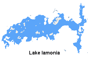
Lake Iamonia is a large, subtropical prairie lake in northern Leon County, Florida, United States, created during the Pleistocene epoch.

Cody Scarp

The Cody Scarp or Cody Escarpment is located in north and north central Florida United States. It is a relict scarp and ancient persistent topographical feature formed from an ancient early Pleistocene shorelines of ~1.8 million to 10,000 years BP during interglacial periods. The Cody Scarp has a slope of 5% to 12%.

Lake Chicago

Lake Chicago was a prehistoric proglacial lake that is the ancestor of what is now known as Lake Michigan, one of North America's five Great Lakes. Fed by retreating glaciers, it drained south through the Chicago Outlet River.

Glacial history of Minnesota

The glacial history of Minnesota is most defined since the onset of the last glacial period, which ended some 10,000 years ago. Within the last million years, most of the Midwestern United States and much of Canada were covered at one time or another with an ice sheet. This continental glacier had a profound effect on the surface features of the area over which it moved. Vast quantities of rock and soil were scraped from the glacial centers to its margins by slowly moving ice and redeposited as drift or till. Much of this drift was dumped into old preglacial river valleys, while some of it was heaped into belts of hills at the margin of the glacier. The chief result of glaciation has been the modification of the preglacial topography by the deposition of drift over the countryside. However, continental glaciers possess great power of erosion and may actually modify the preglacial land surface by scouring and abrading rather than by the deposition of the drift.

The Sangamonian Stage is the term used in North America to designate the last interglacial period. In its most common usage, it is used for the period of time between 75,000 and 125,000 BP. This period of time is equivalent to all of Marine Isotope Stage 5 and the combined Eemian period and early part of the Weichselian glaciation in Europe. Less commonly, the Sangamonian Stage is restricted to the period between 122,000 and 132,000 BP, which is equivalent to Marine Oxygen Isotope Substage 5e and the Eemian period of Europe. It preceded the Wisconsinan (Wisconsin) Stage and followed the Illinoian Stage in North America.

Ocala Platform

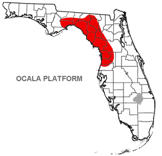
The Ocala Platform or Ocala Uplift is a geologic feature, a structural high, and a northwest-trending uplift paralleling the Peninsular Arch along the west coast.

Okeechobean Sea

The Okeechobean Sea was a Cenozoic eutropical subsea, which along with the Choctaw Sea, occupied the eastern Gulf of Mexico basin system bounding Florida.

Kissimmee/Okeechobee Lowland

The Kissimmee/Okeechobee Lowland is one of 47 distinct lake regions within the state of Florida, United States.

Floridas Hazelhurst terrace and shoreline

Florida's Hazelhurst terrace and shoreline is an ancient relict shoreline or delta present in the southeastern United States's Atlantic seaboard dating from the Late Miocene to Early Pliocene.

The Gulf Coastal Lowlands is a geomorphological province in Florida. The province extends along the coast of the Gulf of Mexico from the western end of the Florida Panhandle to near Ft. Myers in southern Florida. The average width of the province is 40 km. While much of the province is less than 15 m above mean sea level (msl), it rises to about 100 feet (30 m) above msl along its inland side. It is the largest geomorphological province in Florida. Due to its low elevation, the province was at sea level during warmer periods of the Pliocene and Pleistocene, and features such as ancient dunes and sand bars are found far inland. Marine terraces found in the Gulf Coastal Lowlands include the Silver Bluff [1 foot (0.30 m) to 10 feet (3.0 m) above mean sea level (msl)], Pamlico [8 feet (2.4 m) to 25 feet (7.6 m) above msl], Talbot [25 feet (7.6 m) to 42 feet (13 m) above msl], Penholoway [42 feet (13 m) to 72 feet (22 m) above msl] and Wicomico [70 feet (21 m) to 100 feet (30 m) above msl] terraces.

Lake Kankakee

Lake Kankakee formed 14,000 years before present (YBP) in the valley of the Kankakee River. It developed from the outwash of the Michigan Lobe, Saginaw Lobe, and the Huron-Erie Lobe of the Wisconsin glaciation. These three ice sheets formed a basin across Northwestern Indiana. It was a time when the glaciers were receding, but had stopped for a thousand years in these locations. The lake drained about 13,000 YBP, until reaching the level of the Momence Ledge. The outcropping of limestone created an artificial base level, holding water throughout the upper basin, creating the Grand Kankakee Marsh.

Lake Monongahela

Lake Monongahela was a proglacial lake in western Pennsylvania, West Virginia, and Ohio. It formed during the Pre-Illinoian ice epoch when the retreat of the ice sheet northwards blocked the drainage of these valleys to the north. The lake formed south of the ice front continued to rise until it was able to breach a low divide near New Martinsville, West Virginia. The overflow was the beginning of the process which created the modern Ohio River valley.

The geology of Estonia is the study of rocks, minerals, water, landforms and geologic history in Estonia. The crust is part of the East European Craton and formed beginning in the Paleoproterozoic nearly two billion years ago. Shallow marine environments predominated in Estonia, producing extensive natural resources from organic matter such as oil shale and phosphorite. The Mesozoic and much of the Cenozoic are not well-preserved in the rock record, although the glaciations during the Pleistocene buried deep valleys in sediment, rechanneled streams and left a landscape of extensive lakes and peat bogs.

References

  1. Cooke, C. W., Seven coastal terraces in the Southeastern states, Washington Academy of Science Journal, v. 21, number 21, p. 503-515
  2. Miller, James J., An environmental history of northeast Florida, University Press of Florida, 1st edition, 1998, ISBN   0-8130-1600-2
  3. Hendry, C. W., Jr., and Sproul, C., Geology and groundwater resources of Leon County, Florida: Florida Geological Survey Bulletin 48, 1066.
  4. Tappwater.org Lake Lafayette history Archived 2010-03-01 at the Wayback Machine
  5. Kurtén, Bjorn, Anderson, Elaine. Pleistocene mammals of North America, Columbia University Press, October 15, 1980, ISBN   0-231-03733-3
  6. GeoScience World, Rates and possible causes of neotectonic vertical crustal movements of the emerged southeastern United States Atlantic Coastal Plain, Thomas M. Cronin, U.S. Geological Survey, M.S. 970
  7. Volusuia County, Florida Natural History Archived 2010-06-13 at the Wayback Machine

USGS Terrace and shoreline map of Florida.