The Calico Early Man Site is an archaeological site in an ancient Pleistocene lake located near Barstow in San Bernardino County in the central Mojave Desert of Southern California. This site is on and in late middle-Pleistocene fanglomerates known variously as the Calico Hills, the Yermo Hills, or the Yermo formation. Holocene evidence includes petroglyphs and trail segments that are probably related to outcrops of local high-quality siliceous rock.
The Meadowcroft Rockshelter is an archaeological site which is located near Avella in Jefferson Township, Pennsylvania. The site is a rock shelter in a bluff overlooking Cross Creek, and contains evidence that the area may have been continually inhabited for more than 19,000 years. If accurately dated, it would be one of the earliest known sites with evidence of a human presence and continuous human occupation in the New World.
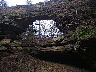
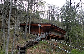
Natural Bridge State Park is a 530-acre (214 ha) state park of Wisconsin, United States, featuring Wisconsin's largest natural arch. Directly beneath the arch is the Raddatz Rockshelter, a rock shelter once used by Paleo-Indians and now listed on the National Register of Historic Places. The park is located southwest of Baraboo between the unincorporated communities of Leland and Denzer, in the town of Honey Creek.

Fort Rock Cave was the site of the earliest evidence of human habitation in the US state of Oregon before the excavation of Paisley Caves. Fort Rock Cave featured numerous well-preserved sagebrush sandals, ranging from 9,000 to 13,000 years old. The cave is located approximately 1.5 miles (2.4 km) west of Fort Rock near Fort Rock State Natural Area in Lake County. Fort Rock Cave was declared a National Historic Landmark in 1961, and added to the National Register of Historic Places in 1966.

The Kincaid Mounds Historic Site c. 1050–1400 CE, is a Mississippian culture archaeological site located at the southern tip of present-day U.S. state of Illinois, along the Ohio River. Kincaid Mounds has been notable for both its significant role in native North American prehistory and for the central role the site has played in the development of modern archaeological techniques. The site had at least 11 substructure platform mounds, and 8 other monuments.
Hester Site is a major prehistoric archaeological site in Monroe County, Mississippi. It is a multicomponent site whose major occupation took place during the Archaic period with artifacts dating from 9000 to 8000 BCE, and other occupations during the Woodland and Mississippian periods. The site is one of the largest Archaic sites in the southeastern United States, and its well-stratified nature was critical in providing for accurate relative dating of finds at other sites throughout the region. The site was declared a National Historic Landmark in 2001.

The Amalik Bay Archeological District is a geographic area with a significant number of archaeological sites in Alaska. It is located on the Pacific coast of Katmai National Park and Preserve, in the mainland portion of Kodiak Island Borough, Alaska.

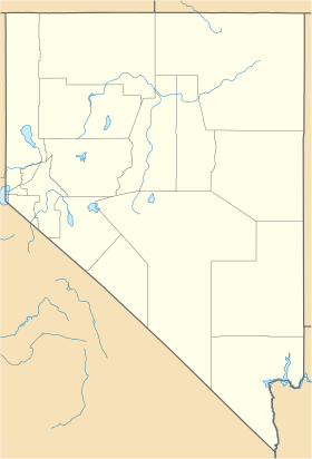
Gatecliff Rockshelter (26NY301) is a major archaeological site in the Great Basin area of the western United States that provides remarkable stratigraphy; it has been called the "deepest archaeological rock shelter in the Americas". Located in Mill Canyon of the Toquima Range in the Monitor Valley of central Nevada, Gatecliff Rockshelter has an elevation of 7,750 feet (2,360 m). David Hurst Thomas discovered Gatecliff Rockshelter in 1970 and began excavations in 1971. Full scale excavations occurred at Gatecliff Rockshelter for about seven field seasons in which nearly 33 feet (10 m) of sediments were exposed for a well-defined stratigraphic sequence. The well-preserved artifacts and undisturbed sediments at Gatecliff Rockshelter provides data and information have been applied to a range of research topics. Based on the analysis of the artifacts at Gatecliff Rockshelter, it can be determined that it was most likely a short-term field camp throughout prehistory. The latest evidence for human usage at Gatecliff occurs between ca. 5500 B.P. to 1250 B.P.
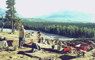
The Dry Creek Archeological Site is an archaeological site not far outside Denali National Park and Preserve. It is a multi-component site, whose stratified remains have yielded evidence of human occupation as far back as 11,000 years ago. The site is located on the northern flanks of the Alaska Range, near Healy, Alaska, in the Nenana River watershed. There are four major components to the site, layered in an outwash terrace overlooking Dry Creek, with layers of loess separating them.
The Palugvik Site, also known as Palugvik Archeological District, is an archaeological site on Hawkins Island in Prince William Sound, near Cordova, Alaska, within Chugach National Forest. The site, first excavated in 1930, was the first to provide a view of prehistoric human habitation in Prince William Sound, the ancestral home of the Chugach people, and is one of the two primary sites for identifying the sequence of occupation in the area. The site was declared a National Historic Landmark in 1962, and listed on the National Register of Historic Places in 1966.

The Mitchell Site, designated by the Smithsonian trinomial 39DV2, is an important archaeological site in Mitchell, Davison County, South Dakota. It was declared a National Historic Landmark in 1964. At that time it was the only reliably dated site of the Lower James River Phase. The site, sheltered under a dome, is managed by a nonprofit organization and is open to the public as Mitchell Prehistoric Indian Village. Visitors can watch archaeologists uncover artifacts in the Thomsen Center Archeodome. The Boehnen Memorial Museum features a reconstructed lodge and many of the artifacts found at the site.
Robert Fleming Heizer was an archaeologist who conducted extensive fieldwork and reporting in California, the Southwestern United States, and the Great Basin.

The LoDaisKa site is a prominent archaeological site in the U.S. state of Colorado, located within a rockshelter near Morrison. The rockshelter was first inhabited by people of the Archaic through the Middle Ceramic period, generally spanning 3000 BC to 1000 AD.

Robert Laurens Kelly is an American anthropologist who is a professor at the University of Wyoming. As a professor, he has taught introductory Archaeology as well as upper-level courses focused in Hunter-Gathers, North American Archaeology, Lithic Analysis, and Human Behavioral Ecology. Kelly's interest in archaeology began when he was a sophomore in high school in 1973. His first experience in fieldwork was an excavation of Gatecliff Rockshelter, a prehistoric site in central Nevada. Since then, Kelly has been involved with archaeology and has dedicated the majority of his work to the ethnology, ethnography, and archaeology of foraging peoples, which include research on lithic technology, initial colonization of the New World, evolutionary ecology of hunter-gatherers, and archaeological method and theory. He has been involved in research projects throughout the United States and in Chile, where he studied the remains of the Inca as well as coastal shell middens, and Madagascar, where in order to learn about farmer-forager society, Kelly has participated in ethnoarchaeological research. A majority of his work has been carried out in the Great Basin, but after moving to Wyoming in 1997 he has shifted his research to the rockshelters in the southwest Wyoming and the Bighorn Mountains.

Franktown Cave is located 25 miles (40 km) south of Denver, Colorado on the north edge of the Palmer Divide. It is the largest rock shelter documented on the Palmer Divide, which contains artifacts from many prehistoric cultures. Prehistoric hunter-gatherers occupied Franktown Cave intermittently for 8,000 years beginning about 6400 BC The site held remarkable lithic and ceramic artifacts, but it is better known for its perishable artifacts, including animal hides, wood, fiber and corn. Material goods were produced for their comfort, task-simplification and religious celebration. There is evidence of the site being a campsite or dwelling as recently as AD 1725.
The Cherry Creek Rockshelter is an archaeological site in central Colorado, located within modern-day Castlewood Canyon State Park near Franktown, Colorado. Current research indicates that it was used by Native American inhabitants beginning in the Archaic period. The site is situated on the Palmer Divide, which allowed for a unique prehistoric environment that contributed to an abundance of food and water sources, as well as lithic materials for tool-making. These factors, combined with the structure and situation of the shelter itself, made the site a particularly attractive environment for prehistoric peoples to settle in. Archaeological study of the site began in 1955, with the most current original research concluding in 2002.

Humboldt Cave is an archeological site in Churchill County, Nevada. Thirty-one caches were excavated from the cave, but there is only one radiocarbon date of 1953±175 14C BP from the cave, which suggests that Humboldt Cave may have only been a single cultural component. In other words, the caches from the cave may have only been deposited once and at the same time.

The Hidden Valley Rockshelter (44-BA-31) is a significant archaeological site located near the community of Warm Springs in Bath County, Virginia, United States. A large rockshelter located near the Jackson River, it has been occupied by humans for thousands of years, and it has been named a historic site.
The Rumford Archaeological Sites are a collection of prehistoric Native American sites in the vicinity of the Androscoggin River near Rumford, Maine. These six sites provide a window of observation into the movements and practices of Native Americans from c. 7,000 BCE to the Late Woodland period and contact with Europeans. These sites are the subject of three separate listings on the National Register of Historic Places in 1972: the Rumford Falls I-IV Sites, the Rumford V Site, and the Town of Rumford Site. The locations of these sensitive sites are not generally publicized.
Archeological Site No. 74-2 is a prehistoric site in Indian Island, Maine. Located on a terrace above the Penobscot River, the site dates to the Middle Archaic Period, a rarity in Maine, made even more unusual by the absence of later period artifacts. The site was listed on the National Register of Historic Places in 1984, for its potential to increase what is known about Native settlement patterns in the area.