National Register of Historic Places listings in Pershing County, Nevada

Last updated
Map all coordinates using: OpenStreetMap  
Download coordinates as: KML  ·  GPX

Contents:List of Registered Historic Places in Pershing County, Nevada , USA:

National Register of Historic Places federal list of historic sites in the United States

The National Register of Historic Places (NRHP) is the United States federal government's official list of districts, sites, buildings, structures, and objects deemed worthy of preservation for their historical significance. A property listed in the National Register, or located within a National Register Historic District, may qualify for tax incentives derived from the total value of expenses incurred preserving the property.

Pershing County, Nevada County in the United States

Pershing County is a county in the U.S. state of Nevada. As of the 2010 census, the population was 6,753. Its county seat is Lovelock. The county was named after army general John J. Pershing (1860–1948). It was formed from Humboldt County in 1919, and the last county to be established in Nevada. The Black Rock Desert, location for the annual Burning Man festival, is partially in the county.

Contents

The locations of National Register properties and districts (at least for all showing latitude and longitude coordinates below), may be seen in an online map by clicking on "Map of all coordinates". [1]

This National Park Service list is complete through NPS recent listings posted May 17, 2019. [2]
Contents: Counties in Nevada / See also: Nevada state-wide list

Contents:National Register of Historic Places listings in Carson City, Nevada, USA:

List of Registered Historic Places in Churchill County, Nevada, USA:

List of Registered Historic Places in Clark County, Nevada, USA:

Current listings

[3] Name on the RegisterImageDate listed [4] Location City or townDescription
1 Applegate-Lassen Trail December 18, 1978
(#78001722)
Trail extends from Rye Patch northwest to state line
41°11′45″N119°16′36″W / 41.195833°N 119.276667°W / 41.195833; -119.276667 (Applegate-Lassen Trail)
Black Rock Desert
2 Central Pacific Railroad Depot
Central Pacific Railroad Depot CENTRAL PACIFIC RAILROAD DEPOT, PERSHING COUNTY, NEVADA.jpg
Central Pacific Railroad Depot
April 15, 2004
(#04000300)
1005 W. Broadway Ave.
40°10′47″N118°28′22″W / 40.179722°N 118.472778°W / 40.179722; -118.472778 (Central Pacific Railroad Depot)
Lovelock
3 Dave Canyon, Se'aquada, Table Mountain March 23, 2005
(#05000207)
Address Restricted
Lovelock
4 Leonard Rock Shelter October 15, 1966
(#66000457)
Address Restricted
Lovelock
5 Marzen House
Marzen House MARZEN HOUSE, PERSHING COUNTY, NEVADA.jpg
Marzen House
August 27, 1981
(#81000384)
South of Lovelock
40°10′15″N118°28′53″W / 40.170833°N 118.481389°W / 40.170833; -118.481389 (Marzen House)
Lovelock
6 Pershing County Courthouse
Pershing County Courthouse Pershingcourt.JPG
Pershing County Courthouse
May 13, 1986
(#86001077)
400 Main St.
40°08′35″N118°30′09″W / 40.143056°N 118.5025°W / 40.143056; -118.5025 (Pershing County Courthouse)
Lovelock
7 Rye Patch Archeological Sites August 2, 1978
(#78001726)
Address Restricted
Lovelock
8 US Post Office-Lovelock Main
US Post Office-Lovelock Main 48US POST OFFICE - LOVELOCK MAIN, PERSHING COUNTY, NEVADA.jpg
US Post Office-Lovelock Main
February 28, 1990
(#90000134)
390 Main St.
40°10′51″N118°28′28″W / 40.180833°N 118.474444°W / 40.180833; -118.474444 (US Post Office-Lovelock Main)
Lovelock
9 Vocational-Agriculture Building
Vocational-Agriculture Building Vocational Agricultural Building - Pershing County School District Offices.jpg
Vocational-Agriculture Building
October 24, 1991
(#91001528)
1170 Elmhurst St.
40°14′46″N118°32′57″W / 40.246111°N 118.549167°W / 40.246111; -118.549167 (Vocational-Agriculture Building)
Lovelock

See also

National Register of Historic Places listings in Nevada Wikimedia list article

This is a list of properties and historic districts in Nevada that are listed on the National Register of Historic Places. There is at least one listing in each of Nevada's 16 counties and one independent city.

Related Research Articles

This is a list of properties and historic districts in Milton, Massachusetts, that are listed on the National Register of Historic Places.

National Register of Historic Places listings in Nevada County, California Wikimedia list article

This is a list of the National Register of Historic Places listings in Nevada County, California.

National Register of Historic Places listings in Perquimans County, North Carolina Wikimedia list article

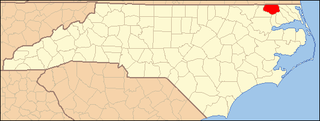
This list includes properties and districts listed on the National Register of Historic Places in Perquimans County, North Carolina. Click the "Map of all coordinates" link to the right to view a Google map of all properties and districts with latitude and longitude coordinates in the table below.

National Register of Historic Places listings in Surry County, North Carolina Wikimedia list article

This list includes properties and districts listed on the National Register of Historic Places in Surry County, North Carolina, United States. Click the "Map of all coordinates" link to the right to view a Google map of all properties and districts with latitude and longitude coordinates in the table below.

National Register of Historic Places listings in Davie County, North Carolina Wikimedia list article

This list includes properties and districts listed on the National Register of Historic Places in Davie County, North Carolina. Click the "Map of all coordinates" link to the right to view a Google map of all properties and districts with latitude and longitude coordinates in the table below.

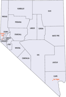
Contents:List of Registered Historic Places in Lander County, Nevada, USA:

National Register of Historic Places listings in Cherokee County, North Carolina Wikimedia list article

This list includes properties and districts listed on the National Register of Historic Places in Cherokee County, North Carolina. Click the "Map of all coordinates" link to the right to view an online map of all properties and districts with latitude and longitude coordinates in the table below.

Contents:List of Registered Historic Places in Humboldt County, Nevada, USA:

National Register of Historic Places listings in Gates County, North Carolina Wikimedia list article

This list includes properties and districts listed on the National Register of Historic Places in Gates County, North Carolina. Click the "Map of all coordinates" link to the right to view a Google map of all properties and districts with latitude and longitude coordinates in the table below.

National Register of Historic Places listings in McDowell County, North Carolina Wikimedia list article

This list includes properties and districts listed on the National Register of Historic Places in McDowell County, North Carolina. Click the "Map of all coordinates" link to the right to view a Google map of all properties and districts with latitude and longitude coordinates in the table below.

Contents:List of Registered Historic Places in Nye County, Nevada, USA:

List of Registered Historic Places in Elko County, Nevada, USA:

Contents:List of Registered Historic Places in Esmeralda County, Nevada, USA:

Contents:List of Registered Historic Places in Eureka County, Nevada, USA

Contents:List of Registered Historic Places in Lincoln County, Nevada, USA:

Contents:List of Registered Historic Places in Lyon County, Nevada, USA:

Contents:List of Registered Historic Places in Mineral County, Nevada, USA:

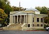
Contents:List of Registered Historic Places in Storey County, Nevada, USA:

References

  1. The latitude and longitude information provided in this table was derived originally from the National Register Information System, which has been found to be fairly accurate for about 99% of listings. For about 1% of NRIS original coordinates, experience has shown that one or both coordinates are typos or otherwise extremely far off; some corrections may have been made. A more subtle problem causes many locations to be off by up to 150 yards, depending on location in the country: most NRIS coordinates were derived from tracing out latitude and longitudes from USGS topographical quadrant maps created under the North American Datum of 1927 , which differs from the current, highly accurate WGS84 GPS system used by most on-line maps. Chicago is about right, but NRIS longitudes in Washington are higher by about 4.5 seconds, and are lower by about 2.0 seconds in Maine. Latitudes differ by about 1.0 second in Florida. Some locations in this table may have been corrected to current GPS standards.
  2. "National Register of Historic Places: Weekly List Actions". National Park Service, United States Department of the Interior. Retrieved on May 17, 2019.
  3. Numbers represent an ordering by significant words. Various colorings, defined here, differentiate National Historic Landmarks and historic districts from other NRHP buildings, structures, sites or objects.
  4. The eight-digit number below each date is the number assigned to each location in the National Register Information System database, which can be viewed by clicking the number.