
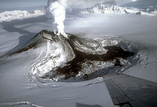
A volcano is a rupture in the crust of a planetary-mass object, such as Earth, that allows hot lava, volcanic ash, and gases to escape from a magma chamber below the surface.

Klyuchevskaya Sopka is a stratovolcano, the highest mountain of Siberia and the highest active volcano of Eurasia. Its steep, symmetrical cone towers about 100 kilometres (60 mi) from the Bering Sea. The volcano is part of the natural Volcanoes of Kamchatka UNESCO World Heritage Site.

These lists cover volcanoes by type and by location.

Atlasov Island, known in Russian as Ostrov Atlasova (Остров Атласова), or in Japanese as Araido (阿頼度島), is the northernmost island and volcano and also the highest volcano of the Kuril islands, part of the Sakhalin Oblast in Russia. The Russian name is sometimes rendered in English as Atlasova Island. Other names for the island include Uyakhuzhach, Oyakoba and Alaid, the name of the volcano on the island.

The Kamchatka Peninsula is a 1,250-kilometre-long (777 mi) peninsula in the Russian Far East, with an area of about 270,000 km2 (104,248 sq mi). The Pacific Ocean and the Sea of Okhotsk make up the peninsula's eastern and western coastlines, respectively. Immediately offshore along the Pacific coast of the peninsula runs the 10,500-metre-deep (34,449 ft) Kuril–Kamchatka Trench.

Mount Shishaldin is a moderately active volcano on Unimak Island in the Aleutian Islands chain of Alaska. It is the highest mountain peak of the Aleutian Islands. The most symmetrical cone-shaped glacier-clad large mountain on Earth, the volcano's topographic contour lines are nearly perfect circles above 6,500 feet (1,981 m). The lower north and south slopes are somewhat steeper than the lower eastern and western slopes. The volcano is the westernmost of three large stratovolcanoes along an east–west line in the eastern half of Unimak Island.
Mount Veniaminof is an active stratovolcano on the Alaska Peninsula. The mountain was named after Ioann Veniaminov (1797–1879), a Russian Orthodox missionary priest whose writings on the Aleut language and ethnology are still standard references. He is a saint of the Orthodox Church, known as Saint Innocent for the monastic name he used in later life.

Mount Vsevidof is a stratovolcano in the U.S. state of Alaska. Its summit is the highest point on Umnak Island, one of the eastern Aleutian Islands. Its symmetrical cone rises abruptly from its surroundings. The base of the volcano is around 10 km (6 mi) wide, steepening from about 15 degrees at 300 m (980 ft) altitude to around 30 degrees near the summit. Some glacial tongues have cut through narrow canyons up to 120 m (390 ft) deep, due to ice filling the crater and extending down the north and east flanks of the cone. Vsevidof's most recent eruption was caused by an earthquake on March 9, 1957. The mountain erupted on March 11, 1957, and the eruption ended the next day.
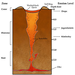
Volcanic pipes or volcanic conduits are subterranean geological structures formed by the violent, supersonic eruption of deep-origin volcanoes. They are considered to be a type of diatreme. Volcanic pipes are composed of a deep, narrow cone of solidified magma, and are usually largely composed of one of two characteristic rock types — kimberlite or lamproite. These rocks reflect the composition of the volcanoes' deep magma sources, where the Earth is rich in magnesium. Volcanic pipes are relatively rare. They are well known as the primary source of diamonds, and are mined for this purpose.

Koryaksky or Koryakskaya Sopka is an active volcano on the Kamchatka Peninsula in the Russian Far East. It lies within sight of Kamchatka Krai's administrative center, Petropavlovsk-Kamchatsky. Together with neighbouring Avachinsky, it has been designated a Decade Volcano, worthy of particular study in light of its history of explosive eruptions and proximity to populated areas.

A somma volcano is a volcanic caldera that has been partially filled by a new central cone. The name comes from Mount Somma, a stratovolcano in southern Italy with a summit caldera in which the upper cone of Mount Vesuvius has grown.
Kamchatka Krai is a federal subject of Russia, situated in the Russian Far East, and is administratively part of the Far Eastern Federal District. Its capital and largest city is Petropavlovsk-Kamchatsky, home to over half of its population of 322,079 (2010).

A tuya is a flat-topped, steep-sided volcano formed when lava erupts through a thick glacier or ice sheet. They are rare worldwide, being confined to regions which were covered by glaciers and had active volcanism during the same period.

A complex volcano, also called a compound volcano or a volcanic complex, is a mixed landform consisting of related volcanic centers and their associated lava flows and pyroclastic rock. They may form due to changes in eruptive habit or in the location of the principal vent area on a particular volcano. Stratovolcanoes can also form a large caldera that gets filled in by a lava dome, or else multiple small cinder cones, lava domes and craters may develop on the caldera's rim.

Ebeko is a highly active somma volcano located on the northern end of Paramushir Island, Kuril Islands, Russia. It is one of the most active volcanoes of the Kuril Islands. Eleven eruptions have been recorded between 1793 and 1991. Most of the eruptions are small (VEI=1) with the exception of the 1859 eruption (VEI=3). Most eruptions were phreatic and explosive.

Tyatya is a volcano located in the northeastern part of Kunashir Island, Kuril Islands, Russia. It is the highest peak on the island with an elevation of 1,819 metres (5,968 ft). Tyatya is one of the finest examples anywhere in the world of a somma volcano, a stratovolcano whose summit has collapsed to form a caldera which has then been mostly refilled by a new, younger volcanic cone which rises above the caldera rim.
Pogromni Volcano is a stratovolcano on Unimak Island in the Aleutian Islands. Near it are 5 cinder cones, and a mountain called Pogromni's Sister.

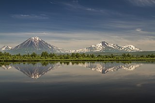
The volcanoes of Kamchatka are a large group of volcanoes situated on the Kamchatka Peninsula, in eastern Russia. The Kamchatka River and the surrounding central side valley are flanked by large volcanic belts containing around 160 volcanoes, 29 of them still active. The peninsula has a high density of volcanoes and associated volcanic phenomena, with 29 active volcanoes being included in the six UNESCO World Heritage List sites in the Volcanoes of Kamchatka group, most of them on the Kamchatka Peninsula.
