Related Research Articles
Haripur District is a district in the Hazara Division of Khyber Pakhtunkhwa, Pakistan.

Chakwal District is in Pothohar Plateau of Punjab, Pakistan. It is located in the north of the Punjab province, Chakwal district is bordered by Talagang to its south, Rawalpindi to its north east, Jhelum to its east, Talagang The district was created out of parts of Jhelum and Attock in 1985.

Gwadar District is a district in the Balochistan province of Pakistan. The name Gwadar originates from Gwat and Dar ، which means the door of air. Gwadar was notified as a separate district on 1 July 1977. The city of Gwadar serves as the district headquarters.

Khuzdar is a district in the Balochistan province of Pakistan. The city of Khuzdar serves as the district's headquarters.

Kalat was made a separate district on February 3, 1954. At that time Khuzdar and Mastung districts were sub-divisions of Kalat. Khuzdar became a separate district by notification of 1 March 1974, while Mastung was announced as a separate district on 18 February 1992. The district draws its name from the ancient city of Kalat. The old name of the district headquarters was Kahan. The current district consists of two sub-divisions, i.e. Kalat and Manguchar, four tehsils: Kalat Mangochar, Johan, and Gazgz, 81 Patwar circles and 614 mauza (villages).

Narowal District, located in upper punjab, is a district in the province of Punjab of Pakistan. Narowal city is the capital of the district. During the British rule, Narowal was the town of Raya Khas tehsil of Sialkot District. Narowal District formed in 1991, when the two tehsils of Narowal and Shakargarh were split off from Sialkot District.
Kalat Division or Qalat Division is an administrative division of Balochistan Province of Pakistan. Its capital city is Khuzdar founded on 14 October 1955. CNIC Code of Kalat Division is 51. According to 2023 Pakistani census population of Kalat Division is 2,719,964.
Qaim Bharwana is a town of Shorkot Tehsil, Jhang District in Punjab province of Pakistan.
Barana is a union council of Lalian tehsil in Chiniot District, Punjab province, Pakistan.
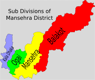
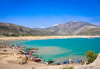
Oghi is a tehsil in Mansehra District, in the Khyber Pakhtunkhwa province of Pakistan. Its territory largely coincides with the Agror Valley, and its headquarters is the town of Oghi. Oghi Tehsil in Mansehra District, Khyber Pakhtunkhwa, Pakistan, was established in 1986. Prior to that, this area was part of Mansehra Tehsil. A decision was made by the government to reorganize tehsils and create new administrative units, and as a result, Oghi Tehsil was formed in this manner.

Lasbela District is a coastal district of Balochistan province of Pakistan.
Gadore is a town and union council of Bela Tehsil, Lasbela District, Balochistan, Pakistan. It is located at 26°10'50N 66°19'55E with an altitude of 52 metres.
Sakran is a town of Hub District in the Pakistani province of Balochistan. Most of the population are Sindhi Lasi, Balochi, Brahui, and Pashto. The main tribes are Bezanjo, Rakhsani, Marri, Rind, Gurginari, Mohammed Hasni, Sasoli, Qalandrani, Mengal, Meerwani, Qambrani, Shaikh, Jamot, Moondra, Wahora, and Kakar. 99% are Muslim while the remainder are Hindu and Christians.
Windar or Winder is capital city of Sonmiani Tehsil in Hub District, Balochistan province, Pakistan. It is located at 25°23'14N 66°39'55E with an altitude of 8 metres. Population is 29515 Majority are Sindhi, while minority are baloch and brahui. Majority are Muslim 98% while In Minority are Hinduism And Christianity.
Lakhra is a town and union council of Uthal Tehsil in Balochistan province, Pakistan. It is located at 25°51'54"N 66°27'6"E with an altitude of 12 metres.
Wayara or Wayaro is a town and union council of Uthal Tehsil in Balochistan province, Pakistan. It is located at 26°3'27N 66°30'12E with an altitude of 53 metres.

Khairpur Tamewali Tehsil is an administrative tehsil (subdivision" of Bahawalpur District in the Punjab province of Pakistan. The city of Khairpur Tamewali is the tehsil headquarters which is administratively subdivided into eight union councils.

Yazman is a tehsil located in Bahawalpur District, Punjab, Pakistan. The city of Yazman is the headquarters of the tehsil which is administratively subdivided into 18 Union Councils. With an area of 19,160 km square, it is the largest tehsil of the Punjab province.
Somiani is a coastal town in the southeastern Balochistan (Pakistan), located approximately 145 kilometres northwest of Karachi. Its coast marks the northernmost point of the Arabian Sea, and Sonmiani Beach is a popular destination for visitors from Karachi. The town also serves as the administrative centre (Tehsil) of Hub District. Sonmiani is notable for its space research and development, housing Somiani Spaceport. Additionally, the Pakistan Economic Coordination Commission has announced plans to build a liquid natural gas (LNG) terminal in the area.
KhuduKhel or Khudu Khel is a tehsil and Totalai is its central town. Totalai is located near district Swabi in the northwestern region of the country.
References
25°41′20″N66°29′26″E / 25.68889°N 66.49056°E
| | This Balochistan location article is a stub. You can help Wikipedia by expanding it. |