You can help expand this article with text translated from the corresponding article in Spanish. (April 2018)Click [show] for important translation instructions.
Machine translation, like DeepL or Google Translate, is a useful starting point for translations, but translators must revise errors as necessary and confirm that the translation is accurate, rather than simply copy-pasting machine-translated text into the English Wikipedia.
Do not translate text that appears unreliable or low-quality. If possible, verify the text with references provided in the foreign-language article.
You must provide copyright attribution in the edit summary accompanying your translation by providing an interlanguage link to the source of your translation. A model attribution edit summary is Content in this edit is translated from the existing Spanish Wikipedia article at [[:es:Municipio Libertador de Caracas]]; see its history for attribution.
You may also add the template {{Translated|es|Municipio Libertador de Caracas}} to the talk page.
Libertador is one of the smallest municipalities in Venezuela, with a total area of 438 square kilometres (169sqmi). It is the largest in terms of population, with approximately 2.1 million inhabitants.
It was first established in 1901 under the name of Libertador Department; with the Department of Vargas (now Vargas Municipality, it formed the Federal District of Venezuela.
In 1986, its name was changed to Libertador District. Following the creation of the Vargas State in 1998, it became the sole administrative division of the Federal District.
Under the 1999 constitution, the Federal District ceased to exist and the Capital District was created. Under the new terms of administrative divisions, Libertador became a municipality, consisting of 22 parishes.
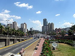
The Libertador Municipality is located in the mid-north of the country surrounded by the mountain El Ávila which is part of the Venezuelan central range. It borders by the north with the Vargas State, by the south and east with the Baruta Municipality of the Miranda State and by the west with the Aragua State. The Municipality includes the Los Chaguaramos neighborhood.
Climate
The climate is characteristically tropical with the temperature varying according to the altitude with an annual temperature of 24 to 28°C (75 to 82°F) being the warmest of the five municipalities that forms Caracas.
The vast majority of the population works for the public sector. It is also the most important commercial centre of the country since the Central Bank of Venezuela is located there. Tourism is the next largest economic activity in the municipality as the historical centre of the city is there. Informal commerce is also predominant in the area.
The Venezuelan constitution specifies that the municipal governments are divided by executive; governed by the mayor, and legislative branches; governed by the municipal council comprising thirteen members, both offices are elected through universal and secret suffrage.
The Libertador Municipality does not belong to any state therefore it doesn't have a governor but instead a Head of Government of the Capital District which is appointed by the President of the Republic.
Since August 2009 the municipality publishes a newspaper, Ciudad CCS.
The Libertador Municipality represents only 0.22% of the countrywide territory but is home to more than 2 million people and represents half of the total population of Caracas and a density of 4,816.36/km2. On the other hand, the entire area is urbanized.
As of 2006, Libertador was estimated to contain the world's second-largest mega-slum.[1]
This page is based on this Wikipedia article Text is available under the CC BY-SA 4.0 license; additional terms may apply. Images, videos and audio are available under their respective licenses.