Libertador Municipality, Caracas

Last updated
Libertador
Municipio Bolivariano Libertador
Municipality
Libertador Bolivarian Municipality
Caracas Cathedral 2.jpg
Caracas Cathedral
Venezuela - Distrito Capital - Libertador.svg
Capital District
Venezuela location map (+claimed).svg
Red pog.svg
Libertador
Location within Venezuela
Coordinates: 10°30′21″N66°54′52″W / 10.50583°N 66.91444°W / 10.50583; -66.91444
Country Flag of Venezuela.svg Venezuela
State Capital District
Founded25 July 1567
Government
  Type Mayor–council
   Mayor Erika Farías (PSUV)
Area
  Metro
433 km2 (167 sq mi)
Population
 (2007)
  Municipality2,085,488
  Density4,816.36/km2 (12,474.3/sq mi)
Time zone UTC−4 (VET)
Area code 212
ISO 3166 code VE-A
Website http://www.caracas.gob.ve
The area and population figures are for the municipality.

The Libertador Bolivarian Municipality (Spanish : Municipio Bolivariano Libertador) is the only administrative division of the Capital District of Venezuela and along with the municipalities of Baruta, Chacao, El Hatillo and Sucre forms the Metropolitan District of Caracas. It is landlocked by Vargas State and also borders Miranda State on the east and south. The municipality is one of a number in Venezuela named "Libertador Municipality", in honour of Venezuelan independence hero Simón Bolívar.

Contents

Libertador is one of the smallest municipalities in Venezuela, with a total area of 438 square kilometres (169 sq mi). It is the largest in terms of population, with approximately 2.1 million inhabitants.

In this municipality is home to the Miraflores presidential palace, the Federal Legislative Palace, the National Electoral Council, the main offices of PDVSA and CANTV, the Central Bank of Venezuela and the public ministry.

History

La Candelaria neighborhood in Caracas Vista de La Candelaria.jpg
La Candelaria neighborhood in Caracas

It was first established in 1901 under the name of Libertador Department; with the Department of Vargas (now Vargas Municipality, it formed the Federal District of Venezuela.

In 1986, its name was changed to Libertador District. Following the creation of the Vargas State in 1998, it became the sole administrative division of the Federal District.

Under the 1999 constitution, the Federal District ceased to exist and the Capital District was created. Under the new terms of administrative divisions, Libertador became a municipality, consisting of 22 parishes.

In 2000, the Metropolitan District of Caracas was formed from Libertador and four other municipalities: Baruta, Chacao, El Hatillo, and Sucre.

Geography

The Libertador Municipality is located in the mid-north of the country surrounded by the mountain El Ávila which is part of the Venezuelan central range. It borders by the north with the Vargas State, by the south and east with the Baruta Municipality of the Miranda State and by the west with the Aragua State. The Municipality includes the Los Chaguaramos neighborhood.

Climate

The climate is characteristically tropical with the temperature varying according to the altitude with an annual temperature of 24 to 28 °C (75 to 82 °F) being the warmest of the five municipalities that forms Caracas.

Economy

The vast majority of the population works for the public sector. It is also the most important commercial centre of the country since the Central Bank of Venezuela is located there. Tourism is the next largest economic activity in the municipality as the historical centre of the city is there. Informal commerce is also predominant in the area.

Bolivar Avenue Av Bolivar caracas2.jpg
Bolívar Avenue

Government

Libertador Municipality City Hall Cabildo Municipio Libertador, Caracas.jpg
Libertador Municipality City Hall
Parque Central Complex from the National Art Gallery Parque Central y la Galeria de Arte Nacional.jpg
Parque Central Complex from the National Art Gallery
Parroquias de caracas - libertador.svg

The Venezuelan constitution specifies that the municipal governments are divided by executive; governed by the mayor, and legislative branches; governed by the municipal council comprising thirteen members, both offices are elected through universal and secret suffrage.

The Libertador Municipality does not belong to any state therefore it doesn't have a governor but instead a Head of Government of the Capital District which is appointed by the President of the Republic.

Since August 2009 the municipality publishes a newspaper, Ciudad CCS .

Mayors

Parishes

The Libertador Municipality comprised 22 parishes out of the 32 that contains Caracas

ParishAreaPopulation (2007)
(1) Santa Rosalía 6,68 km²118.327
(2) El Valle 12,64 km²152.763
(3) Coche  ? km²57.907
(4) Caricuao 23,83 km²166.918
(5) Macarao 10,25 km²50.032
(6) Antímano 20,90 km²150.971
(7) La Vega 12,64 km²142.765
(8) El Paraíso 10,79 km²114.820
(9) El Junquito 52,52 km²45.398
(10) Sucre 59,30 km²396.919
(11) San Juan 3,25 km²101.777
(12) Santa Teresa 0,72 km²20.641
(13) 23 de enero 2,31 km²84.650 (2009)
(14) La Pastora 4,47 km²41.989
(15) Altagracia  ? km²89.670
(16) San José 2,59 km²39.196
(17) San Bernardino 12,27 km²26.296
(18) Catedral 0,76 km²5.479
(19) Candelaria 1,23 km²62.360
(20) San Agustín 1,59 km²46.757
(21) El Recreo 18,10 km²107.051
(22) San Pedro  ? km²62.641

Demographics

The Libertador Municipality represents only 0.22% of the countrywide territory but is home to more than 2 million people and represents half of the total population of Caracas and a density of 4,816.36/km2. On the other hand, the entire area is urbanized.

As of 2006, Libertador was estimated to contain the world's second-largest mega-slum. [1]

See also

Related Research Articles

<span class="mw-page-title-main">Caracas</span> Capital and largest city of Venezuela

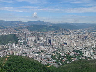
Caracas, officially Santiago de León de Caracas (CCS), is the capital and largest city of Venezuela, and the center of the Metropolitan Region of Caracas. Caracas is located along the Guaire River in the northern part of the country, within the Caracas Valley of the Venezuelan coastal mountain range. The valley is close to the Caribbean Sea, separated from the coast by a steep 2,200-meter-high (7,200 ft) mountain range, Cerro El Ávila; to the south there are more hills and mountains. The Metropolitan Region of Caracas has an estimated population of almost 5 million inhabitants.

<span class="mw-page-title-main">Miranda (state)</span> State of Venezuela

Miranda State is one of the 23 states of Venezuela and the second most populous after Zulia State. As of the 2011 census, it had a population of 2,675,165 residents. It also has the greatest Human Development Index in Venezuela, according to the Venezuelan National Institute of Statistics. The most recent population estimate was 3,194,390 in mid-2016.

<span class="mw-page-title-main">Vargas (state)</span> State of Venezuela

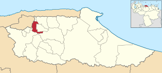
La Guaira State, known until 2019 as Vargas State is one of the 23 states of Venezuela. Formerly named after Venezuela's first civilian president, José María Vargas, Vargas comprises a coastal region in the north of Venezuela, bordering Aragua to the west, Miranda to the east, the Caribbean Sea to the north and the Capital District to the south. It is home to both the country's largest seaport and airport. The state capital and largest city is La Guaira followed by Catia La Mar and Maiquetía. The Litoral Varguense conurbation is the principal urban agglomeration in the state, which is part of the Greater Caracas Area.

<span class="mw-page-title-main">Capital District (Venezuela)</span> Federal district of Venezuela

The Capital District is a federal district of Venezuela. It has an area of 433 km2 (167 sq mi) and there is only one administrative division (municipio), Libertador, which contains about half of Caracas, the Venezuelan capital city, which is also the seat of the three branches of the federal government of Venezuela. The population in 2004 was 2,073,768. The District borders on the states of Vargas and Miranda.

<span class="mw-page-title-main">Chacao Municipality</span> Municipality in Miranda, Venezuela

Chacao is one of the five political and administrative subdivisions of the city of Caracas, Venezuela. The other four are Baruta, El Hatillo, Libertador and Sucre. This legal entity is known as the Caracas Metropolitan District. Chacao is also one of the 21 municipalities that make up the State of Miranda, Venezuela.

<span class="mw-page-title-main">Altamira, Caracas</span> Neighbourhood in Chacao Municipality, Miranda, Venezuela

Altamira is a neighborhood located in the Chacao municipality of Caracas, Venezuela. It has its own Metro Station, many hotels and restaurants, and it is an important business and residential center of the city. It is also an important tourist destination and cultural center in Caracas. The Francisco de Miranda avenue and the Distibuidor Altamira are both located in Altamira. This neighborhood borders El Ávila National Park to the north, La Castellana neighborhood to the west, Los Palos Grandes to the east, and Bello Campo neighborhood to the south. It has an estimated area of 161 hectares or approximately 1.61 square kilometers.

<span class="mw-page-title-main">Municipalities of Venezuela</span> Subdivisions of the States of Venezuela

Municipalities of Venezuela are subdivisions of the States of Venezuela. There are 335 municipalities dividing the 23 states and the Capital District.

<span class="mw-page-title-main">Baruta Municipality</span> Municipality in Miranda, Venezuela

Baruta is a municipality within the Metropolitan District of Caracas in Venezuela.

<span class="mw-page-title-main">El Hatillo Municipality</span> Municipality in Miranda, Venezuela

El Hatillo Municipality is an administrative division of the State of Miranda, Venezuela; along with Baruta, Chacao, Libertador and Sucre, it is one of the five municipalities of Caracas, the capital of Venezuela. It is located in the southeastern area of Caracas, and in the northwestern part of the State of Miranda.
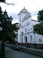
<span class="mw-page-title-main">Petare</span> Place in Miranda, Venezuela

Dulce Nombre de Jesus de Petare is a neighborhood in Miranda, Venezuela, and is part of the Metropolitan District of Caracas. It is located in the Sucre Municipality, one of the five divisions of Caracas. The city was founded in 1621 under the name of San Jose de Guanarito. It grew to become a part of the Greater Caracas area as the latter expanded in area and population. Petare had a population of 372,106 inhabitants and about 448,861 according to 2020 estimates. Petare is the biggest slum in Venezuela, and in South America.

<span class="mw-page-title-main">Francisco Fajardo Highway</span> Highway in Caracas, Venezuela

The Francisco Fajardo Highway is the most important freeway of Caracas, connecting the west and east sides of the city. The national freeways and many of the avenues of Caracas are not designated with a system of codification or numbering; instead they are designated with the names of historical personages. This highway is named for the conquistador Francisco Fajardo. Also in Caracas, the connections between freeways are also given peculiar names - the octopus, the spider and the centipede are examples.

<span class="mw-page-title-main">Venezuelans of European descent</span> Ethnic group

European Venezuelans or White Venezuelans are Venezuelan citizens who self-identify in the national census as white, tracing their heritage to European ethnic groups. According to the official census report, although "white" literally involves external issues such as light skin, shape and color of hair and eyes, among others, the term "white" has been used in different ways in different historical periods and places, and so its precise definition is somewhat confusing.

The following is a timeline of the history of the city of Caracas, Venezuela.

<span class="mw-page-title-main">Tourism in Venezuela</span>

Tourism in Venezuela has been developed considerably for decades, particularly because of its geographical position, the variety of landscapes, the richness of plants and wildlife, the artistic expressions and the privileged tropical climate of the country, which affords each region throughout the year. Since 2013, the country is having a very severe economic and political crisis affecting tourism all over the country.

<span class="mw-page-title-main">East Caracas</span> Municipalities of East Caracas in Miranda, Venezuela

East Caracas generally refers to the eastern portions of Caracas, and may refer specifically to the municipalities from the Metropolitan District of Caracas located in Miranda State: Chacao, Baruta, Sucre, and El Hatillo. It concentrates the 34.8% population of the Metropolitan District of Caracas, and the 21.7% population of the Greater Caracas Area. Caracas Country Club, the richest neighborhood of the city, is located between El Recreo and Chacao districts.

<span class="mw-page-title-main">Caterina Valentino</span>

Caterina Valentino is a Venezuelan-Italian journalist, television presenter, announcer, writer, actress, model and businesswoman. She is one of the most recognized and important figures in Venezuela and has won many awards for her professional work.

<span class="mw-page-title-main">Neighborhood Force</span> Political party in Venezuela

The Neighborhood Force is a centrist and localist Venezuelan political party, founded by a group of mayors and political leaders of the country on June 26, 2021. The party governs throughout eastern Caracas — in the municipalities Baruta, El Hatillo, Los Salias and Chacao— less in the Sucre Municipality. The party also governs the municipalities Diego Bautista Urbaneja and Maneiro, in eastern Venezuela.

<span class="mw-page-title-main">Gloria Lizárraga de Capriles</span> Venezuelan politician (1944–2021)

Gloria Lizárraga de Capriles was a Venezuelan politician who was the first mayor of the Baruta municipality elected by direct vote, as well as the first woman elected to the position. She has been described as one of the pioneering women in Venezuelan politics.

References

  1. Mike Davis, Planet of Slums, La Découverte, Paris, 2006 ( ISBN   978-2-7071-4915-2), p. 31.