The climate and ecology of land immediately surrounding the Mediterranean Sea is influenced by several factors. Overall, the land has a Mediterranean climate, with mild, rainy winters and hot, dry summers. The climate induces characteristic Mediterranean forests, woodlands, and scrub vegetation. Plant life immediately near the Mediterranean is in the Mediterranean Floristic region, while mountainous areas further from the sea supports the Sub-Mediterranean Floristic province.
An important factor in the local climate and ecology of the lands in the Mediterranean basin is the elevation: an increase of elevation by 1,000 metres (3,300ft) causes the average air temperature to drop by 5 C/ 9 F and decreases the amount of water that can be held by the atmosphere by 30%. This decrease in temperature and increase in rainfall result in altitudinal zonation, where the land can be divided into life zones of similar climate and ecology, depending on elevation.
Mediterranean vegetation shows a variety of ecological adaptations to hot and dry summer conditions. As Mediterranean vegetation differ both in species and composition from temperate vegetation, ecologists use special terminology for the Mediterranean altitudinal zonation:
Even within the Mediterranean Basin, differences in aridity alter the life zones as a function of elevation. For example, the wetter Maritime and Dinaric Alps have a North-Mediterranean zonation pattern, while the southern Apennine Mountains and the Spanish Sierra Nevada have a moderate Eu-Mediterranean zonation pattern. Finally, the drier Atlas Mountains of Africa have a Xero-Mediterranean pattern.[2]
A biome is a biogeographical unit consisting of a biological community that has formed in response to the physical environment in which they are found and a shared regional climate. Biomes may span more than one continent. Biome is a broader term than habitat and can comprise a variety of habitats.
The Democratic Republic of the Congo (DRC) is the largest country of sub-Saharan Africa, occupying some 2,344,858 square kilometres (905,355 sq mi). Most of the country lies within the vast hollow of the Congo River basin. The vast, low-lying central area is a plateau-shaped basin sloping toward the west, covered by tropical rainforest and criss-crossed by rivers. The forest center is surrounded by mountainous terraces in the west, plateaus merging into savannas in the south and southwest. Dense grasslands extend beyond the Congo River in the north. High mountains of the Ruwenzori Range are found on the eastern borders with Rwanda and Uganda.
Eritrea is located in the Horn of Africa and is bordered on the northeast and east by the Red Sea, on the west and northwest by Sudan, on the south by Ethiopia, and on the southeast by Djibouti. The country has a high central plateau that varies from 1,800 to 3,000 meters (5,906–9,843 ft) above sea level. A coastal plain, western lowlands, and some 350 islands comprise the remainder of Eritrea's land mass.
Morocco is the northwesternmost country which spans from the Mediterranean Sea and Atlantic Ocean on the north and the west respectively, into large mountainous areas in the interior, to the Sahara desert in the far south. Morocco is a Northern African country, located in the extreme northwest of Africa on the edge of continental Europe. The Strait of Gibraltar separates Spain from Morocco with a 13 kilometres (8.1 mi) span of water. Morocco borders the North Atlantic Ocean to the west, and the western Mediterranean Sea to the north, and has borders with Algeria and disputed Western Sahara.
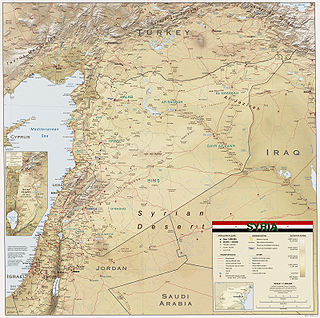
Syria is located in Western Asia, north of the Arabian Peninsula, at the eastern end of the Mediterranean Sea. It is bordered by Turkey to the north, Lebanon and Israel to the west and southwest, Iraq to the east, and Jordan to the south. It consists of mountain ranges in the west and a steep area inland. In the east is the Syrian Desert and in the south is the Jabal al-Druze Range. The former is bisected by the Euphrates valley. A dam built in 1973 on the Euphrates created a reservoir named Lake Assad, the largest lake in Syria. The highest point in Syria is Mount Hermon on the Lebanese border at 2,814 metres or 9,232 feet. Between the humid Mediterranean coast and the arid desert regions lies a semiarid steep zone extending across three-quarters of the country, which receives hot, dry winds blowing across the desert. Syria is extensively depleted, with 28 percent of the land arable, 4 percent dedicated to permanent crops, 46 percent utilized as meadows and pastures, and only 3 percent forest and woodland.
A mountain is an elevated portion of the Earth's crust, generally with steep sides that show significant exposed bedrock. Although definitions vary, a mountain may differ from a plateau in having a limited summit area, and is usually higher than a hill, typically rising at least 300 metres (980 ft) above the surrounding land. A few mountains are isolated summits, but most occur in mountain ranges.
In geography, the temperate climates of Earth occur in the middle latitudes, which span between the tropics and the polar regions of Earth. These zones generally have wider temperature ranges throughout the year and more distinct seasonal changes compared to tropical climates, where such variations are often small and usually only have precipitation changes.
A Mediterranean climate, also called a dry summer climate, described by Köppen as Cs, is a temperate climate type that occurs in the lower mid-latitudes. Such climates typically have dry summers and wet winters, with summer conditions ranging from warm to hot and winter conditions typically being mild. These weather conditions are typically experienced in the majority of Mediterranean-climate regions and countries, but remain highly dependent on proximity to the ocean, altitude and geographical location.
The Great Basin Desert is part of the Great Basin between the Sierra Nevada and the Wasatch Range. The desert is a geographical region that largely overlaps the Great Basin shrub steppe defined by the World Wildlife Fund, and the Central Basin and Range ecoregion defined by the U.S. Environmental Protection Agency and United States Geological Survey. It is a temperate desert with hot, dry summers and snowy winters. The desert spans large portions of Nevada and Utah, and extends into eastern California. The desert is one of the four biologically defined deserts in North America, in addition to the Mojave, Sonoran, and Chihuahuan Deserts.
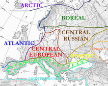
In biogeography, the Mediterranean Basin, also known as the Mediterranean Region or sometimes Mediterranea, is the region of lands around the Mediterranean Sea that have mostly a Mediterranean climate, with mild to cool, rainy winters and warm to hot, dry summers, which supports characteristic Mediterranean forests, woodlands, and scrub vegetation.
Climate of Peru describes the diverse climates of this large South American country with an area of 1,285,216 km2 (496,225 sq mi). Peru is located entirely in the tropics but features desert and mountain climates as well as tropical rainforests. Elevations above sea level in the country range from −37 to 6,778 m and precipitation ranges from less than 20 mm (0.79 in) annually to more than 8,000 mm (310 in). There are three main climatic regions: the Pacific Ocean coast is one of the driest deserts in the world but with some unique features; the high Andes mountains have a variety of microclimates depending on elevation and exposure and with temperatures and precipitation from temperate to polar and wet to dry; and the Amazon basin has tropical climates, mostly with abundant precipitation, along with sub-tropical climates in elevations above 1,550 m (5,090 ft).
The Holdridge life zones system is a global bioclimatic scheme for the classification of land areas. It was first published by Leslie Holdridge in 1947, and updated in 1967. It is a relatively simple system based on few empirical data, giving objective criteria. A basic assumption of the system is that both soil and the climax vegetation can be mapped once the climate is known.
The Climate of Colombia is characterized for being tropical and isothermal as a result of its geographical location near the Equator presenting variations within five natural regions and depending on the altitude, temperature, humidity, winds and rainfall. Each region maintains an average temperature throughout the year only presenting variables determined by precipitation during a rainy season caused by the Intertropical Convergence Zone.
Altitudinal zonation in mountainous regions describes the natural layering of ecosystems that occurs at distinct elevations due to varying environmental conditions. Temperature, humidity, soil composition, and solar radiation are important factors in determining altitudinal zones, which consequently support different vegetation and animal species. Altitudinal zonation was first hypothesized by geographer Alexander von Humboldt who noticed that temperature drops with increasing elevation. Zonation also occurs in intertidal and marine environments, as well as on shorelines and in wetlands. Scientist C. Hart Merriam observed that changes in vegetation and animals in altitudinal zones map onto changes expected with increased latitude in his concept of life zones. Today, altitudinal zonation represents a core concept in mountain research.
Turkey's climate is varied and generally temperate, with the regions bordering the Mediterranean and Black Sea heavily affected by the coasts, and the interior being drier and more continental. Western and southern coastal areas feature a Mediterranean climate, with hot, dry summers and mild, rainy winters. Temperatures get cooler and summer rain increases as one goes north. The areas around the Sea of Marmara are classified variously due to their transitional nature; while areas further east, south of the Black Sea, are classified as oceanic or humid subtropical. Inland areas are continental, with sub-humid or semi-arid rainfall regimes.
Montane ecosystems are found on the slopes of mountains. The alpine climate in these regions strongly affects the ecosystem because temperatures fall as elevation increases, causing the ecosystem to stratify. This stratification is a crucial factor in shaping plant community, biodiversity, metabolic processes and ecosystem dynamics for montane ecosystems. Dense montane forests are common at moderate elevations, due to moderate temperatures and high rainfall. At higher elevations, the climate is harsher, with lower temperatures and higher winds, preventing the growth of trees and causing the plant community to transition to montane grasslands, shrublands or alpine tundra. Due to the unique climate conditions of montane ecosystems, they contain increased numbers of endemic species. Montane ecosystems also exhibit variation in ecosystem services, which include carbon storage and water supply.
Elevational diversity gradient (EDG) is an ecological pattern where biodiversity changes with elevation. The EDG states that species richness tends to increase as elevation increases, up to a certain point, creating a "diversity bulge" at middle elevations. There have been multiple hypotheses proposed for explaining the EDG, none of which accurately describe the phenomenon in full.
Vegetation classification is the process of classifying and mapping the vegetation over an area of the earth's surface. Vegetation classification is often performed by state based agencies as part of land use, resource and environmental management. Many different methods of vegetation classification have been used. In general, there has been a shift from structural classification used by forestry for the mapping of timber resources, to floristic community mapping for biodiversity management. Whereas older forestry-based schemes considered factors such as height, species and density of the woody canopy, floristic community mapping shifts the emphasis onto ecological factors such as climate, soil type and floristic associations. Classification mapping is usually now done using geographic information systems (GIS) software.
The Mediterranean Biogeographic Region is the biogeographic region around and including the Mediterranean Sea. The term is defined by the European Environment Agency as applying to the land areas of Europe that border on the Mediterranean Sea, and the corresponding territorial waters. The region is rich in biodiversity and has many endemic species. The term may also be used in the broader sense of all the lands of the Mediterranean Basin, or in the narrow sense of just the Mediterranean Sea.
This page is based on this Wikipedia article Text is available under the CC BY-SA 4.0 license; additional terms may apply. Images, videos and audio are available under their respective licenses.