
Bolinas is an unincorporated coastal community and census-designated place in Marin County, California, United States. As of the 2020 census it had a population of 1,483. It is located on the California coast, approximately 13 miles (21 km) northwest of San Francisco, and 27 miles (43 km) by road.

Stinson Beach is an unincorporated community and census-designated place (CDP) in Marin County, California, on the west coast of the United States. Stinson Beach is located 2.5 miles (4 km) east-southeast of Bolinas, at an elevation of 26 feet (8 m). The population of the Stinson Beach CDP was 541 at the 2020 census.

Bolinas Bay is a small bay, approximately 5 miles (8 km) long, on the Pacific coast of California in the United States. It is in Marin County, north of the Golden Gate, approximately 15 miles (25 km) northwest of San Francisco. The town of Bolinas is at its shore.

Drakes Estero is an expansive estuary in the Point Reyes National Seashore of Marin County on the Pacific coast of northern California in the United States, approximately 25 miles (40 km) northwest of San Francisco.

Point Reyes is a prominent cape and popular Northern California tourist destination on the Pacific coast. Located in Marin County, it is approximately 30 miles (50 km) west-northwest of San Francisco. The term is often applied to the Point Reyes Peninsula, the region bounded by Tomales Bay on the northeast and Bolinas Lagoon on the southeast. The headland is protected as part of Point Reyes National Seashore.

Bodega Harbor is a small, shallow, natural harbor on the Pacific coast of northern California in the United States, approximately 40 mi (64 km) northwest of San Francisco. The harbor is approximately 2 sq mi (5.2 km2) in area.

Mount Tamalpais, known locally as Mount Tam, is a peak in Marin County, California, United States, often considered symbolic of Marin County. Much of Mount Tamalpais is protected within public lands such as Mount Tamalpais State Park, the Marin Municipal Water District watershed, and National Park Service land, such as Muir Woods.

Alameda Terminal was a railroad station and ferry wharf at the foot and west of present-day Pacific Avenue and Main Street in Alameda, California, on the eastern shore of San Francisco Bay with ferry service to San Francisco. It was built in 1864 and operated by the San Francisco and Alameda Railroad. In 1869, it served as the original west coast terminus of the U.S. First transcontinental railroad, until the opening of Oakland Pier two months later. The western terminus was inaugurated September 6, 1869, when the first Western Pacific through train from Sacramento reached the shores of San Francisco Bay at Alameda Terminal, — thus completing the first transcontinental railroad "from the Missouri river to the Pacific ocean" in accordance with the Pacific Railroad Acts.

Fort Mason, in San Francisco, California originated as a coastal defense site during the American Civil War. The nucleus of the property was owned by John C. Frémont and disputes over compensation by the United States continued into 1968. In 1882 the defenses were named for Richard Barnes Mason, a military governor before statehood. Fort Mason became the headquarters for an Army command that included California and the Hawaiian Islands from 1904 to 1907. In 1912 the Army began building a port facility with piers and warehouses to be a home base for ships of the Army Transport Service serving Alaska, Hawaii, the Philippines and other Pacific Army posts and focus of Army supply for the Pacific.

The Golden Gate National Recreation Area (GGNRA) is a U.S. National Recreation Area protecting 82,116 acres (33,231 ha) of ecologically and historically significant landscapes surrounding the San Francisco Bay Area. Much of the park is land formerly used by the United States Army. GGNRA is managed by the National Park Service and is the second-most visited unit of the National Park system in the United States, with more than 15.6 million visitors in 2022. It is also one of the largest urban parks in the world, with a size two-and-a-half times that of the consolidated city and county of San Francisco.

People in the San Francisco Bay Area rely on a complex multimodal transportation infrastructure consisting of roads, bridges, highways, rail, tunnels, airports, seaports, and bike and pedestrian paths. The development, maintenance, and operation of these different modes of transportation are overseen by various agencies, including the California Department of Transportation (Caltrans), the Association of Bay Area Governments, San Francisco Municipal Transportation Agency, and the Metropolitan Transportation Commission. These and other organizations collectively manage several interstate highways and state routes, eight passenger rail networks, eight trans-bay bridges, transbay ferry service, local and transbay bus service, three international airports, and an extensive network of roads, tunnels, and bike paths.

The Port of San Francisco is a semi-independent organization that oversees the port facilities at San Francisco, California, United States. It is run by a five-member commission, appointed by the Mayor and approved by the Board of Supervisors. The Port is responsible for managing the larger waterfront area that extends from the anchorage of the Golden Gate Bridge, along the Marina district, all the way around the north and east shores of the city of San Francisco including Fisherman's Wharf and the Embarcadero, and southward to the city line just beyond Candlestick Point. In 1968, the State of California, via the California State Lands Commission for the State-operated San Francisco Port Authority, transferred its responsibilities for the Harbor of San Francisco waterfront to the City and County of San Francisco / San Francisco Harbor Commission through the Burton Act AB2649. All eligible State port authority employees had the option to become employees of the City and County of San Francisco to maintain consistent operation of the Port of San Francisco.
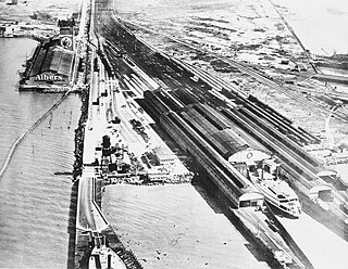
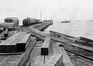
The Oakland Long Wharf was an 11,000-foot railroad wharf and ferry pier along the east shore of San Francisco Bay located at the foot of Seventh Street in West Oakland. The Oakland Long Wharf was built, beginning 1868, by the Central Pacific Railroad on what was previously Oakland Point. Beginning November 8, 1869, it served as the west coast terminus of the First transcontinental railroad. In the 1880s, Southern Pacific Railroad took over the CPRR, extending it and creating a new ferry terminal building with the official station name Oakland Pier. The entire structure became commonly and popularly called the Oakland Mole. Portions of the Wharf lasted until the 1960s. The site is now part of the facilities of the Port of Oakland, while passenger train service operates at the nearby Jack London Square/Dellums Station and another nearby station in Emeryville.

Aquatic Park Historic District is a National Historic Landmark and building complex on the San Francisco Bay waterfront within San Francisco Maritime National Historical Park.

The Marin Hills are a series of steep high ridges and peaks in southern Marin County. They are a part of the long Pacific Coast Ranges mountain system. The centerpoint of these hills is the 2,571 foot Mount Tamalpais near Mill Valley. The hills are bordered to the north by the Santa Rosa Plain and Laguna de Santa Rosa; to the east by San Pablo Bay, the northern arm of San Francisco Bay; to the south by Golden Gate Strait; and to the west by the San Andreas Fault, running through Tomales Bay, Olema Valley, Bolinas Lagoon, and Stinson Beach. Parts of the hills are protected for their scenic beauty by Mount Tamalpais State Park and the Golden Gate National Recreation Area. The many ridges and peaks of these hills form a dramatic backdrop to the Golden Gate Bridge, the San Francisco skyline, and several towns around Richardson Bay when viewed from the south.
Audubon Canyon Ranch (ACR) is a 501(c)(3) not-for-profit environmental conservation and education organization headquartered in Stinson Beach, Marin County, California, on the eastern shore of Bolinas Lagoon. The lands upon which ACR operates are within the ancestral territories of the Coast Miwok, Southern Pomo and Wappo peoples. ACR recognizes that Indigenous communities are very much alive today and striving to protect and maintain relationships with cultural and natural resources on ACR lands; they acknowledge that Indigenous lands are occupied by them and others.

Bolinas Ridge is a north-south ridge in southwestern Marin County, California. Much of the western side of the ridge is protected parkland in the Golden Gate National Recreation Area, and the eastern side is watershed lands of the Marin Municipal Water District.

The Long Wharf in Santa Monica, also known as Port Los Angeles or the Mile Long Pier, was an extensive pier wharf constructed by the Southern Pacific Railroad Company in Santa Monica Bay from 1892–94. When it opened in 1894, it was the longest wharf in the world, measuring approximately 4,700 feet (1,400 m). It served as a cargo and passenger port until 1913, and in 1919 removal of the wharf started. The wharf, the 1,000 foot (300 m) tip of the pier, was removed by 1920. The remaining 3,600 feet (1,100 m) of pier was used as a run down fishing pier until 1933, when the remainder of the pier was removed. One of the major imports to the wharf was lumber from Northern ports, to help in the construction boom in Southern California. Southern Pacific Railroad and the street cars of the Los Angeles Pacific Railroad served the wharf. Los Angeles Pacific Railroad ran passenger trams to the wharf and from midnight to sunrise ran cargo cars.
The place of McFadden Wharf was designated a California Historic Landmark (No.794) on July 3, 1964.


